![](/images/other/stat-length.png)
![Randonnée V.T.T. Marsanne - LES BALCONS DE MARSANNE - Marsanne (26 Drome) - Photo](https://media.geolcdn.com/t/1900/400/ext.pjpeg?maxdim=2&url=https%3A%2F%2Fstatic1.geolcdn.com%2Fsiteimages%2Fupload%2Ffiles%2F1524743154velo.jpg)
LES BALCONS DE MARSANNE - Marsanne (26 Drome)
charlytan
Utilisateur
![Longueur](/images/other/stat-length.png)
Longueur
28 km
![Altitude max](https://static1.geolcdn.com/siteimages/upload/files/1508320355ic_sort_altitude_max_24dp.png)
Altitude max
379 m
![Dénivelé positif](https://static1.geolcdn.com/siteimages/upload/files/1508320355ic_sort_den_pos_24dp.png)
Dénivelé positif
404 m
![Km-Effort](/images/other/stat-length.png)
Km-Effort
33 km
![Altitude min](https://static1.geolcdn.com/siteimages/upload/files/1508320355ic_sort_altitude_min_24dp.png)
Altitude min
151 m
![Dénivelé négatif](https://static1.geolcdn.com/siteimages/upload/files/1508320355ic_sort_den_neg_24dp.png)
Dénivelé négatif
406 m
![Boucle](https://static1.geolcdn.com/siteimages/upload/files/16400158638029165_repeat_loop_refresh_sync_direction_icon.png)
Boucle
Oui
Date de création :
2021-07-08 14:05:04.99
Dernière modification :
2021-07-08 14:29:39.48
![V.T.T.](https://static1.geolcdn.com/sitytour/trail-icons/202.png)
--
Difficulté : Inconnu
![Scannez ce code QR pour ouvrir la randonnée dans l'application SityTrail](https://capi.geolives.com/qq0zvz2zws4bq2lad0pu/sitytour/trails/2853927/qr.png?size=200)
Application GPS de randonnée GRATUITE
À propos
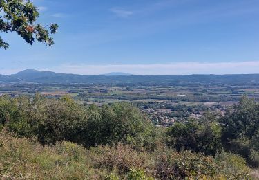
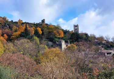
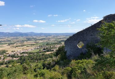
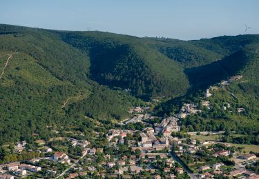
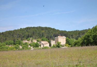
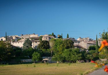
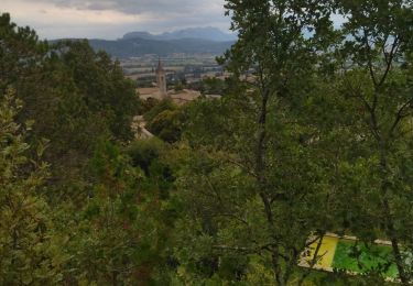
Randonnée V.T.T. de 28 km à découvrir à Auvergne-Rhône-Alpes, Drôme, Marsanne. Cette randonnée est proposée par charlytan.
Description
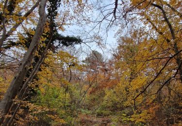
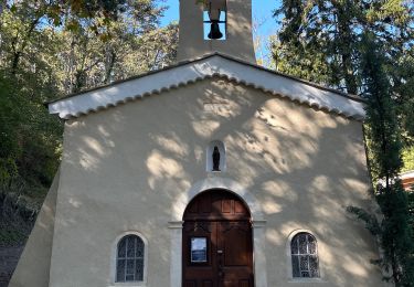
Cet itinéraire prend rapidement de la hauteur en grimpant sur les hauteurs de Marsanne, au niveau des ruines de la chapelle Saint-Félix avant de poursuivre sur un sentir en forêt, longeant la montagne. Le retour par la plaine est plus doux et plat.
Localisation
Pays :
France
Région :
Auvergne-Rhône-Alpes
Département/Province :
Drôme
Commune :
Marsanne
Localité :
Unknown
Départ:(Dec)
Départ:(UTM)
648782 ; 4944978 (31T) N.
Commentaires
Randonnées à proximité
![Randonnée Marche Sauzet - Sauzet Les Grands Abris 7km5 - Photo](https://media.geolcdn.com/t/375/260/dc904df7-2d15-4473-9afc-0180c6e306df.jpg&format=jpg&maxdim=2)
![Marche Marche](https://static1.geolcdn.com/sitytour/trail-icons/101.png)
Sauzet Les Grands Abris 7km5
Marche
Moyen
(1)
Sauzet,
Auvergne-Rhône-Alpes,
Drôme,
France
![](/images/other/stat-length.png)
7,3 km | 11,7 km-effort
2h 26min
![](https://static1.geolcdn.com/siteimages/upload/files/16400158638029165_repeat_loop_refresh_sync_direction_icon.png)
Oui
![Randonnée Marche Marsanne - Marsanne Les Fileuses 11km - Photo](https://media.geolcdn.com/t/375/260/1bc76543-3f04-4843-8b57-1b794a10099f.jpg&format=jpg&maxdim=2)
![Marche Marche](https://static1.geolcdn.com/sitytour/trail-icons/101.png)
Marsanne Les Fileuses 11km
Marche
Difficile
Marsanne,
Auvergne-Rhône-Alpes,
Drôme,
France
![](/images/other/stat-length.png)
10 km | 14,5 km-effort
3h 17min
![](https://static1.geolcdn.com/siteimages/upload/files/16400158638029165_repeat_loop_refresh_sync_direction_icon.png)
Oui
![Randonnée Marche Marsanne - Marsanne . Les extrêmes 23km - Photo](https://media.geolcdn.com/t/375/260/7e7a370b-6dd4-40a2-9fe9-e7b41d047702.jpg&format=jpg&maxdim=2)
![Marche Marche](https://static1.geolcdn.com/sitytour/trail-icons/101.png)
Marsanne . Les extrêmes 23km
Marche
Très difficile
Marsanne,
Auvergne-Rhône-Alpes,
Drôme,
France
![](/images/other/stat-length.png)
23 km | 33 km-effort
7h 34min
![](https://static1.geolcdn.com/siteimages/upload/files/16400158638029165_repeat_loop_refresh_sync_direction_icon.png)
Oui
![Randonnée Marche Marsanne - Le Serre de Paturel 4km5 - Photo](https://media.geolcdn.com/t/375/260/6920fa6a-09c5-442d-bdb3-dc0abd5d0470.jpg&format=jpg&maxdim=2)
![Marche Marche](https://static1.geolcdn.com/sitytour/trail-icons/101.png)
Le Serre de Paturel 4km5
Marche
Moyen
Marsanne,
Auvergne-Rhône-Alpes,
Drôme,
France
![](/images/other/stat-length.png)
4,4 km | 7,5 km-effort
1h 42min
![](https://static1.geolcdn.com/siteimages/upload/files/16400158638029165_repeat_loop_refresh_sync_direction_icon.png)
Oui
![Randonnée Marche Condillac - Condillac Borne Rousse et le Grand Travers 11km - Photo](https://media.geolcdn.com/t/375/260/682fa6c2-f9ec-4b30-ade4-a125a2ae7aa0.jpg&format=jpg&maxdim=2)
![Marche Marche](https://static1.geolcdn.com/sitytour/trail-icons/101.png)
Condillac Borne Rousse et le Grand Travers 11km
Marche
Moyen
Condillac,
Auvergne-Rhône-Alpes,
Drôme,
France
![](/images/other/stat-length.png)
10,6 km | 16,3 km-effort
3h 41min
![](https://static1.geolcdn.com/siteimages/upload/files/16400158638029165_repeat_loop_refresh_sync_direction_icon.png)
Oui
![Randonnée Marche Sauzet - Les Grands Abris 7km - Photo](https://media.geolcdn.com/t/375/260/7a0f940a-b445-4320-8788-dc8b4c52f3c2.jpg&format=jpg&maxdim=2)
![Marche Marche](https://static1.geolcdn.com/sitytour/trail-icons/101.png)
Les Grands Abris 7km
Marche
Moyen
Sauzet,
Auvergne-Rhône-Alpes,
Drôme,
France
![](/images/other/stat-length.png)
7,3 km | 11,8 km-effort
2h 40min
![](https://static1.geolcdn.com/siteimages/upload/files/16400158638029165_repeat_loop_refresh_sync_direction_icon.png)
Oui
![Randonnée Marche Marsanne - 26 marsanne - Photo](https://media.geolcdn.com/t/375/260/eb9e8457-8b6e-43e2-b07d-70d6ea2ee458.jpg&format=jpg&maxdim=2)
![Marche Marche](https://static1.geolcdn.com/sitytour/trail-icons/101.png)
26 marsanne
Marche
Moyen
Marsanne,
Auvergne-Rhône-Alpes,
Drôme,
France
![](/images/other/stat-length.png)
21 km | 30 km-effort
5h 43min
![](https://static1.geolcdn.com/siteimages/upload/files/16400158638029165_repeat_loop_refresh_sync_direction_icon.png)
Oui
![Randonnée Marche Marsanne - Marsanne la Teissonnière 10km. - Photo](https://media.geolcdn.com/t/375/260/3bf0be89-93ab-4fe5-ab65-545a02c9fe31.jpg&format=jpg&maxdim=2)
![Marche Marche](https://static1.geolcdn.com/sitytour/trail-icons/101.png)
Marsanne la Teissonnière 10km.
Marche
Difficile
Marsanne,
Auvergne-Rhône-Alpes,
Drôme,
France
![](/images/other/stat-length.png)
9,7 km | 14,2 km-effort
3h 13min
![](https://static1.geolcdn.com/siteimages/upload/files/16400158638029165_repeat_loop_refresh_sync_direction_icon.png)
Oui
![Randonnée sport Marsanne - Marsanne grande limite ND Fresneau - Photo](https://media.geolcdn.com/t/375/260/0900e885-54f4-4782-b307-7bbe8bc15844.jpg&format=jpg&maxdim=2)
Marsanne grande limite ND Fresneau
sport
Très facile
Marsanne,
Auvergne-Rhône-Alpes,
Drôme,
France
![](/images/other/stat-length.png)
14,2 km | 21 km-effort
Inconnu
![](https://static1.geolcdn.com/siteimages/upload/files/16400158638029165_repeat_loop_refresh_sync_direction_icon.png)
Oui