Randonnée V.T.T. Puygiron - PIERRE ROUSSE - Puygiron (26 Drome) - Photo

PIERRE ROUSSE - Puygiron (26 Drome)

 charlytan
charlytan

Utilisateur

© OpenStreetMap contributors
Longueur
Longueur
12,4 km
Altitude max
Altitude max
265 m
Dénivelé positif
Dénivelé positif
236 m
Km-Effort
Km-Effort  
15,5 km
Altitude min
Altitude min
149 m
Dénivelé négatif
Dénivelé négatif
238 m
Boucle
Boucle
Oui
Date de création :
2021-07-08 14:04:26.317
Dernière modification :
2021-08-20 12:01:27.262

(0 Avis)

V.T.T.
V.T.T.
--
Difficulté : Inconnu

Scannez ce code QR pour ouvrir la randonnée dans l'application SityTrail

Application GPS de randonnée GRATUITE

Logo SityTrail SityTrail

IGN / Instituts géographiques

Télécharger SityTrail sur l'App Store Télécharger SityTrail sur Google Play

Logo SityTrail SityTrail World

Le monde est à vous

Télécharger SityTrail sur l'App Store Télécharger SityTrail sur Google Play Télécharger SityTrail sur Huawei AppGallery

À propos

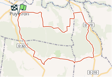
Randonnée V.T.T. de 12,4 km à découvrir à Auvergne-Rhône-Alpes, Drôme, Puygiron. Cette randonnée est proposée par charlytan.

Description

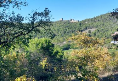
Commencez ce circuit au coeur de Puygiron où est niché un château du XIIe siècle classé. Un belvédère de choix, surplombant la plaine de la Valdaine et les anciennes ruelles du village. Poursuivez par de petits sentiers en forêts, ombragés et paisibles.

Profil altimétrique

Localisation

Pays :
France
Région :
Auvergne-Rhône-Alpes
Département/Province :
Drôme
Commune :
Puygiron
Localité :
Unknown
Départ:(Dec)
Départ:(UTM)
646809 ; 4933800 (31T) N.

Randonnées à proximité

Randonnée Marche Portes-en-Valdaine - Portes en Valdaine la plaine 7km - Photo
Marche
GUIDE
thonyc

Marche

Facile
(1)
Portes-en-Valdaine, Auvergne-Rhône-Alpes, Drôme, France
7,1 km | 8,2 km-effort
2h 0min
Oui
Randonnée Marche Allan - allan transclavienne rac - Photo
Marche
micheleuvrard

Marche

Très facile
(1)
Allan, Auvergne-Rhône-Alpes, Drôme, France
19,1 km | 26 km-effort
5h 11min
Oui
Randonnée V.T.T. Puygiron - Puygiron VTT n°5 - Photo
V.T.T.
tracegps

V.T.T.

Très difficile
(1)
Puygiron, Auvergne-Rhône-Alpes, Drôme, France
47 km | 60 km-effort
3h 0min
Oui
Randonnée Marche La Touche - La Touche Crêtes de l'ysard 12km. - Photo
Marche
chancha

Marche

Difficile
(1)
La Touche, Auvergne-Rhône-Alpes, Drôme, France
12,1 km | 16,8 km-effort
3h 48min
Oui
Randonnée Marche Portes-en-Valdaine - 26 portes en valdaine - Photo
Marche
GUIDE
randodyssée

Marche

Très facile
Portes-en-Valdaine, Auvergne-Rhône-Alpes, Drôme, France
10,6 km | 14,5 km-effort
4h 10min
Oui
Randonnée Marche La Touche - Citelles hameau et ruisseaux 10km - Photo
Marche
GUIDE
thonyc

Marche

Facile
(2)
La Touche, Auvergne-Rhône-Alpes, Drôme, France
9,6 km | 12,6 km-effort
3h 7min
Oui
Randonnée sport Allan - SityTrail - Les Villages Perchés. - Photo
sport
collot

sport

Très facile
(1)
Allan, Auvergne-Rhône-Alpes, Drôme, France
19,5 km | 27 km-effort
Inconnu
Oui
Randonnée Marche Puygiron - 26 Puygiron au coucher du soleil  - Photo
Marche
Maryma

Marche

Moyen
Puygiron, Auvergne-Rhône-Alpes, Drôme, France
5,7 km | 8,1 km-effort
1h 50min
Oui
Randonnée Marche Montboucher-sur-Jabron - 20240428 Rando vieux  - Photo
Marche
Havani

Marche

Très facile
Montboucher-sur-Jabron, Auvergne-Rhône-Alpes, Drôme, France
6,1 km | 6,5 km-effort
5h 17min
Oui


Fermer
Mes abonnements