![](/images/other/stat-length.png)
![Randonnée V.T.T. Leucate - port leucate la franqui - Photo](https://media.geolcdn.com/t/1900/400/ext.pjpeg?maxdim=2&url=https%3A%2F%2Fstatic1.geolcdn.com%2Fsiteimages%2Fupload%2Ffiles%2F1524743154velo.jpg)
port leucate la franqui
Brusa
Utilisateur
![Longueur](/images/other/stat-length.png)
Longueur
31 km
![Altitude max](https://static1.geolcdn.com/siteimages/upload/files/1508320355ic_sort_altitude_max_24dp.png)
Altitude max
52 m
![Dénivelé positif](https://static1.geolcdn.com/siteimages/upload/files/1508320355ic_sort_den_pos_24dp.png)
Dénivelé positif
255 m
![Km-Effort](/images/other/stat-length.png)
Km-Effort
34 km
![Altitude min](https://static1.geolcdn.com/siteimages/upload/files/1508320355ic_sort_altitude_min_24dp.png)
Altitude min
-3 m
![Dénivelé négatif](https://static1.geolcdn.com/siteimages/upload/files/1508320355ic_sort_den_neg_24dp.png)
Dénivelé négatif
254 m
![Boucle](https://static1.geolcdn.com/siteimages/upload/files/16400158638029165_repeat_loop_refresh_sync_direction_icon.png)
Boucle
Oui
Date de création :
2014-12-10 00:00:00.0
Dernière modification :
2014-12-10 00:00:00.0
![V.T.T.](https://static1.geolcdn.com/sitytour/trail-icons/202.png)
2h41
Difficulté : Facile
![Scannez ce code QR pour ouvrir la randonnée dans l'application SityTrail](https://capi.geolives.com/qq0zvz2zws4bq2lad0pu/sitytour/trails/285084/qr.png?size=200)
Application GPS de randonnée GRATUITE
À propos
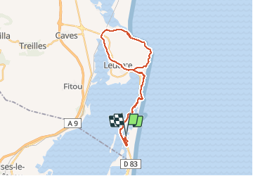
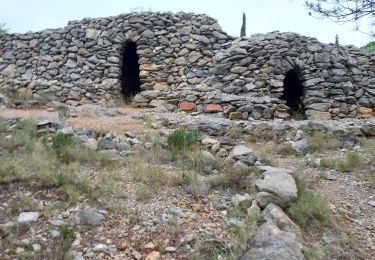
Randonnée V.T.T. de 31 km à découvrir à Occitanie, Aude, Leucate. Cette randonnée est proposée par Brusa.
Description
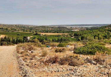
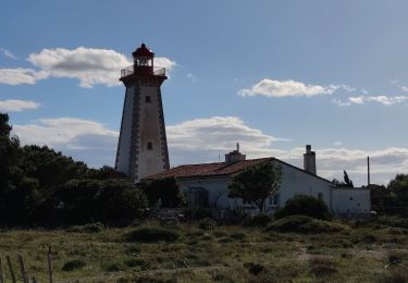
Départ du Quai des Dosses à Port-Leucate, montée sur le pont puis traversée du village de Leucate pour aller à la falaise de La Franqui. Retour par la route du phare vers Port-Leucate avec un arrêt au Grau de Leucate pour déguster des huitres.
Localisation
Pays :
France
Région :
Occitanie
Département/Province :
Aude
Commune :
Leucate
Localité :
Unknown
Départ:(Dec)
Départ:(UTM)
502877 ; 4745102 (31T) N.
Commentaires
Randonnées à proximité
![Randonnée Marche Fitou - fitou peage - Photo](https://media.geolcdn.com/t/375/260/9f029174-17d2-44b3-b33d-e5d7f852505f.jpg&format=jpg&maxdim=2)
![Marche Marche](https://static1.geolcdn.com/sitytour/trail-icons/101.png)
![Randonnée Marche Fitou - Fitou TBG - Photo](https://media.geolcdn.com/t/375/260/dc824ccb-ca31-46bc-99ed-04779b1a4f62.jpg&format=jpg&maxdim=2)
![Marche Marche](https://static1.geolcdn.com/sitytour/trail-icons/101.png)
![Randonnée V.T.T. Leucate - Phare Leucate - Photo](https://media.geolcdn.com/t/375/260/48929f4a-e8ab-45db-bafb-e5c914f82af3.jpg&format=jpg&maxdim=2)
![V.T.T. V.T.T.](https://static1.geolcdn.com/sitytour/trail-icons/202.png)
![Randonnée V.T.T. Fitou - Randonnée VTT sur Fitou - Photo](https://media.geolcdn.com/t/375/260/ext.jpg?maxdim=2&url=https%3A%2F%2Fservices.sitytrail.com%2FGeolivesWS%2FDownloadMedia.ashx%3FTrailID%3D105318%26Media%3D9009_2.jpg)
![V.T.T. V.T.T.](https://static1.geolcdn.com/sitytour/trail-icons/202.png)
Randonnée VTT sur Fitou
V.T.T.
Difficile
Fitou,
Occitanie,
Aude,
France
![](/images/other/stat-length.png)
39 km | 49 km-effort
2h 30min
![](https://static1.geolcdn.com/siteimages/upload/files/16400158638029165_repeat_loop_refresh_sync_direction_icon.png)
Oui
![Randonnée Marche Le Barcarès - dosse 12 nov - Photo](https://media.geolcdn.com/t/375/260/ext.jpg?maxdim=2&url=https%3A%2F%2Fstatic1.geolcdn.com%2Fsiteimages%2Fupload%2Ffiles%2F1553511878bg_sport_marche.png)
![Marche Marche](https://static1.geolcdn.com/sitytour/trail-icons/101.png)
dosse 12 nov
Marche
Facile
Le Barcarès,
Occitanie,
Pyrénées-Orientales,
France
![](/images/other/stat-length.png)
4,5 km | 4,8 km-effort
2h 6min
![](https://static1.geolcdn.com/siteimages/upload/files/16400158638029165_repeat_loop_refresh_sync_direction_icon.png)
Oui
![Randonnée Marche Le Barcarès - 10 oct 2024 - Photo](https://media.geolcdn.com/t/375/260/ext.jpg?maxdim=2&url=https%3A%2F%2Fstatic1.geolcdn.com%2Fsiteimages%2Fupload%2Ffiles%2F1553511878bg_sport_marche.png)
![Marche Marche](https://static1.geolcdn.com/sitytour/trail-icons/101.png)
10 oct 2024
Marche
Facile
Le Barcarès,
Occitanie,
Pyrénées-Orientales,
France
![](/images/other/stat-length.png)
4,3 km | 4,6 km-effort
1h 20min
![](https://static1.geolcdn.com/siteimages/upload/files/16400158638029165_repeat_loop_refresh_sync_direction_icon.png)
Oui
![Randonnée Marche Fitou - Fitou circuit des capitelles - Photo](https://media.geolcdn.com/t/375/260/567249f3-bd2b-4287-b722-c1307cf2ed83.jpg&format=jpg&maxdim=2)
![Marche Marche](https://static1.geolcdn.com/sitytour/trail-icons/101.png)
Fitou circuit des capitelles
Marche
Moyen
(1)
Fitou,
Occitanie,
Aude,
France
![](/images/other/stat-length.png)
8,9 km | 11,7 km-effort
2h 11min
![](https://static1.geolcdn.com/siteimages/upload/files/16400158638029165_repeat_loop_refresh_sync_direction_icon.png)
Oui
![Randonnée Marche Fitou - firou capitelles - Photo](https://media.geolcdn.com/t/375/260/ext.jpg?maxdim=2&url=https%3A%2F%2Fstatic1.geolcdn.com%2Fsiteimages%2Fupload%2Ffiles%2F1553511878bg_sport_marche.png)
![Marche Marche](https://static1.geolcdn.com/sitytour/trail-icons/101.png)
firou capitelles
Marche
Difficile
Fitou,
Occitanie,
Aude,
France
![](/images/other/stat-length.png)
10,9 km | 14 km-effort
5h 43min
![](https://static1.geolcdn.com/siteimages/upload/files/16400158638029165_repeat_loop_refresh_sync_direction_icon.png)
Oui
![Randonnée Marche Leucate - leucate moutic - Photo](https://media.geolcdn.com/t/375/260/ext.jpg?maxdim=2&url=https%3A%2F%2Fstatic1.geolcdn.com%2Fsiteimages%2Fupload%2Ffiles%2F1553511878bg_sport_marche.png)
![Marche Marche](https://static1.geolcdn.com/sitytour/trail-icons/101.png)