![](/images/other/stat-length.png)
![Randonnée Marche Coaraze - coaraze Baisse de la Buse + de 10KM - Photo](https://media.geolcdn.com/t/1900/400/67d818b6-497f-4ac1-a6b6-f1dda0adbd1b.jpg&format=pjpeg&maxdim=2)
coaraze Baisse de la Buse + de 10KM
Renefrt
Utilisateur
![Longueur](/images/other/stat-length.png)
![Altitude max](https://static1.geolcdn.com/siteimages/upload/files/1508320355ic_sort_altitude_max_24dp.png)
![Dénivelé positif](https://static1.geolcdn.com/siteimages/upload/files/1508320355ic_sort_den_pos_24dp.png)
![Km-Effort](/images/other/stat-length.png)
![Altitude min](https://static1.geolcdn.com/siteimages/upload/files/1508320355ic_sort_altitude_min_24dp.png)
![Dénivelé négatif](https://static1.geolcdn.com/siteimages/upload/files/1508320355ic_sort_den_neg_24dp.png)
![Boucle](https://static1.geolcdn.com/siteimages/upload/files/16400158638029165_repeat_loop_refresh_sync_direction_icon.png)
![Marche](https://static1.geolcdn.com/sitytour/trail-icons/101.png)
8h05
Difficulté : Moyen
![Scannez ce code QR pour ouvrir la randonnée dans l'application SityTrail](https://capi.geolives.com/qq0zvz2zws4bq2lad0pu/sitytour/trails/2846163/qr.png?size=200)
Application GPS de randonnée GRATUITE
À propos
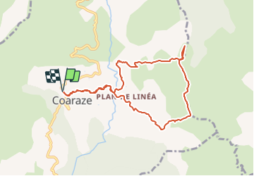
Randonnée Marche de 9 km à découvrir à Provence-Alpes-Côte d'Azur, Alpes-Maritimes, Coaraze. Cette randonnée est proposée par Renefrt.
Description
LA PHOTO DU PARCOURS QUI EST EN APERÇU N'EST BONNE ELLE NE CORRESPOND PAS AU TRACE.
Attention descente de Coaraze pas trop bonne sur des dunes de pierres à ciment, rester plutôt sur le tracer du retour sur la gauche.
Attention au départ c'est entre la rue qui monte au parking (en construction) et une maison, pas signalé.
A ma baisse de Busia le début du chemin du retour n'est pas balisé.
Très peut de signalisation sur cette randonnée
Localisation
Commentaires
Randonnées à proximité
![Randonnée A pied Coaraze - Rocca Sparvièra - Photo](https://media.geolcdn.com/t/375/260/b70c2ec2-277e-4b66-a927-a7ae11b9ea3a.jpeg&format=jpg&maxdim=2)
![A pied A pied](https://static1.geolcdn.com/sitytour/trail-icons/100.png)
A pied
![](/images/other/stat-length.png)
![](https://static1.geolcdn.com/siteimages/upload/files/16400158638029165_repeat_loop_refresh_sync_direction_icon.png)
![Randonnée A pied Utelle - Gorges de la Vésubie - Photo](https://media.geolcdn.com/t/375/260/0a667b03-3170-487d-a7f5-45b846bd9fdf.jpeg&format=jpg&maxdim=2)
![A pied A pied](https://static1.geolcdn.com/sitytour/trail-icons/100.png)
A pied
![](/images/other/stat-length.png)
![](https://static1.geolcdn.com/siteimages/upload/files/16400158638029165_repeat_loop_refresh_sync_direction_icon.png)
![Randonnée Marche Duranus - Rocca Sparviera Rocca Siera - Photo](https://media.geolcdn.com/t/375/260/cfa7ac61-c812-43a1-a04c-577e01c4a8ee.jpg&format=jpg&maxdim=2)
![Marche Marche](https://static1.geolcdn.com/sitytour/trail-icons/101.png)
Marche
![](/images/other/stat-length.png)
![](https://static1.geolcdn.com/siteimages/upload/files/16400158638029165_repeat_loop_refresh_sync_direction_icon.png)
![Randonnée Marche Coaraze - Rocca Spavierra - Photo](https://media.geolcdn.com/t/375/260/ext.jpg?maxdim=2&url=https%3A%2F%2Fstatic1.geolcdn.com%2Fsiteimages%2Fupload%2Ffiles%2F1553511878bg_sport_marche.png)
![Marche Marche](https://static1.geolcdn.com/sitytour/trail-icons/101.png)
Marche
![](/images/other/stat-length.png)
![](https://static1.geolcdn.com/siteimages/upload/files/16400158638029165_repeat_loop_refresh_sync_direction_icon.png)
![Randonnée Marche L'Escarène - L’Escarene - Photo](https://media.geolcdn.com/t/375/260/471a6d65-ba9a-4a94-ae56-e041c5f1c486.jpg&format=jpg&maxdim=2)
![Marche Marche](https://static1.geolcdn.com/sitytour/trail-icons/101.png)
Marche
![](/images/other/stat-length.png)
![](https://static1.geolcdn.com/siteimages/upload/files/16400158638029165_repeat_loop_refresh_sync_direction_icon.png)
![Randonnée Marche Utelle - Cros d Utelle chapelle St Antoine - Photo](https://media.geolcdn.com/t/375/260/ccd5b578-c9f1-437b-9e91-d8a2d45b6420.jpg&format=jpg&maxdim=2)
![Marche Marche](https://static1.geolcdn.com/sitytour/trail-icons/101.png)
Marche
![](/images/other/stat-length.png)
![](https://static1.geolcdn.com/siteimages/upload/files/16400158638029165_repeat_loop_refresh_sync_direction_icon.png)
![Marche Marche](https://static1.geolcdn.com/sitytour/trail-icons/101.png)
Marche
![](/images/other/stat-length.png)
![](https://static1.geolcdn.com/siteimages/upload/files/16400158638029165_repeat_loop_refresh_sync_direction_icon.png)
![Randonnée Marche Levens - Crête du Férion 1412m 17-04-22 - Photo](https://media.geolcdn.com/t/375/260/d630ef2c-0149-421b-9b71-c0805c57034c.jpg&format=jpg&maxdim=2)
![Marche Marche](https://static1.geolcdn.com/sitytour/trail-icons/101.png)
Marche
![](/images/other/stat-length.png)
![](https://static1.geolcdn.com/siteimages/upload/files/16400158638029165_repeat_loop_refresh_sync_direction_icon.png)
![Randonnée A pied Levens - Crête du Férion - Photo](https://media.geolcdn.com/t/375/260/d2999666-b0d9-4a97-b6d4-103e7aa801ec.jpeg&format=jpg&maxdim=2)
![A pied A pied](https://static1.geolcdn.com/sitytour/trail-icons/100.png)
A pied
![](/images/other/stat-length.png)
![](https://static1.geolcdn.com/siteimages/upload/files/16400158638029165_repeat_loop_refresh_sync_direction_icon.png)
comment faire pour la modifier car oublié d'éteindre l'application