![](/images/other/stat-length.png)
![Randonnée Marche Eijsden-Margraten - Sint-Geertruid_860 - Photo](https://media.geolcdn.com/t/1900/400/b99ab750-453c-46e9-b978-bdde0c882866.jpg&format=pjpeg&maxdim=2)
Sint-Geertruid_860
mumu.larandonneuse
Utilisateur GUIDE
![Longueur](/images/other/stat-length.png)
![Altitude max](https://static1.geolcdn.com/siteimages/upload/files/1508320355ic_sort_altitude_max_24dp.png)
![Dénivelé positif](https://static1.geolcdn.com/siteimages/upload/files/1508320355ic_sort_den_pos_24dp.png)
![Km-Effort](/images/other/stat-length.png)
![Altitude min](https://static1.geolcdn.com/siteimages/upload/files/1508320355ic_sort_altitude_min_24dp.png)
![Dénivelé négatif](https://static1.geolcdn.com/siteimages/upload/files/1508320355ic_sort_den_neg_24dp.png)
![Boucle](https://static1.geolcdn.com/siteimages/upload/files/16400158638029165_repeat_loop_refresh_sync_direction_icon.png)
![Marche](https://static1.geolcdn.com/sitytour/trail-icons/101.png)
4h37
Difficulté : Facile
![Scannez ce code QR pour ouvrir la randonnée dans l'application SityTrail](https://capi.geolives.com/qq0zvz2zws4bq2lad0pu/sitytour/trails/2845770/qr.png?size=200)
Application GPS de randonnée GRATUITE
À propos
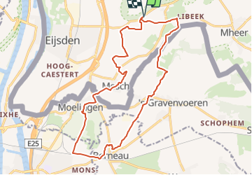
Randonnée Marche de 17,4 km à découvrir à Limbourg, Inconnu, Eijsden-Margraten. Cette randonnée est proposée par mumu.larandonneuse.
Description
ℹ Gpx pris sur www.wandelgidszuidlimburg.com n° 860.
➡️ Au cours de cette randonnée vallonnée et transfrontalière, vous montez un beau sentier jusqu'au hameau de Libeek puis vous entrez dans la région de Voer. Vous arrivez brièvement à 's Gravenvoeren puis à travers champs jusqu'à la ville francophone de Berneau, où vous pourrez prendre un verre sur la terrasse de l'hôtel Berneau ou un peu plus loin à la Taverne de la Longue Vue. Le chemin du retour passe par un beau plateau jusqu'au village de Moelingen et par une route de campagne vous atteignez le village de Mesch. Par de jolis sentiers et chemins de campagne, vous retournerez à la cafétéria avec une belle terrasse. Apportez vos propres provisions. Le parcours offre de nombreux points de vue. Vous pouvez raccourcir le parcours à 11,6 km.
Localisation
Commentaires
Randonnées à proximité
![Randonnée Marche Visé - montagne saint pierre - Photo](https://media.geolcdn.com/t/375/260/ext.jpg?maxdim=2&url=https%3A%2F%2Fservices.sitytrail.com%2FGeolivesWS%2FDownloadMedia.ashx%3FTrailID%3D308205%26Media%3D20140601165318.jpg)
![Marche Marche](https://static1.geolcdn.com/sitytour/trail-icons/101.png)
Marche
![](/images/other/stat-length.png)
![](https://static1.geolcdn.com/siteimages/upload/files/16400158638029165_repeat_loop_refresh_sync_direction_icon.png)
![Randonnée Marche Eijsden-Margraten - Mheer MH1 - Photo](https://media.geolcdn.com/t/375/260/1dd6d074-f00f-48cf-a4e6-d95117778ebf.jpg&format=jpg&maxdim=2)
![Marche Marche](https://static1.geolcdn.com/sitytour/trail-icons/101.png)
Marche
![](/images/other/stat-length.png)
![](https://static1.geolcdn.com/siteimages/upload/files/16400158638029165_repeat_loop_refresh_sync_direction_icon.png)
![Randonnée Marche Eijsden-Margraten - Mheer - Banholt - Hoogbos - Photo](https://media.geolcdn.com/t/375/260/1f70cdf1-9a0b-4d25-acc7-7c75993bbb86.jpg&format=jpg&maxdim=2)
![Marche Marche](https://static1.geolcdn.com/sitytour/trail-icons/101.png)
Marche
![](/images/other/stat-length.png)
![](https://static1.geolcdn.com/siteimages/upload/files/16400158638029165_repeat_loop_refresh_sync_direction_icon.png)
![Randonnée Marche Eijsden-Margraten - Eijsden - E8 - Bloesemroute-3 - Photo](https://media.geolcdn.com/t/375/260/7792b7db-95a9-4b53-8cd5-7eae3fedc6a4.jpg&format=jpg&maxdim=2)
![Marche Marche](https://static1.geolcdn.com/sitytour/trail-icons/101.png)
Marche
![](/images/other/stat-length.png)
![](https://static1.geolcdn.com/siteimages/upload/files/16400158638029165_repeat_loop_refresh_sync_direction_icon.png)
![Randonnée Marche Eijsden-Margraten - Mesch [Eijsden - E5] - Photo](https://media.geolcdn.com/t/375/260/cb3c0103-7b73-4049-ab47-8594df511d3c.jpg&format=jpg&maxdim=2)
![Marche Marche](https://static1.geolcdn.com/sitytour/trail-icons/101.png)
Marche
![](/images/other/stat-length.png)
![](https://static1.geolcdn.com/siteimages/upload/files/16400158638029165_repeat_loop_refresh_sync_direction_icon.png)
![Randonnée Marche Eijsden-Margraten - Eijsden - Savelbos - Photo](https://media.geolcdn.com/t/375/260/1a835e4b-4203-472e-b4f4-bdf046d29220.jpg&format=jpg&maxdim=2)
![Marche Marche](https://static1.geolcdn.com/sitytour/trail-icons/101.png)
Marche
![](/images/other/stat-length.png)
![](https://static1.geolcdn.com/siteimages/upload/files/16400158638029165_repeat_loop_refresh_sync_direction_icon.png)
![Randonnée Marche Fourons - Wandelroute-de-voerstreek-mooiste - Photo](https://media.geolcdn.com/t/375/260/3df743f8-88e4-4c10-a47a-c05fdf0072fe.jpg&format=jpg&maxdim=2)
![Marche Marche](https://static1.geolcdn.com/sitytour/trail-icons/101.png)
Marche
![](/images/other/stat-length.png)
![](https://static1.geolcdn.com/siteimages/upload/files/16400158638029165_repeat_loop_refresh_sync_direction_icon.png)
![Randonnée Marche Eijsden-Margraten - Gronsveld_1327 - Photo](https://media.geolcdn.com/t/375/260/877eed2d-204c-4212-a49e-caf4fc574b56.jpg&format=jpg&maxdim=2)
![Marche Marche](https://static1.geolcdn.com/sitytour/trail-icons/101.png)
Marche
![](/images/other/stat-length.png)
![](https://static1.geolcdn.com/siteimages/upload/files/16400158638029165_repeat_loop_refresh_sync_direction_icon.png)
![Randonnée Marche Eijsden-Margraten - E9 - Mesch - Mouland - Photo](https://media.geolcdn.com/t/375/260/44ba086f-f486-4631-8c1f-b562699d8ecb.jpg&format=jpg&maxdim=2)
![Marche Marche](https://static1.geolcdn.com/sitytour/trail-icons/101.png)
Marche
![](/images/other/stat-length.png)
![](https://static1.geolcdn.com/siteimages/upload/files/16400158638029165_repeat_loop_refresh_sync_direction_icon.png)