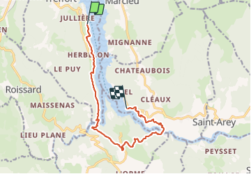
![](/images/other/stat-length.png)
![Randonnée Marche Treffort - Valgo2 - J3. : les passerelles de Monteynard - Photo](https://media.geolcdn.com/t/1900/400/80ded9ce-faa3-4fe9-b5ad-3607bd08278e.jpg&format=pjpeg&maxdim=2)
Valgo2 - J3. : les passerelles de Monteynard
ETMU5496
Utilisateur
![Longueur](/images/other/stat-length.png)
![Altitude max](https://static1.geolcdn.com/siteimages/upload/files/1508320355ic_sort_altitude_max_24dp.png)
![Dénivelé positif](https://static1.geolcdn.com/siteimages/upload/files/1508320355ic_sort_den_pos_24dp.png)
![Km-Effort](/images/other/stat-length.png)
![Altitude min](https://static1.geolcdn.com/siteimages/upload/files/1508320355ic_sort_altitude_min_24dp.png)
![Dénivelé négatif](https://static1.geolcdn.com/siteimages/upload/files/1508320355ic_sort_den_neg_24dp.png)
![Boucle](https://static1.geolcdn.com/siteimages/upload/files/16400158638029165_repeat_loop_refresh_sync_direction_icon.png)
![Marche](https://static1.geolcdn.com/sitytour/trail-icons/101.png)
2h42
Difficulté : Facile
![Scannez ce code QR pour ouvrir la randonnée dans l'application SityTrail](https://capi.geolives.com/qq0zvz2zws4bq2lad0pu/sitytour/trails/2843638/qr.png?size=200)
Application GPS de randonnée GRATUITE
À propos
Randonnée Marche de 12,4 km à découvrir à Auvergne-Rhône-Alpes, Isère, Treffort. Cette randonnée est proposée par ETMU5496.
Description
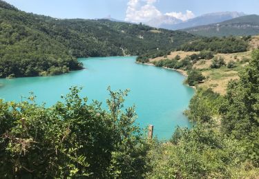
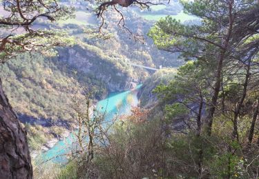
Belle escapade en Isère pour découvrir le 2e spot européen de planche à voile. Le site offre en effet 300 jours de vent par an..
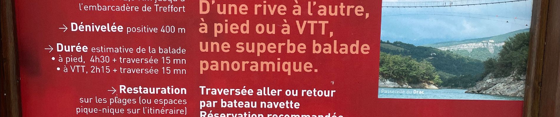
On emprunte une embarcation pour atteindre le point de départ de la randonnée. On réalise alors un parcours qui vous ramènera à la plage d'embarquement.
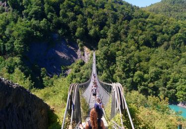
Mais la particularité de cette petite randonnée et d'emprunter deux grandes passerelles himalayennes traversant successivement le Drac et l'Ebron (sensations garanties).
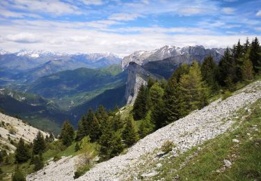
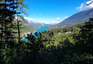
Superbe endroit !
Localisation
Commentaires
Randonnées à proximité
![Randonnée Marche Mayres-Savel - Passerelles Du Drac Et de L'Ebron - Photo](https://media.geolcdn.com/t/375/260/f4846bf3-414e-4c51-a6cb-c2da9b823649.jpg&format=jpg&maxdim=2)
![Marche Marche](https://static1.geolcdn.com/sitytour/trail-icons/101.png)
Marche
![](/images/other/stat-length.png)
![](https://static1.geolcdn.com/siteimages/upload/files/16400158638029165_repeat_loop_refresh_sync_direction_icon.png)
![Randonnée Cheval Roissard - Trieves - Devoluy - Photo](https://media.geolcdn.com/t/375/260/532091fd-ff63-40b6-9790-4b260fef3e51.jpg&format=jpg&maxdim=2)
![Cheval Cheval](https://static1.geolcdn.com/sitytour/trail-icons/300.png)
Cheval
![](/images/other/stat-length.png)
![](https://static1.geolcdn.com/siteimages/upload/files/16400158638029165_repeat_loop_refresh_sync_direction_icon.png)
![Randonnée Marche Mayres-Savel - Passerelles Hymalayene Mayres + 250 - Photo](https://media.geolcdn.com/t/375/260/e79ec6b2-c62a-43e0-95ca-91baa034bf5d.jpg&format=jpg&maxdim=2)
![Marche Marche](https://static1.geolcdn.com/sitytour/trail-icons/101.png)
Marche
![](/images/other/stat-length.png)
![](https://static1.geolcdn.com/siteimages/upload/files/16400158638029165_repeat_loop_refresh_sync_direction_icon.png)
![Randonnée Marche Treffort - ISERE: MONTEYNARD PASSERELLES HIMALAYENNES - Photo](https://media.geolcdn.com/t/375/260/76721c9b-6b33-4db9-86bf-ba7e9a8d140f.jpg&format=jpg&maxdim=2)
![Marche Marche](https://static1.geolcdn.com/sitytour/trail-icons/101.png)
Marche
![](/images/other/stat-length.png)
![](https://static1.geolcdn.com/siteimages/upload/files/16400158638029165_repeat_loop_refresh_sync_direction_icon.png)
![Randonnée Marche Mayres-Savel - Randonnée des passerelles - Photo](https://media.geolcdn.com/t/375/260/f81885ad-9d99-466e-990d-175fbd3a925e.jpg&format=jpg&maxdim=2)
![Marche Marche](https://static1.geolcdn.com/sitytour/trail-icons/101.png)
Marche
![](/images/other/stat-length.png)
![](https://static1.geolcdn.com/siteimages/upload/files/16400158638029165_repeat_loop_refresh_sync_direction_icon.png)
![Randonnée Marche La Motte-Saint-Martin - Sinepi - Photo](https://media.geolcdn.com/t/375/260/ext.jpg?maxdim=2&url=https%3A%2F%2Fstatic1.geolcdn.com%2Fsiteimages%2Fupload%2Ffiles%2F1553511878bg_sport_marche.png)
![Marche Marche](https://static1.geolcdn.com/sitytour/trail-icons/101.png)
Marche
![](/images/other/stat-length.png)
![](https://static1.geolcdn.com/siteimages/upload/files/16400158638029165_repeat_loop_refresh_sync_direction_icon.png)
![Randonnée Marche Treffort - Passerelle Drac - Photo](https://media.geolcdn.com/t/375/260/feb433be-0155-46e7-819a-3b1bb0447bc5.jpg&format=jpg&maxdim=2)
![Marche Marche](https://static1.geolcdn.com/sitytour/trail-icons/101.png)
Marche
![](/images/other/stat-length.png)
![](https://static1.geolcdn.com/siteimages/upload/files/16400158638029165_repeat_loop_refresh_sync_direction_icon.png)
![Randonnée Marche Treffort - Les deux passerelles Drac et Ebron - Photo](https://media.geolcdn.com/t/375/260/3778f66d-36c2-41c5-9e06-64b09fbd2374.jpg&format=jpg&maxdim=2)
![Marche Marche](https://static1.geolcdn.com/sitytour/trail-icons/101.png)
Marche
![](/images/other/stat-length.png)
![](https://static1.geolcdn.com/siteimages/upload/files/16400158638029165_repeat_loop_refresh_sync_direction_icon.png)
![Randonnée Marche Treffort - Passerelle de l'Ebron. pointe de la Condamine, pas de Berlioz - Photo](https://media.geolcdn.com/t/375/260/d02366ad-0139-4ee6-b13c-ef6ca7fda045.jpg&format=jpg&maxdim=2)
![Marche Marche](https://static1.geolcdn.com/sitytour/trail-icons/101.png)
Marche
![](/images/other/stat-length.png)
![](https://static1.geolcdn.com/siteimages/upload/files/16400158638029165_repeat_loop_refresh_sync_direction_icon.png)