![](/images/other/stat-length.png)
![Randonnée Vélo électrique Molières-Cavaillac - cirque de Navacelle - Photo](https://media.geolcdn.com/t/1900/400/ext.pjpeg?maxdim=2&url=https%3A%2F%2Fstatic1.geolcdn.com%2Fsiteimages%2Fupload%2Ffiles%2F1524743154velo.jpg)
cirque de Navacelle
martoche
Utilisateur
![Longueur](/images/other/stat-length.png)
![Altitude max](https://static1.geolcdn.com/siteimages/upload/files/1508320355ic_sort_altitude_max_24dp.png)
![Dénivelé positif](https://static1.geolcdn.com/siteimages/upload/files/1508320355ic_sort_den_pos_24dp.png)
![Km-Effort](/images/other/stat-length.png)
![Altitude min](https://static1.geolcdn.com/siteimages/upload/files/1508320355ic_sort_altitude_min_24dp.png)
![Dénivelé négatif](https://static1.geolcdn.com/siteimages/upload/files/1508320355ic_sort_den_neg_24dp.png)
![Boucle](https://static1.geolcdn.com/siteimages/upload/files/16400158638029165_repeat_loop_refresh_sync_direction_icon.png)
![Vélo électrique](https://static1.geolcdn.com/sitytour/trail-icons/205.png)
6h15
Difficulté : Difficile
![Scannez ce code QR pour ouvrir la randonnée dans l'application SityTrail](https://capi.geolives.com/qq0zvz2zws4bq2lad0pu/sitytour/trails/2840296/qr.png?size=200)
Application GPS de randonnée GRATUITE
À propos
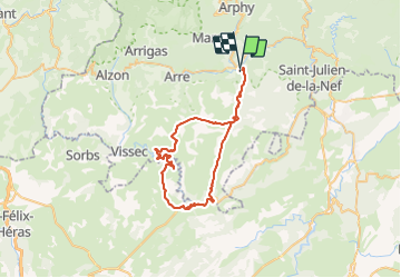
Randonnée Vélo électrique de 60 km à découvrir à Occitanie, Gard, Molières-Cavaillac. Cette randonnée est proposée par martoche.
Description
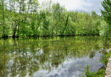
au depart du camping d'Aveze, atteindre le cirque par le Causse de Blandas. La descente est somptueuse avec des points de vues grandioses.Atteindre Navacelle, pause casse croute au bord de la Vis. Remonter en face tout aussi spectaculaire, et atteindre St Maurice de Navacelle. Descente en roue libre super jusqu'à Mediere, et là remonter 400m pour atteindre Mondrodier ( ouf!) et enfin finish en descente a fond les ballons jusqu'au camping d'Aveze.
je recommande ce magnifique circuit mais attention autonomie batterie avec 400w ça passe reste une barre 500w reste 2 barre.
Localisation
Commentaires
Randonnées à proximité
![Marche Marche](https://static1.geolcdn.com/sitytour/trail-icons/101.png)
Marche
![](/images/other/stat-length.png)
![](https://static1.geolcdn.com/siteimages/upload/files/16400158638029165_repeat_loop_refresh_sync_direction_icon.png)
![Randonnée Marche Saint-Laurent-le-Minier - Saint-Laurent-du-Minier - grotte d'Anjeau - tour du pic d'Anjeau - cascade de la Vis - Photo](https://media.geolcdn.com/t/375/260/ext.jpg?maxdim=2&url=https%3A%2F%2Fstatic1.geolcdn.com%2Fsiteimages%2Fupload%2Ffiles%2F1553511878bg_sport_marche.png)
![Marche Marche](https://static1.geolcdn.com/sitytour/trail-icons/101.png)
Marche
![](/images/other/stat-length.png)
![](https://static1.geolcdn.com/siteimages/upload/files/16400158638029165_repeat_loop_refresh_sync_direction_icon.png)
![Randonnée Marche Molières-Cavaillac - Molières-Cavaillac à Bez-et-Esparon - Photo](https://media.geolcdn.com/t/375/260/ext.jpg?maxdim=2&url=https%3A%2F%2Fservices.sitytrail.com%2FGeolivesWS%2FDownloadMedia.ashx%3FTrailID%3D227203%26Media%3Dfix__20131014115118.jpg)
![Marche Marche](https://static1.geolcdn.com/sitytour/trail-icons/101.png)
Marche
![](/images/other/stat-length.png)
![](https://static1.geolcdn.com/siteimages/upload/files/16400158638029165_repeat_loop_refresh_sync_direction_icon.png)
![Randonnée Marche Molières-Cavaillac - esparon_col Mouzoules - Photo](https://media.geolcdn.com/t/375/260/ext.jpg?maxdim=2&url=https%3A%2F%2Fstatic1.geolcdn.com%2Fsiteimages%2Fupload%2Ffiles%2F1553511878bg_sport_marche.png)
![Marche Marche](https://static1.geolcdn.com/sitytour/trail-icons/101.png)
Marche
![](/images/other/stat-length.png)
![](https://static1.geolcdn.com/siteimages/upload/files/16400158638029165_repeat_loop_refresh_sync_direction_icon.png)
![Randonnée Marche Bréau-Mars - Bréau le tour - Photo](https://media.geolcdn.com/t/375/260/04181ca0-7890-4fba-8e38-4c365efc7b61.jpg&format=jpg&maxdim=2)
![Marche Marche](https://static1.geolcdn.com/sitytour/trail-icons/101.png)
![Randonnée Marche Le Vigan - Le Vigan Nacelles GR7 - Photo](https://media.geolcdn.com/t/375/260/944fa77a-9052-4a0b-8e78-aaa140d1aa33.jpg&format=jpg&maxdim=2)
![Marche Marche](https://static1.geolcdn.com/sitytour/trail-icons/101.png)
Marche
![](/images/other/stat-length.png)
![](https://static1.geolcdn.com/siteimages/upload/files/16400158638029165_repeat_loop_refresh_sync_direction_icon.png)
![Randonnée Marche Saint-Bresson - Saint Bresson - Photo](https://media.geolcdn.com/t/375/260/15d7e237-e2dc-49a4-a22d-b2a753ce536e.jpg&format=jpg&maxdim=2)
![Marche Marche](https://static1.geolcdn.com/sitytour/trail-icons/101.png)
Marche
![](/images/other/stat-length.png)
![](https://static1.geolcdn.com/siteimages/upload/files/16400158638029165_repeat_loop_refresh_sync_direction_icon.png)
![Randonnée Marche Saint-Laurent-le-Minier - St Laurent le Minier - cascade au village et grotte de l'Enjeau - Photo](https://media.geolcdn.com/t/375/260/19a97a1d-c5d1-47a1-a832-d3d7672cf8b2.jpg&format=jpg&maxdim=2)
![Marche Marche](https://static1.geolcdn.com/sitytour/trail-icons/101.png)
Marche
![](/images/other/stat-length.png)
![](https://static1.geolcdn.com/siteimages/upload/files/16400158638029165_repeat_loop_refresh_sync_direction_icon.png)
![Randonnée Marche Le Vigan - le Vigan-la vallée de l'Arre - Photo](https://media.geolcdn.com/t/375/260/ext.jpg?maxdim=2&url=https%3A%2F%2Fservices.sitytrail.com%2FGeolivesWS%2FDownloadMedia.ashx%3FTrailID%3D362454%26Media%3Df059e141-c158-4c18-9b0d-6b8c8a751e74.JPG)
![Marche Marche](https://static1.geolcdn.com/sitytour/trail-icons/101.png)
Marche
![](/images/other/stat-length.png)
![](https://static1.geolcdn.com/siteimages/upload/files/16400158638029165_repeat_loop_refresh_sync_direction_icon.png)