![](/images/other/stat-length.png)
20210626 - Xhendelesse Balade gourmande école
pierreh01
Utilisateur GUIDE
![Longueur](/images/other/stat-length.png)
Longueur
6,5 km
![Altitude max](https://static1.geolcdn.com/siteimages/upload/files/1508320355ic_sort_altitude_max_24dp.png)
Altitude max
293 m
![Dénivelé positif](https://static1.geolcdn.com/siteimages/upload/files/1508320355ic_sort_den_pos_24dp.png)
Dénivelé positif
91 m
![Km-Effort](/images/other/stat-length.png)
Km-Effort
7,8 km
![Altitude min](https://static1.geolcdn.com/siteimages/upload/files/1508320355ic_sort_altitude_min_24dp.png)
Altitude min
241 m
![Dénivelé négatif](https://static1.geolcdn.com/siteimages/upload/files/1508320355ic_sort_den_neg_24dp.png)
Dénivelé négatif
91 m
![Boucle](https://static1.geolcdn.com/siteimages/upload/files/16400158638029165_repeat_loop_refresh_sync_direction_icon.png)
Boucle
Oui
Date de création :
2021-06-26 10:27:12.0
Dernière modification :
2021-06-26 15:00:10.565
![Marche](https://static1.geolcdn.com/sitytour/trail-icons/101.png)
3h02
Difficulté : Facile
![Scannez ce code QR pour ouvrir la randonnée dans l'application SityTrail](https://capi.geolives.com/qq0zvz2zws4bq2lad0pu/sitytour/trails/2840029/qr.png?size=200)
Application GPS de randonnée GRATUITE
À propos
Randonnée Marche de 6,5 km à découvrir à Wallonie, Liège, Herve. Cette randonnée est proposée par pierreh01.
Description
Samedi 26 juin 2021
Balade gourmande de l'école de Xhendelesse, circuit de /- 6 Km, au départ de l'école.
Météo très agréable pour une promenade en famille.
Localisation
Pays :
Belgique
Région :
Wallonie
Département/Province :
Liège
Commune :
Herve
Localité :
Unknown
Départ:(Dec)
Départ:(UTM)
696161 ; 5609506 (31U) N.
Commentaires
Randonnées à proximité
![Randonnée Marche Pepinster - RB-Lg-23_Soiron_via-racc-2 - Photo](https://media.geolcdn.com/t/375/260/ext.jpg?maxdim=2&url=https%3A%2F%2Fservices.sitytrail.com%2FGeolivesWS%2FDownloadMedia.ashx%3FTrailID%3D400856%26Media%3D1646b7fd-8650-448d-bc3d-5efa9ed8c932.jpg)
![Marche Marche](https://static1.geolcdn.com/sitytour/trail-icons/101.png)
RB-Lg-23_Soiron_via-racc-2
Marche
(8)
Pepinster,
Wallonie,
Liège,
Belgique
![](/images/other/stat-length.png)
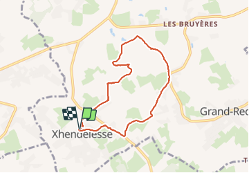
13,4 km | 17,5 km-effort
3h 58min
![](https://static1.geolcdn.com/siteimages/upload/files/16400158638029165_repeat_loop_refresh_sync_direction_icon.png)
Oui
![Randonnée Marche Pepinster - RB-Lg-23_Soiron - Photo](https://media.geolcdn.com/t/375/260/ext.jpg?maxdim=2&url=https%3A%2F%2Fservices.sitytrail.com%2FGeolivesWS%2FDownloadMedia.ashx%3FTrailID%3D400853%26Media%3D1646b7fd-8650-448d-bc3d-5efa9ed8c932.jpg)
![Marche Marche](https://static1.geolcdn.com/sitytour/trail-icons/101.png)
![Randonnée Marche Trooz - RB-Lg-03_Nessonvaux - Photo](https://media.geolcdn.com/t/375/260/ext.jpg?maxdim=2&url=https%3A%2F%2Fservices.sitytrail.com%2FGeolivesWS%2FDownloadMedia.ashx%3FTrailID%3D179559%26Media%3Dcef2de81-7d4f-4fcd-9e9d-f315370fe61f.jpg)
![Marche Marche](https://static1.geolcdn.com/sitytour/trail-icons/101.png)
RB-Lg-03_Nessonvaux
Marche
Moyen
(12)
Trooz,
Wallonie,
Liège,
Belgique
![](/images/other/stat-length.png)
22 km | 29 km-effort
6h 9min
![](https://static1.geolcdn.com/siteimages/upload/files/16400158638029165_repeat_loop_refresh_sync_direction_icon.png)
Oui
![Randonnée Marche Fléron - Retinne_1402 - Photo](https://media.geolcdn.com/t/375/260/65875cd7-f353-4090-b6ef-a8656311fae6.jpg&format=jpg&maxdim=2)
![Marche Marche](https://static1.geolcdn.com/sitytour/trail-icons/101.png)
Retinne_1402
Marche
Moyen
(1)
Fléron,
Wallonie,
Liège,
Belgique
![](/images/other/stat-length.png)
9,8 km | 12,3 km-effort
2h 47min
![](https://static1.geolcdn.com/siteimages/upload/files/16400158638029165_repeat_loop_refresh_sync_direction_icon.png)
Oui
![Randonnée Marche Herve - Thimister et son Marché de Noël 🎅🎄 alsacien 🥨 - Photo](https://media.geolcdn.com/t/375/260/3e67f0de-4933-4699-a966-0b37dcd8155f.jpg&format=jpg&maxdim=2)
![Marche Marche](https://static1.geolcdn.com/sitytour/trail-icons/101.png)
Thimister et son Marché de Noël 🎅🎄 alsacien 🥨
Marche
Facile
(1)
Herve,
Wallonie,
Liège,
Belgique
![](/images/other/stat-length.png)
12,7 km | 15,4 km-effort
2h 46min
![](https://static1.geolcdn.com/siteimages/upload/files/16400158638029165_repeat_loop_refresh_sync_direction_icon.png)
Oui
![Marche Marche](https://static1.geolcdn.com/sitytour/trail-icons/101.png)
20220919 - Herve 6 Km
Marche
Moyen
(1)
Herve,
Wallonie,
Liège,
Belgique
![](/images/other/stat-length.png)
6 km | 7,3 km-effort
1h 44min
![](https://static1.geolcdn.com/siteimages/upload/files/16400158638029165_repeat_loop_refresh_sync_direction_icon.png)
Oui
![Marche Marche](https://static1.geolcdn.com/sitytour/trail-icons/101.png)
20220603 - Herve 6.1 Km
Marche
Moyen
(1)
Herve,
Wallonie,
Liège,
Belgique
![](/images/other/stat-length.png)
6,2 km | 7,5 km-effort
1h 38min
![](https://static1.geolcdn.com/siteimages/upload/files/16400158638029165_repeat_loop_refresh_sync_direction_icon.png)
Oui
![Randonnée Marche Pepinster - Soiron n°2 - Tribomont - Wegnez - Photo](https://media.geolcdn.com/t/375/260/ec8c930a-9871-4566-956d-2a2016034199.jpg&format=jpg&maxdim=2)
![Marche Marche](https://static1.geolcdn.com/sitytour/trail-icons/101.png)
Soiron n°2 - Tribomont - Wegnez
Marche
Facile
(1)
Pepinster,
Wallonie,
Liège,
Belgique
![](/images/other/stat-length.png)
9,5 km | 12,5 km-effort
2h 50min
![](https://static1.geolcdn.com/siteimages/upload/files/16400158638029165_repeat_loop_refresh_sync_direction_icon.png)
Oui
![Marche Marche](https://static1.geolcdn.com/sitytour/trail-icons/101.png)
20220327 - Fort de Battice - 6.7 Km
Marche
Moyen
(2)
Herve,
Wallonie,
Liège,
Belgique
![](/images/other/stat-length.png)
6,3 km | 8 km-effort
2h 1min
![](https://static1.geolcdn.com/siteimages/upload/files/16400158638029165_repeat_loop_refresh_sync_direction_icon.png)
Oui