![](/images/other/stat-length.png)
![Randonnée Marche Gavarnie-Gèdre - Refuge des Espugnettes, Plateau d'Alans - Photo](https://media.geolcdn.com/t/1900/400/54513462-6232-4d6f-ae70-6d015fbf131c.jpg&format=pjpeg&maxdim=2)
Refuge des Espugnettes, Plateau d'Alans
bedous
Utilisateur
![Longueur](/images/other/stat-length.png)
Longueur
8 km
![Altitude max](https://static1.geolcdn.com/siteimages/upload/files/1508320355ic_sort_altitude_max_24dp.png)
Altitude max
2046 m
![Dénivelé positif](https://static1.geolcdn.com/siteimages/upload/files/1508320355ic_sort_den_pos_24dp.png)
Dénivelé positif
655 m
![Km-Effort](/images/other/stat-length.png)
Km-Effort
16,7 km
![Altitude min](https://static1.geolcdn.com/siteimages/upload/files/1508320355ic_sort_altitude_min_24dp.png)
Altitude min
1386 m
![Dénivelé négatif](https://static1.geolcdn.com/siteimages/upload/files/1508320355ic_sort_den_neg_24dp.png)
Dénivelé négatif
658 m
![Boucle](https://static1.geolcdn.com/siteimages/upload/files/16400158638029165_repeat_loop_refresh_sync_direction_icon.png)
Boucle
Oui
Date de création :
2021-06-25 06:52:39.485
Dernière modification :
2021-06-27 15:31:22.552
![Marche](https://static1.geolcdn.com/sitytour/trail-icons/101.png)
5h57
Difficulté : Moyen
![Scannez ce code QR pour ouvrir la randonnée dans l'application SityTrail](https://capi.geolives.com/qq0zvz2zws4bq2lad0pu/sitytour/trails/2839115/qr.png?size=200)
Application GPS de randonnée GRATUITE
À propos
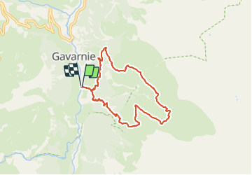
Randonnée Marche de 8 km à découvrir à Occitanie, Hautes-Pyrénées, Gavarnie-Gèdre. Cette randonnée est proposée par bedous.
Description
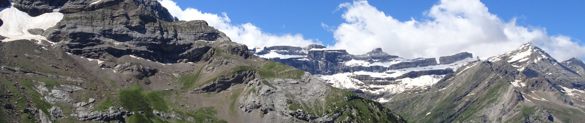
Magnifique rando avec de trés belles vues sur la brèche de Roland, un passage au refuge, le plateau avec une cabane, descente avec vue sur le cirque de Gavarnie.
Localisation
Pays :
France
Région :
Occitanie
Département/Province :
Hautes-Pyrénées
Commune :
Gavarnie-Gèdre
Localité :
Gavarnie
Départ:(Dec)
Départ:(UTM)
745017 ; 4734798 (30T) N.
Commentaires
Randonnées à proximité
![Randonnée Marche Gavarnie-Gèdre - Breche de Rolland - Photo](https://media.geolcdn.com/t/375/260/ext.jpg?maxdim=2&url=https%3A%2F%2Fservices.sitytrail.com%2FGeolivesWS%2FDownloadMedia.ashx%3FTrailID%3D334692%26Media%3Dfix__20140811120248.jpg)
![Marche Marche](https://static1.geolcdn.com/sitytour/trail-icons/101.png)
Breche de Rolland
Marche
Facile
(3)
Gavarnie-Gèdre,
Occitanie,
Hautes-Pyrénées,
France
![](/images/other/stat-length.png)
12,1 km | 22 km-effort
4h 34min
![](https://static1.geolcdn.com/siteimages/upload/files/16400158638029165_repeat_loop_refresh_sync_direction_icon.png)
Oui
![Randonnée Marche Gavarnie-Gèdre - Le Pimené par la vallée d'Estaubé - Gèbre - Photo](https://media.geolcdn.com/t/375/260/ext.jpg?maxdim=2&url=https%3A%2F%2Fservices.sitytrail.com%2FGeolivesWS%2FDownloadMedia.ashx%3FTrailID%3D316841%26Media%3D15905_6.jpg)
![Marche Marche](https://static1.geolcdn.com/sitytour/trail-icons/101.png)
Le Pimené par la vallée d'Estaubé - Gèbre
Marche
Difficile
(1)
Gavarnie-Gèdre,
Occitanie,
Hautes-Pyrénées,
France
![](/images/other/stat-length.png)
19,8 km | 35 km-effort
9h 0min
![](https://static1.geolcdn.com/siteimages/upload/files/16400158638029165_repeat_loop_refresh_sync_direction_icon.png)
Oui
![Randonnée Marche Gavarnie-Gèdre - Le Cirque de Gavarnie autrement - Photo](https://media.geolcdn.com/t/375/260/ext.jpg?maxdim=2&url=https%3A%2F%2Fservices.sitytrail.com%2FGeolivesWS%2FDownloadMedia.ashx%3FTrailID%3D103374%26Media%3D5436_6.jpg)
![Marche Marche](https://static1.geolcdn.com/sitytour/trail-icons/101.png)
Le Cirque de Gavarnie autrement
Marche
Moyen
(2)
Gavarnie-Gèdre,
Occitanie,
Hautes-Pyrénées,
France
![](/images/other/stat-length.png)
9,1 km | 15,6 km-effort
3h 0min
![](https://static1.geolcdn.com/siteimages/upload/files/16400158638029165_repeat_loop_refresh_sync_direction_icon.png)
Oui
![Randonnée Marche Gavarnie-Gèdre - Faja de las Flores - Photo](https://media.geolcdn.com/t/375/260/ext.jpg?maxdim=2&url=https%3A%2F%2Fservices.sitytrail.com%2FGeolivesWS%2FDownloadMedia.ashx%3FTrailID%3D102724%26Media%3D3837_6.jpg)
![Marche Marche](https://static1.geolcdn.com/sitytour/trail-icons/101.png)
Faja de las Flores
Marche
Très difficile
(1)
Gavarnie-Gèdre,
Occitanie,
Hautes-Pyrénées,
France
![](/images/other/stat-length.png)
22 km | 45 km-effort
13h 0min
![](https://static1.geolcdn.com/siteimages/upload/files/16400158638029165_repeat_loop_refresh_sync_direction_icon.png)
Oui
![Randonnée Marche Gavarnie-Gèdre - Le Soum Blanc des Especières 2685m depuis le col de Tentes - Photo](https://media.geolcdn.com/t/375/260/ext.jpg?maxdim=2&url=https%3A%2F%2Fservices.sitytrail.com%2FGeolivesWS%2FDownloadMedia.ashx%3FTrailID%3D109867%26Media%3D4854_1.jpg)
![Marche Marche](https://static1.geolcdn.com/sitytour/trail-icons/101.png)
Le Soum Blanc des Especières 2685m depuis le col de Tentes
Marche
Difficile
(2)
Gavarnie-Gèdre,
Occitanie,
Hautes-Pyrénées,
France
![](/images/other/stat-length.png)
5,6 km | 12,6 km-effort
3h 0min
![](https://static1.geolcdn.com/siteimages/upload/files/16400158638029165_repeat_loop_refresh_sync_direction_icon.png)
Oui
![Randonnée Marche Gavarnie-Gèdre - Le Casque du Marboré 3006m depuis le col de Tentes (2208m) - Photo](https://media.geolcdn.com/t/375/260/ext.jpg?maxdim=2&url=https%3A%2F%2Fservices.sitytrail.com%2FGeolivesWS%2FDownloadMedia.ashx%3FTrailID%3D109814%26Media%3D4776_1.jpg)
![Marche Marche](https://static1.geolcdn.com/sitytour/trail-icons/101.png)
Le Casque du Marboré 3006m depuis le col de Tentes (2208m)
Marche
Très difficile
(1)
Gavarnie-Gèdre,
Occitanie,
Hautes-Pyrénées,
France
![](/images/other/stat-length.png)
7 km | 16,4 km-effort
7h 0min
![](https://static1.geolcdn.com/siteimages/upload/files/16400158638029165_repeat_loop_refresh_sync_direction_icon.png)
Non
![Randonnée Randonnée équestre Gavarnie-Gèdre - Cirque de Gavarnie et variante - Photo](https://media.geolcdn.com/t/375/260/85d1392a-7f00-4f3f-8519-147898e5e510.jpg&format=jpg&maxdim=2)
![Randonnée équestre Randonnée équestre](https://static1.geolcdn.com/sitytour/trail-icons/301.png)
Cirque de Gavarnie et variante
Randonnée équestre
Facile
Gavarnie-Gèdre,
Occitanie,
Hautes-Pyrénées,
France
![](/images/other/stat-length.png)
29 km | 37 km-effort
3h 12min
![](https://static1.geolcdn.com/siteimages/upload/files/16400158638029165_repeat_loop_refresh_sync_direction_icon.png)
Non
![Randonnée Marche Gavarnie-Gèdre - GAVARNIE avec Pierre D, Christine et Michel Blavit 3740150 - Photo](https://media.geolcdn.com/t/375/260/dd58b21f-efc7-4d10-b038-8a72ccb92536.jpg&format=jpg&maxdim=2)
![Marche Marche](https://static1.geolcdn.com/sitytour/trail-icons/101.png)
GAVARNIE avec Pierre D, Christine et Michel Blavit 3740150
Marche
Difficile
Gavarnie-Gèdre,
Occitanie,
Hautes-Pyrénées,
France
![](/images/other/stat-length.png)
10,5 km | 17,2 km-effort
3h 53min
![](https://static1.geolcdn.com/siteimages/upload/files/16400158638029165_repeat_loop_refresh_sync_direction_icon.png)
Oui
![Randonnée Marche Gavarnie-Gèdre - PYRENNES cirque d'Estaube - Photo](https://media.geolcdn.com/t/375/260/ext.jpg?maxdim=2&url=https%3A%2F%2Fstatic1.geolcdn.com%2Fsiteimages%2Fupload%2Ffiles%2F1553511878bg_sport_marche.png)
![Marche Marche](https://static1.geolcdn.com/sitytour/trail-icons/101.png)
PYRENNES cirque d'Estaube
Marche
Moyen
(1)
Gavarnie-Gèdre,
Occitanie,
Hautes-Pyrénées,
France
![](/images/other/stat-length.png)
6,1 km | 8,6 km-effort
1h 56min
![](https://static1.geolcdn.com/siteimages/upload/files/16400158638029165_repeat_loop_refresh_sync_direction_icon.png)
Non