![](/images/other/stat-length.png)
![Randonnée Marche Orcières - Tour des lacs d'Orcières - Photo](https://media.geolcdn.com/t/1900/400/d5eb6fab-dd7d-4cc3-b386-b4daf6de524c.jpg&format=pjpeg&maxdim=2)
Tour des lacs d'Orcières
phd04
Utilisateur
![Longueur](/images/other/stat-length.png)
Longueur
13,5 km
![Altitude max](https://static1.geolcdn.com/siteimages/upload/files/1508320355ic_sort_altitude_max_24dp.png)
Altitude max
2584 m
![Dénivelé positif](https://static1.geolcdn.com/siteimages/upload/files/1508320355ic_sort_den_pos_24dp.png)
Dénivelé positif
795 m
![Km-Effort](/images/other/stat-length.png)
Km-Effort
24 km
![Altitude min](https://static1.geolcdn.com/siteimages/upload/files/1508320355ic_sort_altitude_min_24dp.png)
Altitude min
1823 m
![Dénivelé négatif](https://static1.geolcdn.com/siteimages/upload/files/1508320355ic_sort_den_neg_24dp.png)
Dénivelé négatif
795 m
![Boucle](https://static1.geolcdn.com/siteimages/upload/files/16400158638029165_repeat_loop_refresh_sync_direction_icon.png)
Boucle
Oui
Date de création :
2021-06-25 07:01:09.866
Dernière modification :
2021-06-27 09:22:00.107
![Marche](https://static1.geolcdn.com/sitytour/trail-icons/101.png)
3h48
Difficulté : Très difficile
![Scannez ce code QR pour ouvrir la randonnée dans l'application SityTrail](https://capi.geolives.com/qq0zvz2zws4bq2lad0pu/sitytour/trails/2838829/qr.png?size=200)
Application GPS de randonnée GRATUITE
À propos
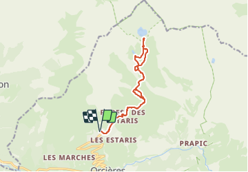
Randonnée Marche de 13,5 km à découvrir à Provence-Alpes-Côte d'Azur, Hautes-Alpes, Orcières. Cette randonnée est proposée par phd04.
Description
Très belle randonnée qui permet de découvrir tous les lacs d'Orcières sans emprunter les endroits trop fréqunetés
Localisation
Pays :
France
Région :
Provence-Alpes-Côte d'Azur
Département/Province :
Hautes-Alpes
Commune :
Orcières
Localité :
Unknown
Départ:(Dec)
Départ:(UTM)
287877 ; 4952806 (32T) N.
Commentaires
Randonnées à proximité
![Randonnée Marche Orcières - Le Forest des marches - Photo](https://media.geolcdn.com/t/375/260/1bbb2305-7ec0-44b0-abf9-1e50226e1407.jpg&format=jpg&maxdim=2)
![Marche Marche](https://static1.geolcdn.com/sitytour/trail-icons/101.png)
Le Forest des marches
Marche
Facile
(2)
Orcières,
Provence-Alpes-Côte d'Azur,
Hautes-Alpes,
France
![](/images/other/stat-length.png)
6,3 km | 9,9 km-effort
1h 42min
![](https://static1.geolcdn.com/siteimages/upload/files/16400158638029165_repeat_loop_refresh_sync_direction_icon.png)
Oui
![Randonnée Marche Orcières - R45 Marmottes a Prapic - Photo](https://media.geolcdn.com/t/375/260/9e9dbd3a-1b41-4834-8fb6-1b5270d2390e.jpg&format=jpg&maxdim=2)
![Marche Marche](https://static1.geolcdn.com/sitytour/trail-icons/101.png)
R45 Marmottes a Prapic
Marche
Moyen
(2)
Orcières,
Provence-Alpes-Côte d'Azur,
Hautes-Alpes,
France
![](/images/other/stat-length.png)
9 km | 14 km-effort
2h 57min
![](https://static1.geolcdn.com/siteimages/upload/files/16400158638029165_repeat_loop_refresh_sync_direction_icon.png)
Oui
![Randonnée Marche Orcières - Orcieres (Hautes Alpes) - Photo](https://media.geolcdn.com/t/375/260/8cda8352-22b8-4c39-b048-400b3169e428.jpg&format=jpg&maxdim=2)
![Marche Marche](https://static1.geolcdn.com/sitytour/trail-icons/101.png)
Orcieres (Hautes Alpes)
Marche
Très difficile
(1)
Orcières,
Provence-Alpes-Côte d'Azur,
Hautes-Alpes,
France
![](/images/other/stat-length.png)
12 km | 19,4 km-effort
4h 24min
![](https://static1.geolcdn.com/siteimages/upload/files/16400158638029165_repeat_loop_refresh_sync_direction_icon.png)
Oui
![Randonnée Marche Orcières - Roc Diolon par le col de Freissinières - Photo](https://media.geolcdn.com/t/375/260/5a167a74-49bc-4637-b777-9bd30e412110.jpg&format=jpg&maxdim=2)
![Marche Marche](https://static1.geolcdn.com/sitytour/trail-icons/101.png)
Roc Diolon par le col de Freissinières
Marche
Très difficile
Orcières,
Provence-Alpes-Côte d'Azur,
Hautes-Alpes,
France
![](/images/other/stat-length.png)
16,3 km | 32 km-effort
7h 21min
![](https://static1.geolcdn.com/siteimages/upload/files/16400158638029165_repeat_loop_refresh_sync_direction_icon.png)
Oui
![Randonnée Ski de randonnée Orcières - L'homme de Prapic - Photo](https://media.geolcdn.com/t/375/260/728ac5de-7771-4482-8258-55cd8c2ebd98.jpg&format=jpg&maxdim=2)
![Ski de randonnée Ski de randonnée](https://static1.geolcdn.com/sitytour/trail-icons/503.png)
L'homme de Prapic
Ski de randonnée
Moyen
Orcières,
Provence-Alpes-Côte d'Azur,
Hautes-Alpes,
France
![](/images/other/stat-length.png)
15,8 km | 33 km-effort
4h 34min
![](https://static1.geolcdn.com/siteimages/upload/files/16400158638029165_repeat_loop_refresh_sync_direction_icon.png)
Oui
![Marche Marche](https://static1.geolcdn.com/sitytour/trail-icons/101.png)
Saut du Laire
Marche
Moyen
Orcières,
Provence-Alpes-Côte d'Azur,
Hautes-Alpes,
France
![](/images/other/stat-length.png)
11,4 km | 18,9 km-effort
4h 17min
![](https://static1.geolcdn.com/siteimages/upload/files/16400158638029165_repeat_loop_refresh_sync_direction_icon.png)
Oui
![Randonnée Marche Champoléon - Méollion - Photo](https://media.geolcdn.com/t/375/260/da24cc78-a99a-4fa8-9dce-d97d6d7f39a5.jpg&format=jpg&maxdim=2)
![Marche Marche](https://static1.geolcdn.com/sitytour/trail-icons/101.png)
Méollion
Marche
Moyen
Champoléon,
Provence-Alpes-Côte d'Azur,
Hautes-Alpes,
France
![](/images/other/stat-length.png)
7,5 km | 13,7 km-effort
2h 59min
![](https://static1.geolcdn.com/siteimages/upload/files/16400158638029165_repeat_loop_refresh_sync_direction_icon.png)
Oui
![Randonnée Marche Orcières - Lac des Pisses - Photo](https://media.geolcdn.com/t/375/260/72d69359-d69b-4e79-86c6-e3022c079ec2.jpg&format=jpg&maxdim=2)
![Marche Marche](https://static1.geolcdn.com/sitytour/trail-icons/101.png)
Lac des Pisses
Marche
Difficile
Orcières,
Provence-Alpes-Côte d'Azur,
Hautes-Alpes,
France
![](/images/other/stat-length.png)
13,2 km | 26 km-effort
5h 58min
![](https://static1.geolcdn.com/siteimages/upload/files/16400158638029165_repeat_loop_refresh_sync_direction_icon.png)
Oui
![Randonnée Ski de randonnée Orcières - objectif Rocher blanc mais trop long donc direction chapeau rouge - Photo](https://media.geolcdn.com/t/375/260/7cce85a4-567c-43a2-8949-4f1bb1d57721.jpg&format=jpg&maxdim=2)
![Ski de randonnée Ski de randonnée](https://static1.geolcdn.com/sitytour/trail-icons/503.png)
objectif Rocher blanc mais trop long donc direction chapeau rouge
Ski de randonnée
Moyen
Orcières,
Provence-Alpes-Côte d'Azur,
Hautes-Alpes,
France
![](/images/other/stat-length.png)
17,2 km | 32 km-effort
6h 0min
![](https://static1.geolcdn.com/siteimages/upload/files/16400158638029165_repeat_loop_refresh_sync_direction_icon.png)
Oui