![](/images/other/stat-length.png)
![Randonnée Marche Combronde - Puy Servier - Photo](https://media.geolcdn.com/t/1900/400/ext.pjpeg?maxdim=2&url=https%3A%2F%2Fstatic1.geolcdn.com%2Fsiteimages%2Fupload%2Ffiles%2F1553511878bg_sport_marche.png)
Puy Servier
Gegetop
Utilisateur
![Longueur](/images/other/stat-length.png)
Longueur
6,3 km
![Altitude max](https://static1.geolcdn.com/siteimages/upload/files/1508320355ic_sort_altitude_max_24dp.png)
Altitude max
629 m
![Dénivelé positif](https://static1.geolcdn.com/siteimages/upload/files/1508320355ic_sort_den_pos_24dp.png)
Dénivelé positif
223 m
![Km-Effort](/images/other/stat-length.png)
Km-Effort
9,3 km
![Altitude min](https://static1.geolcdn.com/siteimages/upload/files/1508320355ic_sort_altitude_min_24dp.png)
Altitude min
418 m
![Dénivelé négatif](https://static1.geolcdn.com/siteimages/upload/files/1508320355ic_sort_den_neg_24dp.png)
Dénivelé négatif
224 m
![Boucle](https://static1.geolcdn.com/siteimages/upload/files/16400158638029165_repeat_loop_refresh_sync_direction_icon.png)
Boucle
Oui
Date de création :
2014-12-10 00:00:00.0
Dernière modification :
2014-12-10 00:00:00.0
![Marche](https://static1.geolcdn.com/sitytour/trail-icons/101.png)
2h00
Difficulté : Moyen
![Scannez ce code QR pour ouvrir la randonnée dans l'application SityTrail](https://capi.geolives.com/qq0zvz2zws4bq2lad0pu/sitytour/trails/283387/qr.png?size=200)
Application GPS de randonnée GRATUITE
À propos
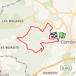
Randonnée Marche de 6,3 km à découvrir à Auvergne-Rhône-Alpes, Puy-de-Dôme, Combronde. Cette randonnée est proposée par Gegetop.
Description
Balade sympa sur les hauteurs boisées de Combronde.
Le sentier se ferme par la végétation un peu avant Combe Grand, attention donc à ne pas descendre vers le ruisseau.
Localisation
Pays :
France
Région :
Auvergne-Rhône-Alpes
Département/Province :
Puy-de-Dôme
Commune :
Combronde
Localité :
Unknown
Départ:(Dec)
Départ:(UTM)
506209 ; 5092047 (31T) N.
Commentaires
Randonnées à proximité
![Randonnée Marche Loubeyrat - Le roc du diable - Prompsat - Photo](https://media.geolcdn.com/t/375/260/ext.jpg?maxdim=2&url=https%3A%2F%2Fservices.sitytrail.com%2FGeolivesWS%2FDownloadMedia.ashx%3FTrailID%3D430823%26Media%3Dfix__20150607162607.jpg)
![Marche Marche](https://static1.geolcdn.com/sitytour/trail-icons/101.png)
Le roc du diable - Prompsat
Marche
Moyen
(1)
Loubeyrat,
Auvergne-Rhône-Alpes,
Puy-de-Dôme,
France
![](/images/other/stat-length.png)
9,5 km | 13,4 km-effort
2h 20min
![](https://static1.geolcdn.com/siteimages/upload/files/16400158638029165_repeat_loop_refresh_sync_direction_icon.png)
Oui
![Randonnée Marche Teilhède - Teilhede - Photo](https://media.geolcdn.com/t/375/260/ext.jpg?maxdim=2&url=https%3A%2F%2Fservices.sitytrail.com%2FGeolivesWS%2FDownloadMedia.ashx%3FTrailID%3D362253%26Media%3Dfix__20141031135843.jpg)
![Marche Marche](https://static1.geolcdn.com/sitytour/trail-icons/101.png)
Teilhede
Marche
Facile
(1)
Teilhède,
Auvergne-Rhône-Alpes,
Puy-de-Dôme,
France
![](/images/other/stat-length.png)
6,5 km | 8,7 km-effort
1h 38min
![](https://static1.geolcdn.com/siteimages/upload/files/16400158638029165_repeat_loop_refresh_sync_direction_icon.png)
Oui
![Randonnée Marche Gimeaux - Chemin de Fontête - Photo](https://media.geolcdn.com/t/375/260/ext.jpg?maxdim=2&url=https%3A%2F%2Fservices.sitytrail.com%2FGeolivesWS%2FDownloadMedia.ashx%3FTrailID%3D362251%26Media%3Dfix__20141111162500.jpg)
![Marche Marche](https://static1.geolcdn.com/sitytour/trail-icons/101.png)
Chemin de Fontête
Marche
Facile
(2)
Gimeaux,
Auvergne-Rhône-Alpes,
Puy-de-Dôme,
France
![](/images/other/stat-length.png)
8,6 km | 11,9 km-effort
2h 6min
![](https://static1.geolcdn.com/siteimages/upload/files/16400158638029165_repeat_loop_refresh_sync_direction_icon.png)
Oui
![Randonnée Marche Artonne - D'Artonne à Chaptuzat - Photo](https://media.geolcdn.com/t/375/260/ext.jpg?maxdim=2&url=https%3A%2F%2Fservices.sitytrail.com%2FGeolivesWS%2FDownloadMedia.ashx%3FTrailID%3D118756%26Media%3D12953_3.jpg)
![Marche Marche](https://static1.geolcdn.com/sitytour/trail-icons/101.png)
D'Artonne à Chaptuzat
Marche
Difficile
(1)
Artonne,
Auvergne-Rhône-Alpes,
Puy-de-Dôme,
France
![](/images/other/stat-length.png)
23 km | 30 km-effort
5h 49min
![](https://static1.geolcdn.com/siteimages/upload/files/16400158638029165_repeat_loop_refresh_sync_direction_icon.png)
Oui
![Randonnée Marche Artonne - La croix des Rameaux - Photo](https://media.geolcdn.com/t/375/260/ext.jpg?maxdim=2&url=https%3A%2F%2Fservices.sitytrail.com%2FGeolivesWS%2FDownloadMedia.ashx%3FTrailID%3D103205%26Media%3D5072_2.jpg)
![Marche Marche](https://static1.geolcdn.com/sitytour/trail-icons/101.png)
La croix des Rameaux
Marche
Moyen
(2)
Artonne,
Auvergne-Rhône-Alpes,
Puy-de-Dôme,
France
![](/images/other/stat-length.png)
11,2 km | 14,3 km-effort
2h 45min
![](https://static1.geolcdn.com/siteimages/upload/files/16400158638029165_repeat_loop_refresh_sync_direction_icon.png)
Oui
![Randonnée A pied Artonne - La Croix des Rameaux et le Puy St Jean - Photo](https://media.geolcdn.com/t/375/260/9db434b7-077f-4e6c-8975-0828554befef.jpeg&format=jpg&maxdim=2)
![A pied A pied](https://static1.geolcdn.com/sitytour/trail-icons/100.png)
La Croix des Rameaux et le Puy St Jean
A pied
Facile
Artonne,
Auvergne-Rhône-Alpes,
Puy-de-Dôme,
France
![](/images/other/stat-length.png)
10,5 km | 13,6 km-effort
3h 5min
![](https://static1.geolcdn.com/siteimages/upload/files/16400158638029165_repeat_loop_refresh_sync_direction_icon.png)
Oui
![Randonnée A pied Combronde - La Pierre Branlante - Photo](https://media.geolcdn.com/t/375/260/cebbbace-e4f1-4e34-98bc-2adfe4e0ea2d.jpeg&format=jpg&maxdim=2)
![A pied A pied](https://static1.geolcdn.com/sitytour/trail-icons/100.png)
La Pierre Branlante
A pied
Facile
Combronde,
Auvergne-Rhône-Alpes,
Puy-de-Dôme,
France
![](/images/other/stat-length.png)
7,7 km | 11 km-effort
2h 29min
![](https://static1.geolcdn.com/siteimages/upload/files/16400158638029165_repeat_loop_refresh_sync_direction_icon.png)
Non
![Randonnée A pied Gimeaux - Le Sentier des Trois Clochers - Photo](https://media.geolcdn.com/t/375/260/0b39230a-46c5-4a91-951b-f284484fa3ae.jpeg&format=jpg&maxdim=2)
![A pied A pied](https://static1.geolcdn.com/sitytour/trail-icons/100.png)
Le Sentier des Trois Clochers
A pied
Facile
Gimeaux,
Auvergne-Rhône-Alpes,
Puy-de-Dôme,
France
![](/images/other/stat-length.png)
6,6 km | 8,8 km-effort
2h 0min
![](https://static1.geolcdn.com/siteimages/upload/files/16400158638029165_repeat_loop_refresh_sync_direction_icon.png)
Oui
![Randonnée A pied Prompsat - Le tour du puy de Gramont - Photo](https://media.geolcdn.com/t/375/260/0b39230a-46c5-4a91-951b-f284484fa3ae.jpeg&format=jpg&maxdim=2)
![A pied A pied](https://static1.geolcdn.com/sitytour/trail-icons/100.png)
Le tour du puy de Gramont
A pied
Facile
Prompsat,
Auvergne-Rhône-Alpes,
Puy-de-Dôme,
France
![](/images/other/stat-length.png)
9,4 km | 12,7 km-effort
2h 52min
![](https://static1.geolcdn.com/siteimages/upload/files/16400158638029165_repeat_loop_refresh_sync_direction_icon.png)
Oui
une bonne partie du chemin n'est pas entretenue cependant ca passe quand même. dans les lacets au début du parcours ne pas tenir compte du tracé pour un lacets. continuez sur le chemin le mieux entretenu et vous retrouverez rapidement le tracé. très belles vue sur la chaîne des puys quand on arrive sur les hauteurs.
Très intuitive cette appli est la meilleure et le catalogue de randonnées est bien utile quand on découvre une région.