![](/images/other/stat-length.png)
![Randonnée Marche La Hague - Herquemoulin - Ecalgrain - Photo](https://media.geolcdn.com/t/1900/400/0461bd75-4e68-40ab-99e1-32e303221fd0.jpg&format=pjpeg&maxdim=2)
Herquemoulin - Ecalgrain
PascalN
Utilisateur
![Longueur](/images/other/stat-length.png)
Longueur
20 km
![Altitude max](https://static1.geolcdn.com/siteimages/upload/files/1508320355ic_sort_altitude_max_24dp.png)
Altitude max
167 m
![Dénivelé positif](https://static1.geolcdn.com/siteimages/upload/files/1508320355ic_sort_den_pos_24dp.png)
Dénivelé positif
634 m
![Km-Effort](/images/other/stat-length.png)
Km-Effort
29 km
![Altitude min](https://static1.geolcdn.com/siteimages/upload/files/1508320355ic_sort_altitude_min_24dp.png)
Altitude min
11 m
![Dénivelé négatif](https://static1.geolcdn.com/siteimages/upload/files/1508320355ic_sort_den_neg_24dp.png)
Dénivelé négatif
634 m
![Boucle](https://static1.geolcdn.com/siteimages/upload/files/16400158638029165_repeat_loop_refresh_sync_direction_icon.png)
Boucle
Oui
Date de création :
2021-06-20 09:16:25.677
Dernière modification :
2021-06-20 14:50:30.508
![Marche](https://static1.geolcdn.com/sitytour/trail-icons/101.png)
3h56
Difficulté : Difficile
![Scannez ce code QR pour ouvrir la randonnée dans l'application SityTrail](https://capi.geolives.com/qq0zvz2zws4bq2lad0pu/sitytour/trails/2833349/qr.png?size=200)
Application GPS de randonnée GRATUITE
À propos
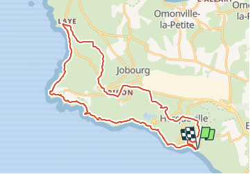
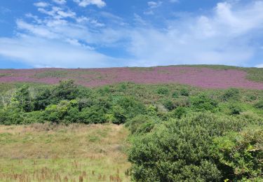
Randonnée Marche de 20 km à découvrir à Normandie, Manche, La Hague. Cette randonnée est proposée par PascalN.
Description
Départ depuis le stationnement en bas de la descente de Herquemoulin.
Suivez le GR223 jusque en haut d'Ecalgrain puis les sentiers locaux et véloroutes à travers les hameaux pour un retour par Herqueville.
Localisation
Pays :
France
Région :
Normandie
Département/Province :
Manche
Commune :
La Hague
Localité :
Herqueville
Départ:(Dec)
Départ:(UTM)
581390 ; 5501265 (30U) N.
Commentaires
Randonnées à proximité
![Randonnée V.T.T. La Hague - Le Tour des Echoués - Jobourg - Photo](https://media.geolcdn.com/t/375/260/ext.jpg?maxdim=2&url=https%3A%2F%2Fservices.sitytrail.com%2FGeolivesWS%2FDownloadMedia.ashx%3FTrailID%3D173186%26Media%3D14770_5.jpg)
![V.T.T. V.T.T.](https://static1.geolcdn.com/sitytour/trail-icons/202.png)
Le Tour des Echoués - Jobourg
V.T.T.
Moyen
(1)
La Hague,
Normandie,
Manche,
France
![](/images/other/stat-length.png)
26 km | 32 km-effort
2h 0min
![](https://static1.geolcdn.com/siteimages/upload/files/16400158638029165_repeat_loop_refresh_sync_direction_icon.png)
Oui
![Randonnée Marche La Hague - Ecalgrain et sa baie. - Photo](https://media.geolcdn.com/t/375/260/ext.jpg?maxdim=2&url=https%3A%2F%2Fservices.sitytrail.com%2FGeolivesWS%2FDownloadMedia.ashx%3FTrailID%3D102758%26Media%3D3900_6.jpg)
![Marche Marche](https://static1.geolcdn.com/sitytour/trail-icons/101.png)
Ecalgrain et sa baie.
Marche
Difficile
(4)
La Hague,
Normandie,
Manche,
France
![](/images/other/stat-length.png)
13,4 km | 18,3 km-effort
3h 15min
![](https://static1.geolcdn.com/siteimages/upload/files/16400158638029165_repeat_loop_refresh_sync_direction_icon.png)
Oui
![Randonnée A pied La Hague - Séjour Cotentin Etape 3 Nez de Jobourg - Biville - Photo](https://media.geolcdn.com/t/375/260/0edaec19-e94e-4149-8092-0ff358c3dd07.jpg&format=jpg&maxdim=2)
![A pied A pied](https://static1.geolcdn.com/sitytour/trail-icons/100.png)
Séjour Cotentin Etape 3 Nez de Jobourg - Biville
A pied
Difficile
La Hague,
Normandie,
Manche,
France
![](/images/other/stat-length.png)
23 km | 33 km-effort
7h 30min
![](https://static1.geolcdn.com/siteimages/upload/files/16400158638029165_repeat_loop_refresh_sync_direction_icon.png)
Non
![Randonnée Marche La Hague - Séjour Cotentin Etape 4 Biville - Les Pieux - Photo](https://media.geolcdn.com/t/375/260/20c319c1-9c7e-4f29-bee7-385fa39e6485.jpg&format=jpg&maxdim=2)
![Marche Marche](https://static1.geolcdn.com/sitytour/trail-icons/101.png)
Séjour Cotentin Etape 4 Biville - Les Pieux
Marche
Difficile
La Hague,
Normandie,
Manche,
France
![](/images/other/stat-length.png)
29 km | 35 km-effort
6h 55min
![](https://static1.geolcdn.com/siteimages/upload/files/16400158638029165_repeat_loop_refresh_sync_direction_icon.png)
Non
![Randonnée Marche La Hague - Séjour Cotentin Etape 3 Le nez de Jobourg et Biville a corriger - Photo](https://media.geolcdn.com/t/375/260/769074c5-2128-40cd-af27-847ab7c0e7c4.jpg&format=jpg&maxdim=2)
![Marche Marche](https://static1.geolcdn.com/sitytour/trail-icons/101.png)
Séjour Cotentin Etape 3 Le nez de Jobourg et Biville a corriger
Marche
Très difficile
La Hague,
Normandie,
Manche,
France
![](/images/other/stat-length.png)
23 km | 33 km-effort
7h 31min
![](https://static1.geolcdn.com/siteimages/upload/files/16400158638029165_repeat_loop_refresh_sync_direction_icon.png)
Non
![Randonnée A pied La Hague - Séjour Cotentin Etape 2 Boucle Jobourg La Hague - Port Racine - Omonville la petite - Photo](https://media.geolcdn.com/t/375/260/c0e0de9e-3bd4-4319-af5c-c6b5aff35ffd.jpg&format=jpg&maxdim=2)
![A pied A pied](https://static1.geolcdn.com/sitytour/trail-icons/100.png)
Séjour Cotentin Etape 2 Boucle Jobourg La Hague - Port Racine - Omonville la ...
A pied
Difficile
La Hague,
Normandie,
Manche,
France
![](/images/other/stat-length.png)
28 km | 34 km-effort
7h 44min
![](https://static1.geolcdn.com/siteimages/upload/files/16400158638029165_repeat_loop_refresh_sync_direction_icon.png)
Oui
![Randonnée Marche La Hague - Vauville - Photo](https://media.geolcdn.com/t/375/260/2b220e39-b1b1-4526-a0cf-9eab92539eb2.jpg&format=jpg&maxdim=2)
![Marche Marche](https://static1.geolcdn.com/sitytour/trail-icons/101.png)
![Randonnée Marche La Hague - Magiquement votre - Photo](https://media.geolcdn.com/t/375/260/c49fffc8-7c79-42cf-a4d6-b3c2cf7eec90.jpg&format=jpg&maxdim=2)
![Marche Marche](https://static1.geolcdn.com/sitytour/trail-icons/101.png)
Magiquement votre
Marche
Moyen
La Hague,
Normandie,
Manche,
France
![](/images/other/stat-length.png)
25 km | 33 km-effort
6h 12min
![](https://static1.geolcdn.com/siteimages/upload/files/16400158638029165_repeat_loop_refresh_sync_direction_icon.png)
Oui
![Randonnée Marche La Hague - Autour de la ferme du Tourp - Photo](https://media.geolcdn.com/t/375/260/daff8d4b-c9f0-4a43-af85-079207cb08e2.jpg&format=jpg&maxdim=2)
![Marche Marche](https://static1.geolcdn.com/sitytour/trail-icons/101.png)
Autour de la ferme du Tourp
Marche
Moyen
La Hague,
Normandie,
Manche,
France
![](/images/other/stat-length.png)
21 km | 27 km-effort
1h 46min
![](https://static1.geolcdn.com/siteimages/upload/files/16400158638029165_repeat_loop_refresh_sync_direction_icon.png)
Non