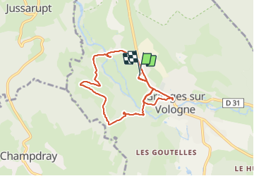
![](/images/other/stat-length.png)
![Randonnée Marche Granges-Aumontzey - Autour des Charmalynes - Photo](https://media.geolcdn.com/t/1900/400/ext.pjpeg?maxdim=2&url=https%3A%2F%2Fstatic1.geolcdn.com%2Fsiteimages%2Fupload%2Ffiles%2F1553511878bg_sport_marche.png)
Autour des Charmalynes
Didier-114
Utilisateur
![Longueur](/images/other/stat-length.png)
Longueur
7,6 km
![Altitude max](https://static1.geolcdn.com/siteimages/upload/files/1508320355ic_sort_altitude_max_24dp.png)
Altitude max
634 m
![Dénivelé positif](https://static1.geolcdn.com/siteimages/upload/files/1508320355ic_sort_den_pos_24dp.png)
Dénivelé positif
172 m
![Km-Effort](/images/other/stat-length.png)
Km-Effort
9,9 km
![Altitude min](https://static1.geolcdn.com/siteimages/upload/files/1508320355ic_sort_altitude_min_24dp.png)
Altitude min
477 m
![Dénivelé négatif](https://static1.geolcdn.com/siteimages/upload/files/1508320355ic_sort_den_neg_24dp.png)
Dénivelé négatif
171 m
![Boucle](https://static1.geolcdn.com/siteimages/upload/files/16400158638029165_repeat_loop_refresh_sync_direction_icon.png)
Boucle
Oui
Date de création :
2021-06-20 07:36:48.806
Dernière modification :
2021-06-20 09:58:29.523
![Marche](https://static1.geolcdn.com/sitytour/trail-icons/101.png)
2h20
Difficulté : Facile
![Scannez ce code QR pour ouvrir la randonnée dans l'application SityTrail](https://capi.geolives.com/qq0zvz2zws4bq2lad0pu/sitytour/trails/2833099/qr.png?size=200)
Application GPS de randonnée GRATUITE
À propos
Randonnée Marche de 7,6 km à découvrir à Grand Est, Vosges, Granges-Aumontzey. Cette randonnée est proposée par Didier-114.
Description
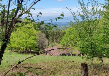
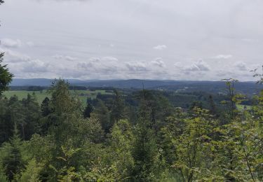
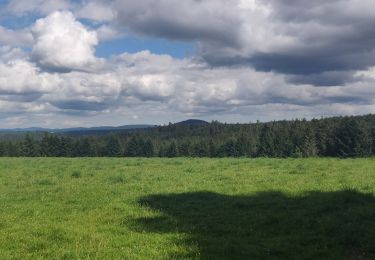
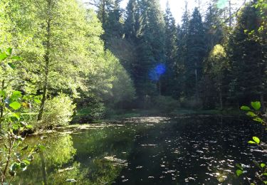
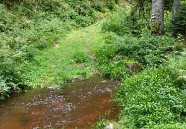
1er partie en sous bois, belle vue sur la vallée.
retour par le centre ville
Localisation
Pays :
France
Région :
Grand Est
Département/Province :
Vosges
Commune :
Granges-Aumontzey
Localité :
Granges-sur-Vologne
Départ:(Dec)
Départ:(UTM)
334931 ; 5335254 (32U) N.
Commentaires
Randonnées à proximité
![Randonnée Marche Rehaupal - Champdray - Photo](https://media.geolcdn.com/t/375/260/ext.jpg?maxdim=2&url=https%3A%2F%2Fservices.sitytrail.com%2FGeolivesWS%2FDownloadMedia.ashx%3FTrailID%3D955415%26Media%3Dfix__20180501125437.jpg)
![Marche Marche](https://static1.geolcdn.com/sitytour/trail-icons/101.png)
![Randonnée Marche Rehaupal - rehaupal 2 march ettes - Photo](https://media.geolcdn.com/t/375/260/ext.jpg?maxdim=2&url=https%3A%2F%2Fstatic1.geolcdn.com%2Fsiteimages%2Fupload%2Ffiles%2F1553511878bg_sport_marche.png)
![Marche Marche](https://static1.geolcdn.com/sitytour/trail-icons/101.png)
rehaupal 2 march ettes
Marche
Moyen
(1)
Rehaupal,
Grand Est,
Vosges,
France
![](/images/other/stat-length.png)
10,9 km | 15,7 km-effort
2h 29min
![](https://static1.geolcdn.com/siteimages/upload/files/16400158638029165_repeat_loop_refresh_sync_direction_icon.png)
Oui
![Randonnée Vélo électrique Champdray - champdray rehaupal - Photo](https://media.geolcdn.com/t/375/260/33a99359-8f75-4cfa-b7c3-e2bb27c63958.jpg&format=jpg&maxdim=2)
![Vélo électrique Vélo électrique](https://static1.geolcdn.com/sitytour/trail-icons/205.png)
champdray rehaupal
Vélo électrique
Facile
Champdray,
Grand Est,
Vosges,
France
![](/images/other/stat-length.png)
20 km | 28 km-effort
2h 22min
![](https://static1.geolcdn.com/siteimages/upload/files/16400158638029165_repeat_loop_refresh_sync_direction_icon.png)
Oui
![Randonnée Vélo électrique Granges-Aumontzey - chappes-arrentes-barbey seroux - Photo](https://media.geolcdn.com/t/375/260/91b76714-078c-4eb9-bbeb-e52c24579f7b.jpg&format=jpg&maxdim=2)
![Vélo électrique Vélo électrique](https://static1.geolcdn.com/sitytour/trail-icons/205.png)
chappes-arrentes-barbey seroux
Vélo électrique
Difficile
Granges-Aumontzey,
Grand Est,
Vosges,
France
![](/images/other/stat-length.png)
21 km | 28 km-effort
1h 45min
![](https://static1.geolcdn.com/siteimages/upload/files/16400158638029165_repeat_loop_refresh_sync_direction_icon.png)
Oui
![Randonnée Vélo électrique Granges-Aumontzey - granges-Spie mont-pierre sacrifice - Photo](https://media.geolcdn.com/t/375/260/8d5ac709-0a35-4246-a57f-6de4b02b711e.jpg&format=jpg&maxdim=2)
![Vélo électrique Vélo électrique](https://static1.geolcdn.com/sitytour/trail-icons/205.png)
granges-Spie mont-pierre sacrifice
Vélo électrique
Très difficile
Granges-Aumontzey,
Grand Est,
Vosges,
France
![](/images/other/stat-length.png)
19,1 km | 25 km-effort
1h 37min
![](https://static1.geolcdn.com/siteimages/upload/files/16400158638029165_repeat_loop_refresh_sync_direction_icon.png)
Oui
![Randonnée Vélo électrique Granges-Aumontzey - berchigranges-steniole - Photo](https://media.geolcdn.com/t/375/260/702886b0-7742-4e5b-a851-494a8794ea2e.jpg&format=jpg&maxdim=2)
![Vélo électrique Vélo électrique](https://static1.geolcdn.com/sitytour/trail-icons/205.png)
berchigranges-steniole
Vélo électrique
Très difficile
Granges-Aumontzey,
Grand Est,
Vosges,
France
![](/images/other/stat-length.png)
17,1 km | 23 km-effort
2h 3min
![](https://static1.geolcdn.com/siteimages/upload/files/16400158638029165_repeat_loop_refresh_sync_direction_icon.png)
Oui
![Randonnée Randonnée équestre La Chapelle-devant-Bruyères - Acpl la chapelle devant bruyères - Photo](https://media.geolcdn.com/t/375/260/ext.jpg?maxdim=2&url=https%3A%2F%2Fstatic1.geolcdn.com%2Fsiteimages%2Fupload%2Ffiles%2F1524743154cheval.jpg)
![Randonnée équestre Randonnée équestre](https://static1.geolcdn.com/sitytour/trail-icons/301.png)
Acpl la chapelle devant bruyères
Randonnée équestre
Très facile
La Chapelle-devant-Bruyères,
Grand Est,
Vosges,
France
![](/images/other/stat-length.png)
30 km | 40 km-effort
5h 32min
![](https://static1.geolcdn.com/siteimages/upload/files/16400158638029165_repeat_loop_refresh_sync_direction_icon.png)
Oui
![Randonnée équestre Randonnée équestre](https://static1.geolcdn.com/sitytour/trail-icons/301.png)
2018-10-14 Rando CVA Vosges Granges sur Vologne Taintrux
Randonnée équestre
Facile
Granges-Aumontzey,
Grand Est,
Vosges,
France
![](/images/other/stat-length.png)
23 km | 31 km-effort
3h 45min
![](https://static1.geolcdn.com/siteimages/upload/files/16400158638029165_repeat_loop_refresh_sync_direction_icon.png)
Non
![Randonnée Marche Rehaupal - 2016 08 05 régional trou de l'enfer - Photo](https://media.geolcdn.com/t/375/260/ext.jpg?maxdim=2&url=https%3A%2F%2Fservices.sitytrail.com%2FGeolivesWS%2FDownloadMedia.ashx%3FTrailID%3D609127%26Media%3Dfix__20160805145905.jpg)
![Marche Marche](https://static1.geolcdn.com/sitytour/trail-icons/101.png)
2016 08 05 régional trou de l'enfer
Marche
Facile
Rehaupal,
Grand Est,
Vosges,
France
![](/images/other/stat-length.png)
9 km | 12,2 km-effort
2h 27min
![](https://static1.geolcdn.com/siteimages/upload/files/16400158638029165_repeat_loop_refresh_sync_direction_icon.png)
Oui