![](/images/other/stat-length.png)
![Randonnée Marche Saint-Antonin-Noble-Val - Servanac, grotte du Trassadou, juin 2021 - Photo](https://media.geolcdn.com/t/1900/400/ext.pjpeg?maxdim=2&url=https%3A%2F%2Fstatic1.geolcdn.com%2Fsiteimages%2Fupload%2Ffiles%2F1553511878bg_sport_marche.png)
Servanac, grotte du Trassadou, juin 2021
BernardEsteban
Utilisateur
![Longueur](/images/other/stat-length.png)
Longueur
13,4 km
![Altitude max](https://static1.geolcdn.com/siteimages/upload/files/1508320355ic_sort_altitude_max_24dp.png)
Altitude max
341 m
![Dénivelé positif](https://static1.geolcdn.com/siteimages/upload/files/1508320355ic_sort_den_pos_24dp.png)
Dénivelé positif
197 m
![Km-Effort](/images/other/stat-length.png)
Km-Effort
16 km
![Altitude min](https://static1.geolcdn.com/siteimages/upload/files/1508320355ic_sort_altitude_min_24dp.png)
Altitude min
265 m
![Dénivelé négatif](https://static1.geolcdn.com/siteimages/upload/files/1508320355ic_sort_den_neg_24dp.png)
Dénivelé négatif
196 m
![Boucle](https://static1.geolcdn.com/siteimages/upload/files/16400158638029165_repeat_loop_refresh_sync_direction_icon.png)
Boucle
Oui
Date de création :
2021-06-17 08:02:06.61
Dernière modification :
2021-06-17 16:42:16.934
![Marche](https://static1.geolcdn.com/sitytour/trail-icons/101.png)
5h41
Difficulté : Très facile
![Scannez ce code QR pour ouvrir la randonnée dans l'application SityTrail](https://capi.geolives.com/qq0zvz2zws4bq2lad0pu/sitytour/trails/2830022/qr.png?size=200)
Application GPS de randonnée GRATUITE
À propos
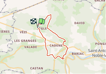
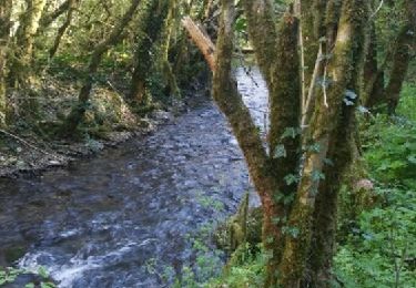
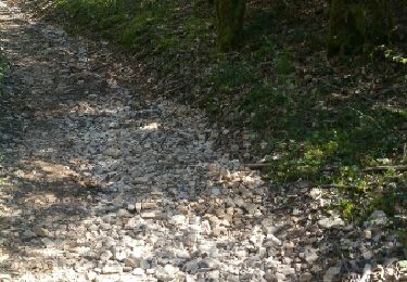
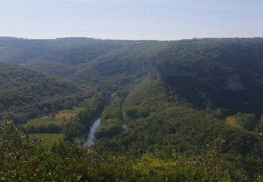
Randonnée Marche de 13,4 km à découvrir à Occitanie, Tarn-et-Garonne, Saint-Antonin-Noble-Val. Cette randonnée est proposée par BernardEsteban.
Description
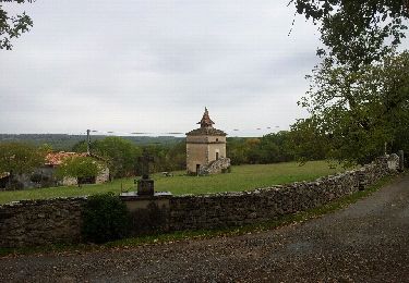
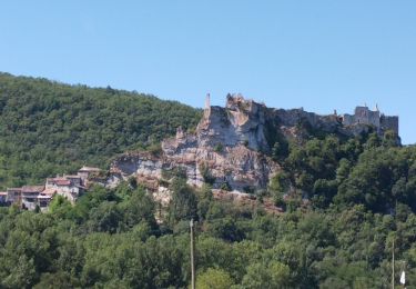
Belle rando facile à faire par temps pas trop chaud, avec un petit aller/retour dans la grotte pour un magnifique point de vue sur les gorges.
Localisation
Pays :
France
Région :
Occitanie
Département/Province :
Tarn-et-Garonne
Commune :
Saint-Antonin-Noble-Val
Localité :
Unknown
Départ:(Dec)
Départ:(UTM)
394651 ; 4891991 (31T) N.
Commentaires
Randonnées à proximité
![Randonnée Marche Lavaurette - Lavaurette - Photo](https://media.geolcdn.com/t/375/260/ext.jpg?maxdim=2&url=https%3A%2F%2Fservices.sitytrail.com%2FGeolivesWS%2FDownloadMedia.ashx%3FTrailID%3D158113%26Media%3D20121014133654.jpeg)
![Marche Marche](https://static1.geolcdn.com/sitytour/trail-icons/101.png)
Lavaurette
Marche
Très facile
Lavaurette,
Occitanie,
Tarn-et-Garonne,
France
![](/images/other/stat-length.png)
8,6 km | 10 km-effort
2h 39min
![](https://static1.geolcdn.com/siteimages/upload/files/16400158638029165_repeat_loop_refresh_sync_direction_icon.png)
Oui
![Randonnée V.T.T. Saint-Antonin-Noble-Val - st Antonin Noble Val à Penne forteresse - Photo](https://media.geolcdn.com/t/375/260/7b305fc3-b5d8-4160-a1cd-df20080e3bef.jpg&format=jpg&maxdim=2)
![V.T.T. V.T.T.](https://static1.geolcdn.com/sitytour/trail-icons/202.png)
st Antonin Noble Val à Penne forteresse
V.T.T.
Facile
Saint-Antonin-Noble-Val,
Occitanie,
Tarn-et-Garonne,
France
![](/images/other/stat-length.png)
11,8 km | 15,9 km-effort
1h 31min
![](https://static1.geolcdn.com/siteimages/upload/files/16400158638029165_repeat_loop_refresh_sync_direction_icon.png)
Non
![Randonnée Marche Saint-Antonin-Noble-Val - Saint Antonin - Photo](https://media.geolcdn.com/t/375/260/866e6fde-0829-4f6f-9aa5-855ea15fe06f.jpg&format=jpg&maxdim=2)
![Marche Marche](https://static1.geolcdn.com/sitytour/trail-icons/101.png)
Saint Antonin
Marche
Très facile
Saint-Antonin-Noble-Val,
Occitanie,
Tarn-et-Garonne,
France
![](/images/other/stat-length.png)
7 km | 9,3 km-effort
3h 57min
![](https://static1.geolcdn.com/siteimages/upload/files/16400158638029165_repeat_loop_refresh_sync_direction_icon.png)
Oui
![Randonnée Marche Saint-Antonin-Noble-Val - pr8 saint Antonin au tour de la Gourgue - Photo](https://media.geolcdn.com/t/375/260/ext.jpg?maxdim=2&url=https%3A%2F%2Fservices.sitytrail.com%2FGeolivesWS%2FDownloadMedia.ashx%3FTrailID%3D804530%26Media%3D4a1478b4-1f68-42d1-b682-89d5e53dc28d.jpg)
![Marche Marche](https://static1.geolcdn.com/sitytour/trail-icons/101.png)
pr8 saint Antonin au tour de la Gourgue
Marche
Moyen
Saint-Antonin-Noble-Val,
Occitanie,
Tarn-et-Garonne,
France
![](/images/other/stat-length.png)
7 km | 9,3 km-effort
1h 36min
![](https://static1.geolcdn.com/siteimages/upload/files/16400158638029165_repeat_loop_refresh_sync_direction_icon.png)
Oui
![Randonnée Marche Saint-Antonin-Noble-Val - pr8 saint Antonin au tour de la Gourgue - Photo](https://media.geolcdn.com/t/375/260/ext.jpg?maxdim=2&url=https%3A%2F%2Fservices.sitytrail.com%2FGeolivesWS%2FDownloadMedia.ashx%3FTrailID%3D728922%26Media%3Dfix__20170408154851.jpg)
![Marche Marche](https://static1.geolcdn.com/sitytour/trail-icons/101.png)
pr8 saint Antonin au tour de la Gourgue
Marche
Moyen
Saint-Antonin-Noble-Val,
Occitanie,
Tarn-et-Garonne,
France
![](/images/other/stat-length.png)
7 km | 9,3 km-effort
1h 36min
![](https://static1.geolcdn.com/siteimages/upload/files/16400158638029165_repeat_loop_refresh_sync_direction_icon.png)
Oui
![Randonnée V.T.T. Saint-Antonin-Noble-Val - baradoy - Photo](https://media.geolcdn.com/t/375/260/ext.jpg?maxdim=2&url=https%3A%2F%2Fstatic1.geolcdn.com%2Fsiteimages%2Fupload%2Ffiles%2F1524743154velo.jpg)
![V.T.T. V.T.T.](https://static1.geolcdn.com/sitytour/trail-icons/202.png)
baradoy
V.T.T.
Moyen
Saint-Antonin-Noble-Val,
Occitanie,
Tarn-et-Garonne,
France
![](/images/other/stat-length.png)
23 km | 27 km-effort
1h 57min
![](https://static1.geolcdn.com/siteimages/upload/files/16400158638029165_repeat_loop_refresh_sync_direction_icon.png)
Non
![Randonnée Marche Montricoux - forêt de Brétou - Photo](https://media.geolcdn.com/t/375/260/ext.jpg?maxdim=2&url=https%3A%2F%2Fstatic1.geolcdn.com%2Fsiteimages%2Fupload%2Ffiles%2F1553511878bg_sport_marche.png)
![Marche Marche](https://static1.geolcdn.com/sitytour/trail-icons/101.png)
forêt de Brétou
Marche
Facile
Montricoux,
Occitanie,
Tarn-et-Garonne,
France
![](/images/other/stat-length.png)
8 km | 9,4 km-effort
2h 8min
![](https://static1.geolcdn.com/siteimages/upload/files/16400158638029165_repeat_loop_refresh_sync_direction_icon.png)
Oui
![Randonnée Marche Saint-Antonin-Noble-Val - randonnée au dessus de St Antonin - Photo](https://media.geolcdn.com/t/375/260/ext.jpg?maxdim=2&url=https%3A%2F%2Fservices.sitytrail.com%2FGeolivesWS%2FDownloadMedia.ashx%3FTrailID%3D739151%26Media%3Dfix__20170424100805.jpg)
![Marche Marche](https://static1.geolcdn.com/sitytour/trail-icons/101.png)
randonnée au dessus de St Antonin
Marche
Très facile
Saint-Antonin-Noble-Val,
Occitanie,
Tarn-et-Garonne,
France
![](/images/other/stat-length.png)
6,3 km | 7,3 km-effort
1h 40min
![](https://static1.geolcdn.com/siteimages/upload/files/16400158638029165_repeat_loop_refresh_sync_direction_icon.png)
Oui
![Randonnée Marche Saint-Antonin-Noble-Val - Brousses - Petit Jean - Photo](https://media.geolcdn.com/t/375/260/ext.jpg?maxdim=2&url=https%3A%2F%2Fstatic1.geolcdn.com%2Fsiteimages%2Fupload%2Ffiles%2F1553511878bg_sport_marche.png)
![Marche Marche](https://static1.geolcdn.com/sitytour/trail-icons/101.png)
Brousses - Petit Jean
Marche
Facile
Saint-Antonin-Noble-Val,
Occitanie,
Tarn-et-Garonne,
France
![](/images/other/stat-length.png)
8 km | 11,5 km-effort
2h 28min
![](https://static1.geolcdn.com/siteimages/upload/files/16400158638029165_repeat_loop_refresh_sync_direction_icon.png)
Oui
Super rando mais entrée grotte propriété privée sauvegarde gîte chauve-souris