![](/images/other/stat-length.png)
![Randonnée Marche Samoëns - en direction du Lac des Chambres - Photo](https://media.geolcdn.com/t/1900/400/c204689a-94b9-4718-b2f2-b2d7b5f4df02.jpg&format=pjpeg&maxdim=2)
en direction du Lac des Chambres
GuyVachet
Utilisateur
![Longueur](/images/other/stat-length.png)
![Altitude max](https://static1.geolcdn.com/siteimages/upload/files/1508320355ic_sort_altitude_max_24dp.png)
![Dénivelé positif](https://static1.geolcdn.com/siteimages/upload/files/1508320355ic_sort_den_pos_24dp.png)
![Km-Effort](/images/other/stat-length.png)
![Altitude min](https://static1.geolcdn.com/siteimages/upload/files/1508320355ic_sort_altitude_min_24dp.png)
![Dénivelé négatif](https://static1.geolcdn.com/siteimages/upload/files/1508320355ic_sort_den_neg_24dp.png)
![Boucle](https://static1.geolcdn.com/siteimages/upload/files/16400158638029165_repeat_loop_refresh_sync_direction_icon.png)
![Marche](https://static1.geolcdn.com/sitytour/trail-icons/101.png)
6h20
Difficulté : Difficile
![Scannez ce code QR pour ouvrir la randonnée dans l'application SityTrail](https://capi.geolives.com/qq0zvz2zws4bq2lad0pu/sitytour/trails/2828235/qr.png?size=200)
Application GPS de randonnée GRATUITE
À propos
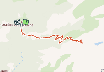
Randonnée Marche de 11 km à découvrir à Auvergne-Rhône-Alpes, Haute-Savoie, Samoëns. Cette randonnée est proposée par GuyVachet.
Description
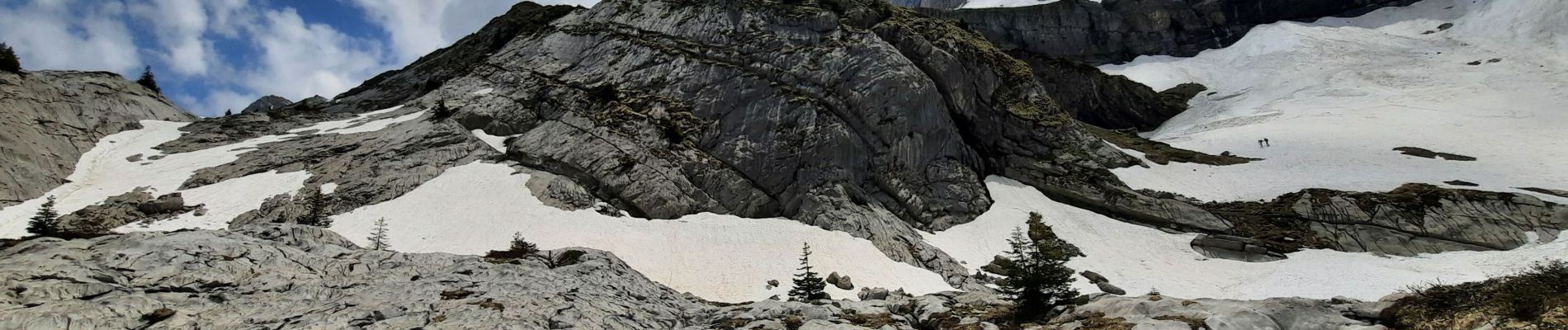
Aller/Retour en direction du Lac des Chambres en passant par le Refuge de Folly. La première partie commence par la Dalle du Tuet avec des passages aériens même s'ils sont équipés par un câble. La passerelle permet de franchir la Lanche avant la montée en forêt au Refuge de Folly. Après le refuge, la vue s'ouvre notamment sur les Dents d'Oddaz. Cet itinéraire a été interrompu au niveau de la Stèle près du Gouffre Jean Bernard à cause de l'enneigement. Retour par le même chemin.
Localisation
Commentaires
Randonnées à proximité
![Randonnée Marche Samoëns - Samoens . gorges des tines - retour - Photo](https://media.geolcdn.com/t/375/260/9ca94656-f570-41a8-90f6-cc5f5e98fa82.jpg&format=jpg&maxdim=2)
![Marche Marche](https://static1.geolcdn.com/sitytour/trail-icons/101.png)
Marche
![](/images/other/stat-length.png)
![](https://static1.geolcdn.com/siteimages/upload/files/16400158638029165_repeat_loop_refresh_sync_direction_icon.png)
![Randonnée Marche Samoëns - La Tête de Bostan - Photo](https://media.geolcdn.com/t/375/260/ext.jpg?maxdim=2&url=https%3A%2F%2Fstatic1.geolcdn.com%2Fsiteimages%2Fupload%2Ffiles%2F1553511878bg_sport_marche.png)
![Marche Marche](https://static1.geolcdn.com/sitytour/trail-icons/101.png)
Marche
![](/images/other/stat-length.png)
![](https://static1.geolcdn.com/siteimages/upload/files/16400158638029165_repeat_loop_refresh_sync_direction_icon.png)
![Randonnée Ski de randonnée Samoëns - 2025-01-30 Sortie Ski de Rando Col de la Golese - Photo](https://media.geolcdn.com/t/375/260/5172d417-9875-43d9-89bb-031c8ee85781.jpg&format=jpg&maxdim=2)
![Ski de randonnée Ski de randonnée](https://static1.geolcdn.com/sitytour/trail-icons/503.png)
Ski de randonnée
![](/images/other/stat-length.png)
![](https://static1.geolcdn.com/siteimages/upload/files/16400158638029165_repeat_loop_refresh_sync_direction_icon.png)
![Randonnée Marche Verchaix - col de joux plane - Photo](https://media.geolcdn.com/t/375/260/f5f22de2-b8d8-4ec7-857b-352656491634.jpg&format=jpg&maxdim=2)
![Marche Marche](https://static1.geolcdn.com/sitytour/trail-icons/101.png)
Marche
![](/images/other/stat-length.png)
![](https://static1.geolcdn.com/siteimages/upload/files/16400158638029165_repeat_loop_refresh_sync_direction_icon.png)
![Randonnée Marche Samoëns - La tête de Bostan - Photo](https://media.geolcdn.com/t/375/260/c42830f7-a262-4abd-8f00-d269896222b2.jpg&format=jpg&maxdim=2)
![Marche Marche](https://static1.geolcdn.com/sitytour/trail-icons/101.png)
Marche
![](/images/other/stat-length.png)
![](https://static1.geolcdn.com/siteimages/upload/files/16400158638029165_repeat_loop_refresh_sync_direction_icon.png)
![Randonnée Marche Samoëns - SAMOENS: LES ALLAMANDS - BOSTAN (CHALETS - REFUGE - COL - TETE) - GOLESE - Photo](https://media.geolcdn.com/t/375/260/c5ba1cee-0408-4163-a2ab-ac65d7121802.jpg&format=jpg&maxdim=2)
![Marche Marche](https://static1.geolcdn.com/sitytour/trail-icons/101.png)
Marche
![](/images/other/stat-length.png)
![](https://static1.geolcdn.com/siteimages/upload/files/16400158638029165_repeat_loop_refresh_sync_direction_icon.png)
![Randonnée Marche Samoëns - les chalets du Bémont et cascade du Nant d Ant - Photo](https://media.geolcdn.com/t/375/260/70ac3ce4-77a9-4b40-b9e3-5a1ff6333052.jpg&format=jpg&maxdim=2)
![Marche Marche](https://static1.geolcdn.com/sitytour/trail-icons/101.png)
Marche
![](/images/other/stat-length.png)
![](https://static1.geolcdn.com/siteimages/upload/files/16400158638029165_repeat_loop_refresh_sync_direction_icon.png)
![Randonnée Marche Samoëns - SAMOENS: LAC DES CHAMBRES - Photo](https://media.geolcdn.com/t/375/260/cd8f3e5f-51d1-4c9a-9456-e0bd19938b89.jpg&format=jpg&maxdim=2)
![Marche Marche](https://static1.geolcdn.com/sitytour/trail-icons/101.png)
Marche
![](/images/other/stat-length.png)
![](https://static1.geolcdn.com/siteimages/upload/files/16400158638029165_repeat_loop_refresh_sync_direction_icon.png)
![Randonnée Marche Samoëns - SAMOENS: BOSTAN - GOLESE - Photo](https://media.geolcdn.com/t/375/260/6d485ceb-76c9-494d-ab79-683ad7388c0a.jpg&format=jpg&maxdim=2)
![Marche Marche](https://static1.geolcdn.com/sitytour/trail-icons/101.png)
Marche
![](/images/other/stat-length.png)
![](https://static1.geolcdn.com/siteimages/upload/files/16400158638029165_repeat_loop_refresh_sync_direction_icon.png)