![](/images/other/stat-length.png)
Via ferrata Plan de Bouc
djrem971
Utilisateur
![Longueur](/images/other/stat-length.png)
![Altitude max](https://static1.geolcdn.com/siteimages/upload/files/1508320355ic_sort_altitude_max_24dp.png)
![Dénivelé positif](https://static1.geolcdn.com/siteimages/upload/files/1508320355ic_sort_den_pos_24dp.png)
![Km-Effort](/images/other/stat-length.png)
![Altitude min](https://static1.geolcdn.com/siteimages/upload/files/1508320355ic_sort_altitude_min_24dp.png)
![Dénivelé négatif](https://static1.geolcdn.com/siteimages/upload/files/1508320355ic_sort_den_neg_24dp.png)
![Boucle](https://static1.geolcdn.com/siteimages/upload/files/16400158638029165_repeat_loop_refresh_sync_direction_icon.png)
![Via ferrata](https://static1.geolcdn.com/sitytour/trail-icons/902.png)
2h57
Difficulté : Très facile
![Scannez ce code QR pour ouvrir la randonnée dans l'application SityTrail](https://capi.geolives.com/qq0zvz2zws4bq2lad0pu/sitytour/trails/2827677/qr.png?size=200)
Application GPS de randonnée GRATUITE
À propos
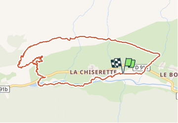
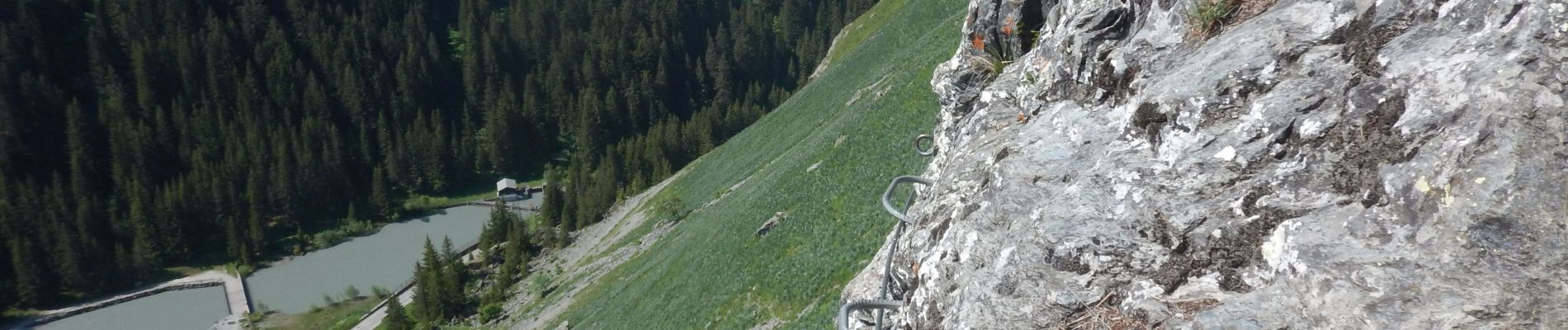
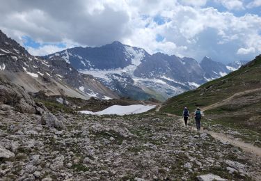
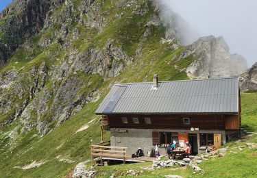
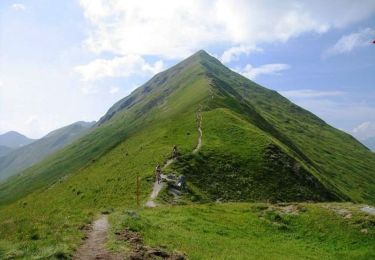
Randonnée Via ferrata de 6,4 km à découvrir à Auvergne-Rhône-Alpes, Savoie, Champagny-en-Vanoise. Cette randonnée est proposée par djrem971.
Description
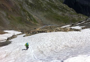
Cette via ferrata ne présente strictement aucune difficulté, seules les marches d'approche et de retour peuvent paraître assez longues.
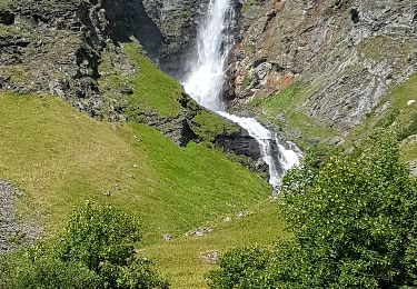
Très belle vue, le passage de l'unique échelle du parcours est une bonne initiation à ce type d'accessoire dans les via.
Localisation
Commentaires
Randonnées à proximité
![Randonnée Marche Champagny-en-Vanoise - col du plan Séry et du palet - Photo](https://media.geolcdn.com/t/375/260/69b57f21-ba87-483d-8fa5-10752fbbf208.jpg&format=jpg&maxdim=2)
![Marche Marche](https://static1.geolcdn.com/sitytour/trail-icons/101.png)
Marche
![](/images/other/stat-length.png)
![](https://static1.geolcdn.com/siteimages/upload/files/16400158638029165_repeat_loop_refresh_sync_direction_icon.png)
![Randonnée Marche Planay - le refuge du Grand Bec (boucle) - Photo](https://media.geolcdn.com/t/375/260/922fab93-817c-41fb-abcc-50a27af96e54.jpg&format=jpg&maxdim=2)
![Marche Marche](https://static1.geolcdn.com/sitytour/trail-icons/101.png)
Marche
![](/images/other/stat-length.png)
![](https://static1.geolcdn.com/siteimages/upload/files/16400158638029165_repeat_loop_refresh_sync_direction_icon.png)
![Randonnée Marche Champagny-en-Vanoise - Sentier des glaciers-Parc de la Vanoise 18 07 2020 - Photo](https://media.geolcdn.com/t/375/260/6c753556-2927-4df0-8c6a-93e196eff404.jpg&format=jpg&maxdim=2)
![Marche Marche](https://static1.geolcdn.com/sitytour/trail-icons/101.png)
Marche
![](/images/other/stat-length.png)
![](https://static1.geolcdn.com/siteimages/upload/files/16400158638029165_repeat_loop_refresh_sync_direction_icon.png)
![Randonnée Marche Planay - Le refuge du Grand Bec - Photo](https://media.geolcdn.com/t/375/260/62079f41-6456-403e-9adb-431c7cf6ef91.jpg&format=jpg&maxdim=2)
![Marche Marche](https://static1.geolcdn.com/sitytour/trail-icons/101.png)
Marche
![](/images/other/stat-length.png)
![](https://static1.geolcdn.com/siteimages/upload/files/16400158638029165_repeat_loop_refresh_sync_direction_icon.png)
![Randonnée Marche Champagny-en-Vanoise - La Glières - Photo](https://media.geolcdn.com/t/375/260/19849bd1-ad2f-4bb3-b2cf-15a17bec9903.jpg&format=jpg&maxdim=2)
![Marche Marche](https://static1.geolcdn.com/sitytour/trail-icons/101.png)
Marche
![](/images/other/stat-length.png)
![](https://static1.geolcdn.com/siteimages/upload/files/16400158638029165_repeat_loop_refresh_sync_direction_icon.png)
![Randonnée Marche Champagny-en-Vanoise - Le lac de la gliere - Photo](https://media.geolcdn.com/t/375/260/c8ad1819-128d-42fc-9005-e8b6e56b8154.jpg&format=jpg&maxdim=2)
![Marche Marche](https://static1.geolcdn.com/sitytour/trail-icons/101.png)
Marche
![](/images/other/stat-length.png)
![](https://static1.geolcdn.com/siteimages/upload/files/16400158638029165_repeat_loop_refresh_sync_direction_icon.png)
![Randonnée Marche Champagny-en-Vanoise - CHAMPAGNY-EN-VANOISE (73) - Photo](https://media.geolcdn.com/t/375/260/ext.jpg?maxdim=2&url=https%3A%2F%2Fservices.sitytrail.com%2FGeolivesWS%2FDownloadMedia.ashx%3FTrailID%3D1007079%26Media%3Dfix__20180719171504.jpg)
![Marche Marche](https://static1.geolcdn.com/sitytour/trail-icons/101.png)
Marche
![](/images/other/stat-length.png)
![](https://static1.geolcdn.com/siteimages/upload/files/16400158638029165_repeat_loop_refresh_sync_direction_icon.png)
![Randonnée Marche Champagny-en-Vanoise - Le col de Charde (MTH-P) - Photo](https://media.geolcdn.com/t/375/260/ext.jpg?maxdim=2&url=https%3A%2F%2Fservices.sitytrail.com%2FGeolivesWS%2FDownloadMedia.ashx%3FTrailID%3D331992%26Media%3D20140807131136.jpg)
![Marche Marche](https://static1.geolcdn.com/sitytour/trail-icons/101.png)
Marche
![](/images/other/stat-length.png)
![](https://static1.geolcdn.com/siteimages/upload/files/16400158638029165_repeat_loop_refresh_sync_direction_icon.png)
![Randonnée V.T.T. La Plagne-Tarentaise - Crête des Etroits, Bécoin, Verdons et la Gde Rochette - Photo](https://media.geolcdn.com/t/375/260/ext.jpg?maxdim=2&url=https%3A%2F%2Fservices.sitytrail.com%2FGeolivesWS%2FDownloadMedia.ashx%3FTrailID%3D101086%26Media%3D575_3.jpg)
![V.T.T. V.T.T.](https://static1.geolcdn.com/sitytour/trail-icons/202.png)
V.T.T.
![](/images/other/stat-length.png)
![](https://static1.geolcdn.com/siteimages/upload/files/16400158638029165_repeat_loop_refresh_sync_direction_icon.png)