![](/images/other/stat-length.png)
![Randonnée V.T.T. Charleville-Mézières - 20210613 VTTAE Charleville Givet 6 muscu 10 AE - Photo](https://media.geolcdn.com/t/1900/400/ext.pjpeg?maxdim=2&url=https%3A%2F%2Fstatic1.geolcdn.com%2Fsiteimages%2Fupload%2Ffiles%2F1524743154velo.jpg)
20210613 VTTAE Charleville Givet 6 muscu 10 AE
GeGe08
Utilisateur
![Longueur](/images/other/stat-length.png)
Longueur
75 km
![Altitude max](https://static1.geolcdn.com/siteimages/upload/files/1508320355ic_sort_altitude_max_24dp.png)
Altitude max
501 m
![Dénivelé positif](https://static1.geolcdn.com/siteimages/upload/files/1508320355ic_sort_den_pos_24dp.png)
Dénivelé positif
1807 m
![Km-Effort](/images/other/stat-length.png)
Km-Effort
99 km
![Altitude min](https://static1.geolcdn.com/siteimages/upload/files/1508320355ic_sort_altitude_min_24dp.png)
Altitude min
91 m
![Dénivelé négatif](https://static1.geolcdn.com/siteimages/upload/files/1508320355ic_sort_den_neg_24dp.png)
Dénivelé négatif
1857 m
![Boucle](https://static1.geolcdn.com/siteimages/upload/files/16400158638029165_repeat_loop_refresh_sync_direction_icon.png)
Boucle
Non
Date de création :
2021-06-14 15:36:47.5
Dernière modification :
2021-06-16 11:22:59.224
![V.T.T.](https://static1.geolcdn.com/sitytour/trail-icons/202.png)
--
Difficulté : Inconnu
![Scannez ce code QR pour ouvrir la randonnée dans l'application SityTrail](https://capi.geolives.com/qq0zvz2zws4bq2lad0pu/sitytour/trails/2826950/qr.png?size=200)
Application GPS de randonnée GRATUITE
À propos
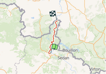
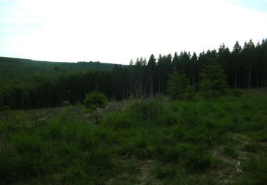
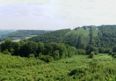
Randonnée V.T.T. de 75 km à découvrir à Grand Est, Ardennes, Charleville-Mézières. Cette randonnée est proposée par GeGe08.
Description
10 en VTTAE et 6 en VTT musculaires.
De belles montées et de belles descentes, de beaux points de vue.
belle performance et belle journée.
retour en train possible
Localisation
Pays :
France
Région :
Grand Est
Département/Province :
Ardennes
Commune :
Charleville-Mézières
Localité :
Unknown
Départ:(Dec)
Départ:(UTM)
623005 ; 5512647 (31U) N.
Commentaires
Randonnées à proximité
![Randonnée Marche Chalandry-Elaire - Chalandry cimetière 2023 (Jeudi) - Photo](https://media.geolcdn.com/t/375/260/ext.jpg?maxdim=2&url=https%3A%2F%2Fstatic1.geolcdn.com%2Fsiteimages%2Fupload%2Ffiles%2F1553511878bg_sport_marche.png)
![Marche Marche](https://static1.geolcdn.com/sitytour/trail-icons/101.png)
Chalandry cimetière 2023 (Jeudi)
Marche
Difficile
(1)
Chalandry-Elaire,
Grand Est,
Ardennes,
France
![](/images/other/stat-length.png)
11 km | 13,7 km-effort
3h 6min
![](https://static1.geolcdn.com/siteimages/upload/files/16400158638029165_repeat_loop_refresh_sync_direction_icon.png)
Oui
![Randonnée Marche Charleville-Mézières - De Charleville Mézières à Olly (Commune d'Illy) - Photo](https://media.geolcdn.com/t/375/260/7d73bd6e-f0b7-4726-8c94-18c6cbf615f3.jpg&format=jpg&maxdim=2)
![Marche Marche](https://static1.geolcdn.com/sitytour/trail-icons/101.png)
De Charleville Mézières à Olly (Commune d'Illy)
Marche
Moyen
Charleville-Mézières,
Grand Est,
Ardennes,
France
![](/images/other/stat-length.png)
28 km | 33 km-effort
8h 20min
![](https://static1.geolcdn.com/siteimages/upload/files/16400158638029165_repeat_loop_refresh_sync_direction_icon.png)
Non
![Randonnée Marche Charleville-Mézières - Berthaucourt - Photo](https://media.geolcdn.com/t/375/260/ext.jpg?maxdim=2&url=https%3A%2F%2Fservices.sitytrail.com%2FGeolivesWS%2FDownloadMedia.ashx%3FTrailID%3D1129015%26Media%3Dfix__20190331110619.jpg)
![Marche Marche](https://static1.geolcdn.com/sitytour/trail-icons/101.png)
Berthaucourt
Marche
Très facile
Charleville-Mézières,
Grand Est,
Ardennes,
France
![](/images/other/stat-length.png)
5,7 km | 7,1 km-effort
1h 34min
![](https://static1.geolcdn.com/siteimages/upload/files/16400158638029165_repeat_loop_refresh_sync_direction_icon.png)
Oui
![Randonnée V.T.T. Montcy-Notre-Dame - De Montcy Notre Dame vers Nouzonville - Photo](https://media.geolcdn.com/t/375/260/ext.jpg?maxdim=2&url=https%3A%2F%2Fservices.sitytrail.com%2FGeolivesWS%2FDownloadMedia.ashx%3FTrailID%3D191388%26Media%3D14958_3.jpg)
![V.T.T. V.T.T.](https://static1.geolcdn.com/sitytour/trail-icons/202.png)
De Montcy Notre Dame vers Nouzonville
V.T.T.
Difficile
Montcy-Notre-Dame,
Grand Est,
Ardennes,
France
![](/images/other/stat-length.png)
18,5 km | 24 km-effort
2h 15min
![](https://static1.geolcdn.com/siteimages/upload/files/16400158638029165_repeat_loop_refresh_sync_direction_icon.png)
Oui
![Randonnée Marche Aiglemont - aiglemont neufmanil - Photo](https://media.geolcdn.com/t/375/260/c41dda85-7d91-43e7-9172-d16cb3f7dd97.jpg&format=jpg&maxdim=2)
![Marche Marche](https://static1.geolcdn.com/sitytour/trail-icons/101.png)
aiglemont neufmanil
Marche
Moyen
Aiglemont,
Grand Est,
Ardennes,
France
![](/images/other/stat-length.png)
9,6 km | 13 km-effort
2h 52min
![](https://static1.geolcdn.com/siteimages/upload/files/16400158638029165_repeat_loop_refresh_sync_direction_icon.png)
Non
![Randonnée Marche Charleville-Mézières - charleville - Photo](https://media.geolcdn.com/t/375/260/b425e964-da00-4a73-ab81-faa929732266.jpg&format=jpg&maxdim=2)
![Marche Marche](https://static1.geolcdn.com/sitytour/trail-icons/101.png)
charleville
Marche
Facile
Charleville-Mézières,
Grand Est,
Ardennes,
France
![](/images/other/stat-length.png)
3,7 km | 4,5 km-effort
1h 30min
![](https://static1.geolcdn.com/siteimages/upload/files/16400158638029165_repeat_loop_refresh_sync_direction_icon.png)
Oui
![Randonnée V.T.T. Charleville-Mézières - 20200825 La Londe - Photo](https://media.geolcdn.com/t/375/260/84eeb30d-e64f-44c9-8274-3650356833df.jpg&format=jpg&maxdim=2)
![V.T.T. V.T.T.](https://static1.geolcdn.com/sitytour/trail-icons/202.png)
20200825 La Londe
V.T.T.
Très facile
Charleville-Mézières,
Grand Est,
Ardennes,
France
![](/images/other/stat-length.png)
778 km | 1272 km-effort
3h 36min
![](https://static1.geolcdn.com/siteimages/upload/files/16400158638029165_repeat_loop_refresh_sync_direction_icon.png)
Non
![Randonnée V.T.T. Charleville-Mézières - De La Havetière à Meillier Fontaine - Charleville Mézières - Photo](https://media.geolcdn.com/t/375/260/ext.jpg?maxdim=2&url=https%3A%2F%2Fservices.sitytrail.com%2FGeolivesWS%2FDownloadMedia.ashx%3FTrailID%3D172657%26Media%3D14028_1.jpg)
![V.T.T. V.T.T.](https://static1.geolcdn.com/sitytour/trail-icons/202.png)
De La Havetière à Meillier Fontaine - Charleville Mézières
V.T.T.
Difficile
Charleville-Mézières,
Grand Est,
Ardennes,
France
![](/images/other/stat-length.png)
20 km | 28 km-effort
2h 45min
![](https://static1.geolcdn.com/siteimages/upload/files/16400158638029165_repeat_loop_refresh_sync_direction_icon.png)
Non
![Randonnée V.T.T. La Francheville - Bois de la Havetière - Charleville Mézières - Photo](https://media.geolcdn.com/t/375/260/ext.jpg?maxdim=2&url=https%3A%2F%2Fservices.sitytrail.com%2FGeolivesWS%2FDownloadMedia.ashx%3FTrailID%3D129655%26Media%3D13183_1.jpg)
![V.T.T. V.T.T.](https://static1.geolcdn.com/sitytour/trail-icons/202.png)
Bois de la Havetière - Charleville Mézières
V.T.T.
Difficile
(1)
La Francheville,
Grand Est,
Ardennes,
France
![](/images/other/stat-length.png)
48 km | 61 km-effort
3h 10min
![](https://static1.geolcdn.com/siteimages/upload/files/16400158638029165_repeat_loop_refresh_sync_direction_icon.png)
Oui