![](/images/other/stat-length.png)
![Randonnée Marche Rougiers - Castrum de Rougiers après modification N2 - Photo](https://media.geolcdn.com/t/1900/400/3b4e0098-4bce-4233-865b-482d939e1de6.jpg&format=pjpeg&maxdim=2)
Castrum de Rougiers après modification N2
sonneville
Utilisateur
![Longueur](/images/other/stat-length.png)
Longueur
12,9 km
![Altitude max](https://static1.geolcdn.com/siteimages/upload/files/1508320355ic_sort_altitude_max_24dp.png)
Altitude max
602 m
![Dénivelé positif](https://static1.geolcdn.com/siteimages/upload/files/1508320355ic_sort_den_pos_24dp.png)
Dénivelé positif
371 m
![Km-Effort](/images/other/stat-length.png)
Km-Effort
17,8 km
![Altitude min](https://static1.geolcdn.com/siteimages/upload/files/1508320355ic_sort_altitude_min_24dp.png)
Altitude min
360 m
![Dénivelé négatif](https://static1.geolcdn.com/siteimages/upload/files/1508320355ic_sort_den_neg_24dp.png)
Dénivelé négatif
370 m
![Boucle](https://static1.geolcdn.com/siteimages/upload/files/16400158638029165_repeat_loop_refresh_sync_direction_icon.png)
Boucle
Oui
Date de création :
2021-06-14 08:25:07.638
Dernière modification :
2022-09-17 14:32:47.714
![Marche](https://static1.geolcdn.com/sitytour/trail-icons/101.png)
3h58
Difficulté : Très difficile
![Scannez ce code QR pour ouvrir la randonnée dans l'application SityTrail](https://capi.geolives.com/qq0zvz2zws4bq2lad0pu/sitytour/trails/2826908/qr.png?size=200)
Application GPS de randonnée GRATUITE
À propos
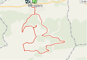
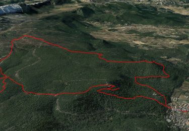
Randonnée Marche de 12,9 km à découvrir à Provence-Alpes-Côte d'Azur, Var, Rougiers. Cette randonnée est proposée par sonneville.
Description
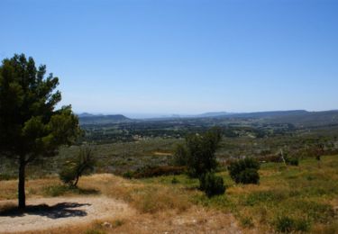
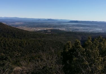
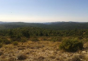
Beaucoup de grimpettes mais superbe sentier à travers la forêt.
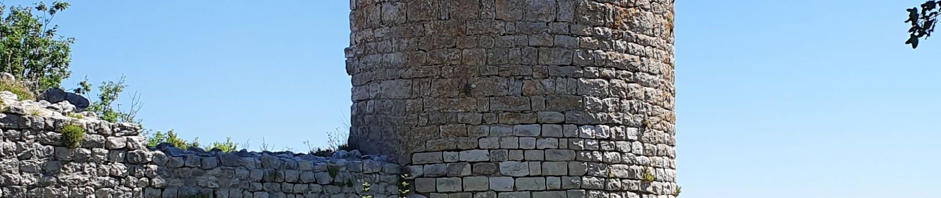
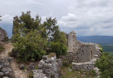
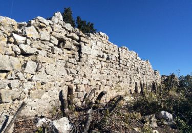
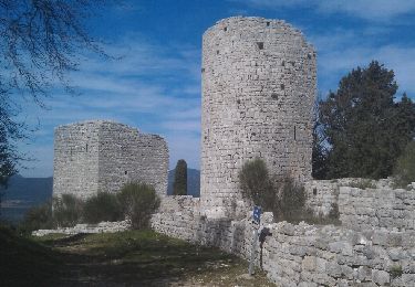
Passage aux ruines du Château et à la fontaine de la Guillandière.
La descente sur Rougiers est un un peu difficile
Localisation
Pays :
France
Région :
Provence-Alpes-Côte d'Azur
Département/Province :
Var
Commune :
Rougiers
Localité :
Unknown
Départ:(Dec)
Départ:(UTM)
730717 ; 4808343 (31T) N.
Commentaires
Randonnées à proximité
![Randonnée Marche Rougiers - Rougiers - Piegu , la fontaine de la Guillandière, le Castrum - Photo](https://media.geolcdn.com/t/375/260/81ba1a87-303b-4205-b673-8a1be5b2eb7f.jpg&format=jpg&maxdim=2)
![Marche Marche](https://static1.geolcdn.com/sitytour/trail-icons/101.png)
Rougiers - Piegu , la fontaine de la Guillandière, le Castrum
Marche
Moyen
(1)
Rougiers,
Provence-Alpes-Côte d'Azur,
Var,
France
![](/images/other/stat-length.png)
14,8 km | 22 km-effort
6h 0min
![](https://static1.geolcdn.com/siteimages/upload/files/16400158638029165_repeat_loop_refresh_sync_direction_icon.png)
Oui
![Randonnée V.T.T. Rougiers - Crêtes de la Sainte Baume et d'Agnis, l'intégrale à VTT - Photo](https://media.geolcdn.com/t/375/260/ext.jpg?maxdim=2&url=https%3A%2F%2Fservices.sitytrail.com%2FGeolivesWS%2FDownloadMedia.ashx%3FTrailID%3D105166%26Media%3D8794_3.jpg)
![V.T.T. V.T.T.](https://static1.geolcdn.com/sitytour/trail-icons/202.png)
Crêtes de la Sainte Baume et d'Agnis, l'intégrale à VTT
V.T.T.
Très difficile
(1)
Rougiers,
Provence-Alpes-Côte d'Azur,
Var,
France
![](/images/other/stat-length.png)
74 km | 105 km-effort
11h 0min
![](https://static1.geolcdn.com/siteimages/upload/files/16400158638029165_repeat_loop_refresh_sync_direction_icon.png)
Oui
![Randonnée Marche Rougiers - chapelle et ancien castrum de Saint-Jean - Photo](https://media.geolcdn.com/t/375/260/ext.jpg?maxdim=2&url=https%3A%2F%2Fservices.sitytrail.com%2FGeolivesWS%2FDownloadMedia.ashx%3FTrailID%3D979441%26Media%3Dfix__20180603133323.jpg)
![Marche Marche](https://static1.geolcdn.com/sitytour/trail-icons/101.png)
chapelle et ancien castrum de Saint-Jean
Marche
Facile
Rougiers,
Provence-Alpes-Côte d'Azur,
Var,
France
![](/images/other/stat-length.png)
6,9 km | 10,5 km-effort
2h 44min
![](https://static1.geolcdn.com/siteimages/upload/files/16400158638029165_repeat_loop_refresh_sync_direction_icon.png)
Oui
![Randonnée Marche Rougiers - rougiers - Photo](https://media.geolcdn.com/t/375/260/951277c3-a67c-4b11-a3e3-25df2e0589b7.jpg&format=jpg&maxdim=2)
![Marche Marche](https://static1.geolcdn.com/sitytour/trail-icons/101.png)
rougiers
Marche
Moyen
Rougiers,
Provence-Alpes-Côte d'Azur,
Var,
France
![](/images/other/stat-length.png)
14 km | 21 km-effort
4h 46min
![](https://static1.geolcdn.com/siteimages/upload/files/16400158638029165_repeat_loop_refresh_sync_direction_icon.png)
Oui
![Randonnée Marche Saint-Maximin-la-Sainte-Baume - M 6 fev mont Aurelien - Photo](https://media.geolcdn.com/t/375/260/52e4e2e1-2fc2-4f02-999d-52b8161f004a.jpg&format=jpg&maxdim=2)
![Marche Marche](https://static1.geolcdn.com/sitytour/trail-icons/101.png)
M 6 fev mont Aurelien
Marche
Moyen
Saint-Maximin-la-Sainte-Baume,
Provence-Alpes-Côte d'Azur,
Var,
France
![](/images/other/stat-length.png)
24 km | 34 km-effort
8h 5min
![](https://static1.geolcdn.com/siteimages/upload/files/16400158638029165_repeat_loop_refresh_sync_direction_icon.png)
Oui
![Randonnée Marche Rougiers - PF-Rougiers - L'Oppidum du Piégu-Le Castrum St Jean - Photo](https://media.geolcdn.com/t/375/260/ba93ca0b-4732-4dce-bbfb-08b477395c9c.jpg&format=jpg&maxdim=2)
![Marche Marche](https://static1.geolcdn.com/sitytour/trail-icons/101.png)
PF-Rougiers - L'Oppidum du Piégu-Le Castrum St Jean
Marche
Difficile
Rougiers,
Provence-Alpes-Côte d'Azur,
Var,
France
![](/images/other/stat-length.png)
15,2 km | 22 km-effort
6h 17min
![](https://static1.geolcdn.com/siteimages/upload/files/16400158638029165_repeat_loop_refresh_sync_direction_icon.png)
Oui
![Randonnée Marche Mazaugues - Barre de Mazaugues - Photo](https://media.geolcdn.com/t/375/260/ext.jpg?maxdim=2&url=https%3A%2F%2Fservices.sitytrail.com%2FGeolivesWS%2FDownloadMedia.ashx%3FTrailID%3D333730%26Media%3Dfix__20140812102118.jpg)
![Marche Marche](https://static1.geolcdn.com/sitytour/trail-icons/101.png)
Barre de Mazaugues
Marche
Moyen
Mazaugues,
Provence-Alpes-Côte d'Azur,
Var,
France
![](/images/other/stat-length.png)
10,5 km | 16,8 km-effort
3h 31min
![](https://static1.geolcdn.com/siteimages/upload/files/16400158638029165_repeat_loop_refresh_sync_direction_icon.png)
Non
![Randonnée Marche Tourves - Les poudaspes - Castrum de St jean - petite Valjencelle - Photo](https://media.geolcdn.com/t/375/260/ext.jpg?maxdim=2&url=https%3A%2F%2Fservices.sitytrail.com%2FGeolivesWS%2FDownloadMedia.ashx%3FTrailID%3D257740%26Media%3Dfix__20140316120316.jpg)
![Marche Marche](https://static1.geolcdn.com/sitytour/trail-icons/101.png)
Les poudaspes - Castrum de St jean - petite Valjencelle
Marche
Facile
(1)
Tourves,
Provence-Alpes-Côte d'Azur,
Var,
France
![](/images/other/stat-length.png)
13,6 km | 18,4 km-effort
2h 36min
![](https://static1.geolcdn.com/siteimages/upload/files/16400158638029165_repeat_loop_refresh_sync_direction_icon.png)
Oui
![Randonnée sport Nans-les-Pins - Nans ch de la menarguette - Photo](https://media.geolcdn.com/t/375/260/85debcb4-a3f1-4b43-ba79-6795bdae6353.jpg&format=jpg&maxdim=2)
Nans ch de la menarguette
sport
Très facile
Nans-les-Pins,
Provence-Alpes-Côte d'Azur,
Var,
France
![](/images/other/stat-length.png)
12,4 km | 18,2 km-effort
Inconnu
![](https://static1.geolcdn.com/siteimages/upload/files/16400158638029165_repeat_loop_refresh_sync_direction_icon.png)
Oui