![](/images/other/stat-length.png)
![Randonnée Marche Perwez - Balade à la campagne et à la lisière du bois - Photo](https://media.geolcdn.com/t/1900/400/9c9b3fcb-0a62-4d15-a976-2e2db581bd8e.jpg&format=pjpeg&maxdim=2)
Balade à la campagne et à la lisière du bois
philippe kessler
Utilisateur
![Longueur](/images/other/stat-length.png)
Longueur
6,9 km
![Altitude max](https://static1.geolcdn.com/siteimages/upload/files/1508320355ic_sort_altitude_max_24dp.png)
Altitude max
165 m
![Dénivelé positif](https://static1.geolcdn.com/siteimages/upload/files/1508320355ic_sort_den_pos_24dp.png)
Dénivelé positif
51 m
![Km-Effort](/images/other/stat-length.png)
Km-Effort
7,6 km
![Altitude min](https://static1.geolcdn.com/siteimages/upload/files/1508320355ic_sort_altitude_min_24dp.png)
Altitude min
146 m
![Dénivelé négatif](https://static1.geolcdn.com/siteimages/upload/files/1508320355ic_sort_den_neg_24dp.png)
Dénivelé négatif
51 m
![Boucle](https://static1.geolcdn.com/siteimages/upload/files/16400158638029165_repeat_loop_refresh_sync_direction_icon.png)
Boucle
Oui
Date de création :
2021-06-14 13:46:59.528
Dernière modification :
2021-06-14 13:56:08.809
![Marche](https://static1.geolcdn.com/sitytour/trail-icons/101.png)
1h44
Difficulté : Moyen
![Scannez ce code QR pour ouvrir la randonnée dans l'application SityTrail](https://capi.geolives.com/qq0zvz2zws4bq2lad0pu/sitytour/trails/2826763/qr.png?size=200)
Application GPS de randonnée GRATUITE
À propos
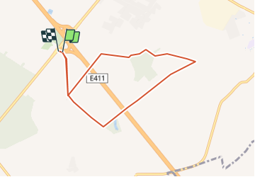
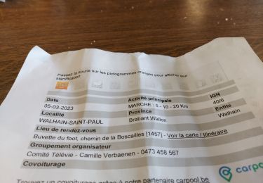
Randonnée Marche de 6,9 km à découvrir à Wallonie, Brabant wallon, Perwez. Cette randonnée est proposée par philippe kessler.
Description
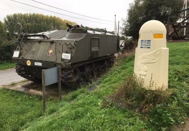
Parking de délestage au point de départ à proximité de l'autoroute E411, sortie Thorembais
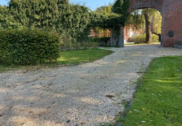
/- 600 mètres avant le retour au parking, possibilité de détente le long de la l'allée de la ferme
Localisation
Pays :
Belgique
Région :
Wallonie
Département/Province :
Brabant wallon
Commune :
Perwez
Localité :
Unknown
Départ:(Dec)
Départ:(UTM)
624590 ; 5609111 (31U) N.
Commentaires
Randonnées à proximité
![Randonnée Marche Gembloux - Promenade du bois de Grand-Leez et son étang - Photo](https://media.geolcdn.com/t/375/260/ba1705cc-caee-4df6-9c00-ffee46de9677.jpg&format=jpg&maxdim=2)
![Marche Marche](https://static1.geolcdn.com/sitytour/trail-icons/101.png)
Promenade du bois de Grand-Leez et son étang
Marche
Facile
(2)
Gembloux,
Wallonie,
Namur,
Belgique
![](/images/other/stat-length.png)
3,1 km | 3,6 km-effort
49min
![](https://static1.geolcdn.com/siteimages/upload/files/16400158638029165_repeat_loop_refresh_sync_direction_icon.png)
Oui
![Randonnée Marche Perwez - #230102 - Perwez > Ponceau, dont 4 km du GRP127 - Photo](https://media.geolcdn.com/t/375/260/ext.jpg?maxdim=2&url=https%3A%2F%2Fstatic1.geolcdn.com%2Fsiteimages%2Fupload%2Ffiles%2F1553511878bg_sport_marche.png)
![Marche Marche](https://static1.geolcdn.com/sitytour/trail-icons/101.png)
#230102 - Perwez > Ponceau, dont 4 km du GRP127
Marche
Très facile
(2)
Perwez,
Wallonie,
Brabant wallon,
Belgique
![](/images/other/stat-length.png)
7,2 km | 8 km-effort
Inconnu
![](https://static1.geolcdn.com/siteimages/upload/files/16400158638029165_repeat_loop_refresh_sync_direction_icon.png)
Oui
![V.T.T. V.T.T.](https://static1.geolcdn.com/sitytour/trail-icons/202.png)
VTT a la découverte de perwez
V.T.T.
Très facile
Perwez,
Wallonie,
Brabant wallon,
Belgique
![](/images/other/stat-length.png)
37 km | 41 km-effort
Inconnu
![](https://static1.geolcdn.com/siteimages/upload/files/16400158638029165_repeat_loop_refresh_sync_direction_icon.png)
Oui
![Randonnée Marche Perwez - w-belgie-la-balade-de-3-clochers - Photo](https://media.geolcdn.com/t/375/260/ext.jpg?maxdim=2&url=https%3A%2F%2Fstatic1.geolcdn.com%2Fsiteimages%2Fupload%2Ffiles%2F1553511878bg_sport_marche.png)
![Marche Marche](https://static1.geolcdn.com/sitytour/trail-icons/101.png)
w-belgie-la-balade-de-3-clochers
Marche
Très facile
(1)
Perwez,
Wallonie,
Brabant wallon,
Belgique
![](/images/other/stat-length.png)
7,8 km | 8,9 km-effort
Inconnu
![](https://static1.geolcdn.com/siteimages/upload/files/16400158638029165_repeat_loop_refresh_sync_direction_icon.png)
Oui
![Marche Marche](https://static1.geolcdn.com/sitytour/trail-icons/101.png)
#221014 - Orbais, balade de La Brigade Piron***
Marche
Moyen
(1)
Perwez,
Wallonie,
Brabant wallon,
Belgique
![](/images/other/stat-length.png)
7,4 km | 8,2 km-effort
1h 51min
![](https://static1.geolcdn.com/siteimages/upload/files/16400158638029165_repeat_loop_refresh_sync_direction_icon.png)
Oui
![Randonnée Marche Gembloux - autour de Grand-leez - Photo](https://media.geolcdn.com/t/375/260/a183186e-d7dc-481f-9ac2-9beeb32c3da6.jpg&format=jpg&maxdim=2)
![Marche Marche](https://static1.geolcdn.com/sitytour/trail-icons/101.png)
autour de Grand-leez
Marche
Facile
(1)
Gembloux,
Wallonie,
Namur,
Belgique
![](/images/other/stat-length.png)
7 km | 7,7 km-effort
2h 7min
![](https://static1.geolcdn.com/siteimages/upload/files/16400158638029165_repeat_loop_refresh_sync_direction_icon.png)
Oui
![Randonnée Marche Gembloux - ELVOBAL-GRAND LEEZ-11 KMS-mai 21. - Photo](https://media.geolcdn.com/t/375/260/ext.jpg?maxdim=2&url=https%3A%2F%2Fstatic1.geolcdn.com%2Fsiteimages%2Fupload%2Ffiles%2F1553511878bg_sport_marche.png)
![Marche Marche](https://static1.geolcdn.com/sitytour/trail-icons/101.png)
ELVOBAL-GRAND LEEZ-11 KMS-mai 21.
Marche
Moyen
(1)
Gembloux,
Wallonie,
Namur,
Belgique
![](/images/other/stat-length.png)
11,3 km | 12,4 km-effort
2h 34min
![](https://static1.geolcdn.com/siteimages/upload/files/16400158638029165_repeat_loop_refresh_sync_direction_icon.png)
Oui
![Randonnée Marche Walhain - PRJ n° 5 - Tourinnes-Saint-Lambert - Photo](https://media.geolcdn.com/t/375/260/ext.jpg?maxdim=2&url=https%3A%2F%2Fstatic1.geolcdn.com%2Fsiteimages%2Fupload%2Ffiles%2F1553511878bg_sport_marche.png)
![Marche Marche](https://static1.geolcdn.com/sitytour/trail-icons/101.png)
PRJ n° 5 - Tourinnes-Saint-Lambert
Marche
Facile
(2)
Walhain,
Wallonie,
Brabant wallon,
Belgique
![](/images/other/stat-length.png)
8,7 km | 9,5 km-effort
2h 7min
![](https://static1.geolcdn.com/siteimages/upload/files/16400158638029165_repeat_loop_refresh_sync_direction_icon.png)
Oui
![Randonnée Marche Walhain - WALHAIN-SAINT-PAUL _ Marche Adeps _ BBW _ 5/03/2023 - Photo](https://media.geolcdn.com/t/375/260/b8ca0d0f-b5da-45ef-ad00-e606fd687de4.jpg&format=jpg&maxdim=2)
![Marche Marche](https://static1.geolcdn.com/sitytour/trail-icons/101.png)
WALHAIN-SAINT-PAUL _ Marche Adeps _ BBW _ 5/03/2023
Marche
Facile
Walhain,
Wallonie,
Brabant wallon,
Belgique
![](/images/other/stat-length.png)
21 km | 23 km-effort
4h 49min
![](https://static1.geolcdn.com/siteimages/upload/files/16400158638029165_repeat_loop_refresh_sync_direction_icon.png)
Oui