![](/images/other/stat-length.png)
![Randonnée Marche Ambierle - Ambierle: la balade des enfants d'Ambierle - Photo](https://media.geolcdn.com/t/1900/400/50834d3f-154b-4417-87eb-38c03b05c648.jpg&format=pjpeg&maxdim=2)
Ambierle: la balade des enfants d'Ambierle
jpc42
Utilisateur
![Longueur](/images/other/stat-length.png)
Longueur
12,1 km
![Altitude max](https://static1.geolcdn.com/siteimages/upload/files/1508320355ic_sort_altitude_max_24dp.png)
Altitude max
544 m
![Dénivelé positif](https://static1.geolcdn.com/siteimages/upload/files/1508320355ic_sort_den_pos_24dp.png)
Dénivelé positif
389 m
![Km-Effort](/images/other/stat-length.png)
Km-Effort
17,3 km
![Altitude min](https://static1.geolcdn.com/siteimages/upload/files/1508320355ic_sort_altitude_min_24dp.png)
Altitude min
356 m
![Dénivelé négatif](https://static1.geolcdn.com/siteimages/upload/files/1508320355ic_sort_den_neg_24dp.png)
Dénivelé négatif
392 m
![Boucle](https://static1.geolcdn.com/siteimages/upload/files/16400158638029165_repeat_loop_refresh_sync_direction_icon.png)
Boucle
Oui
Date de création :
2021-06-09 07:00:40.774
Dernière modification :
2021-06-09 07:22:37.133
![Marche](https://static1.geolcdn.com/sitytour/trail-icons/101.png)
3h00
Difficulté : Difficile
![Scannez ce code QR pour ouvrir la randonnée dans l'application SityTrail](https://capi.geolives.com/qq0zvz2zws4bq2lad0pu/sitytour/trails/2819851/qr.png?size=200)
Application GPS de randonnée GRATUITE
À propos
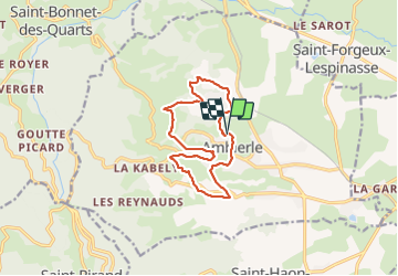
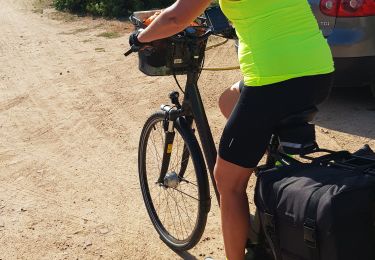
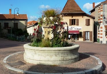
Randonnée Marche de 12,1 km à découvrir à Auvergne-Rhône-Alpes, Loire, Ambierle. Cette randonnée est proposée par jpc42.
Description
Marche libre organisée par le sous des écoles d'Ambierle
Départ parking salle de sport, à proximité des écoles.
Circuit réalisé en juin 2021. Sentiers permanents mais pas tous entretenus.
Localisation
Pays :
France
Région :
Auvergne-Rhône-Alpes
Département/Province :
Loire
Commune :
Ambierle
Localité :
Unknown
Départ:(Dec)
Départ:(UTM)
569150 ; 5106283 (31T) N.
Commentaires
Randonnées à proximité
![Randonnée Marche Saint-Rirand - La Croix du Sud, le bois blanc - Photo](https://media.geolcdn.com/t/375/260/ext.jpg?maxdim=2&url=https%3A%2F%2Fstatic1.geolcdn.com%2Fsiteimages%2Fupload%2Ffiles%2F1553511878bg_sport_marche.png)
![Marche Marche](https://static1.geolcdn.com/sitytour/trail-icons/101.png)
La Croix du Sud, le bois blanc
Marche
Facile
(3)
Saint-Rirand,
Auvergne-Rhône-Alpes,
Loire,
France
![](/images/other/stat-length.png)
8,2 km | 11,8 km-effort
2h 5min
![](https://static1.geolcdn.com/siteimages/upload/files/16400158638029165_repeat_loop_refresh_sync_direction_icon.png)
Oui
![Randonnée Marche Saint-Rirand - becajat depuis la croix du sud - Photo](https://media.geolcdn.com/t/375/260/e9d67ecd-6dca-4448-913e-4a4c29f2e0b6.jpg&format=jpg&maxdim=2)
![Marche Marche](https://static1.geolcdn.com/sitytour/trail-icons/101.png)
becajat depuis la croix du sud
Marche
Moyen
Saint-Rirand,
Auvergne-Rhône-Alpes,
Loire,
France
![](/images/other/stat-length.png)
8 km | 11,7 km-effort
2h 40min
![](https://static1.geolcdn.com/siteimages/upload/files/16400158638029165_repeat_loop_refresh_sync_direction_icon.png)
Oui
![Randonnée Marche Saint-Bonnet-des-Quarts - Ambierle : Bancheret - Servajeans - Photo](https://media.geolcdn.com/t/375/260/15d31ecc-6caf-4299-adf7-977f4f701dfd.jpg&format=jpg&maxdim=2)
![Marche Marche](https://static1.geolcdn.com/sitytour/trail-icons/101.png)
Ambierle : Bancheret - Servajeans
Marche
Difficile
Saint-Bonnet-des-Quarts,
Auvergne-Rhône-Alpes,
Loire,
France
![](/images/other/stat-length.png)
10,1 km | 16 km-effort
3h 37min
![](https://static1.geolcdn.com/siteimages/upload/files/16400158638029165_repeat_loop_refresh_sync_direction_icon.png)
Oui
![Randonnée Marche Saint-Rirand - St Rirand 20km - Photo](https://media.geolcdn.com/t/375/260/51386716-e082-4d06-8c45-7728bed37f2f.jpg&format=jpg&maxdim=2)
![Marche Marche](https://static1.geolcdn.com/sitytour/trail-icons/101.png)
St Rirand 20km
Marche
Difficile
Saint-Rirand,
Auvergne-Rhône-Alpes,
Loire,
France
![](/images/other/stat-length.png)
20 km | 29 km-effort
6h 0min
![](https://static1.geolcdn.com/siteimages/upload/files/16400158638029165_repeat_loop_refresh_sync_direction_icon.png)
Oui
![Randonnée Course à pied Ambierle - jour 6 CAP Jeanot - Photo](https://media.geolcdn.com/t/375/260/c02c6250-3a4e-4528-a836-6173a880ce7c.jpg&format=jpg&maxdim=2)
![Course à pied Course à pied](https://static1.geolcdn.com/sitytour/trail-icons/103.png)
jour 6 CAP Jeanot
Course à pied
Très facile
Ambierle,
Auvergne-Rhône-Alpes,
Loire,
France
![](/images/other/stat-length.png)
28 km | 38 km-effort
3h 0min
![](https://static1.geolcdn.com/siteimages/upload/files/16400158638029165_repeat_loop_refresh_sync_direction_icon.png)
Non
![Randonnée V.T.T. Ambierle - VTT sur les Monts de la Madeleine - Ambierle - Photo](https://media.geolcdn.com/t/375/260/ext.jpg?maxdim=2&url=https%3A%2F%2Fservices.sitytrail.com%2FGeolivesWS%2FDownloadMedia.ashx%3FTrailID%3D107318%26Media%3D12209_5.jpg)
![V.T.T. V.T.T.](https://static1.geolcdn.com/sitytour/trail-icons/202.png)
VTT sur les Monts de la Madeleine - Ambierle
V.T.T.
Très difficile
(2)
Ambierle,
Auvergne-Rhône-Alpes,
Loire,
France
![](/images/other/stat-length.png)
41 km | 60 km-effort
4h 0min
![](https://static1.geolcdn.com/siteimages/upload/files/16400158638029165_repeat_loop_refresh_sync_direction_icon.png)
Oui
![Randonnée Marche Changy - Le tour de pont Demain - Photo](https://media.geolcdn.com/t/375/260/8e3a5c40-91f8-4579-99ac-970c950c05d9.jpg&format=jpg&maxdim=2)
![Marche Marche](https://static1.geolcdn.com/sitytour/trail-icons/101.png)
Le tour de pont Demain
Marche
Difficile
Changy,
Auvergne-Rhône-Alpes,
Loire,
France
![](/images/other/stat-length.png)
13,4 km | 18,5 km-effort
3h 54min
![](https://static1.geolcdn.com/siteimages/upload/files/16400158638029165_repeat_loop_refresh_sync_direction_icon.png)
Oui
![Randonnée V.T.T. Ambierle - D'Ambierle à la Croix du Sud - Photo](https://media.geolcdn.com/t/375/260/ext.jpg?maxdim=2&url=https%3A%2F%2Fstatic1.geolcdn.com%2Fsiteimages%2Fupload%2Ffiles%2F1524743154velo.jpg)
![V.T.T. V.T.T.](https://static1.geolcdn.com/sitytour/trail-icons/202.png)
D'Ambierle à la Croix du Sud
V.T.T.
Difficile
Ambierle,
Auvergne-Rhône-Alpes,
Loire,
France
![](/images/other/stat-length.png)
24 km | 34 km-effort
2h 20min
![](https://static1.geolcdn.com/siteimages/upload/files/16400158638029165_repeat_loop_refresh_sync_direction_icon.png)
Oui
![Randonnée Marche Saint-Haon-le-Châtel - Compostelle St-Haon Le Chatel - Montarcher - Photo](https://media.geolcdn.com/t/375/260/ext.jpg?maxdim=2&url=https%3A%2F%2Fstatic1.geolcdn.com%2Fsiteimages%2Fupload%2Ffiles%2F1553511878bg_sport_marche.png)
![Marche Marche](https://static1.geolcdn.com/sitytour/trail-icons/101.png)
Compostelle St-Haon Le Chatel - Montarcher
Marche
Très difficile
Saint-Haon-le-Châtel,
Auvergne-Rhône-Alpes,
Loire,
France
![](/images/other/stat-length.png)
102 km | 131 km-effort
29h 47min
![](https://static1.geolcdn.com/siteimages/upload/files/16400158638029165_repeat_loop_refresh_sync_direction_icon.png)
Non