![](/images/other/stat-length.png)
![Randonnée A pied Boussy-Saint-Antoine - L 32: Boussy St Antoine l'Yerres et le Gord - Photo](https://media.geolcdn.com/t/1900/400/0167f6d8-7862-4a56-9e45-6680bff9395f.jpg&format=pjpeg&maxdim=2)
L 32: Boussy St Antoine l'Yerres et le Gord
Les 1000 pattes
Club randonnées SERVON
![Longueur](/images/other/stat-length.png)
Longueur
6,2 km
![Altitude max](https://static1.geolcdn.com/siteimages/upload/files/1508320355ic_sort_altitude_max_24dp.png)
Altitude max
83 m
![Dénivelé positif](https://static1.geolcdn.com/siteimages/upload/files/1508320355ic_sort_den_pos_24dp.png)
Dénivelé positif
76 m
![Km-Effort](/images/other/stat-length.png)
Km-Effort
7,2 km
![Altitude min](https://static1.geolcdn.com/siteimages/upload/files/1508320355ic_sort_altitude_min_24dp.png)
Altitude min
41 m
![Dénivelé négatif](https://static1.geolcdn.com/siteimages/upload/files/1508320355ic_sort_den_neg_24dp.png)
Dénivelé négatif
77 m
![Boucle](https://static1.geolcdn.com/siteimages/upload/files/16400158638029165_repeat_loop_refresh_sync_direction_icon.png)
Boucle
Oui
Date de création :
2021-06-08 12:53:06.019
Dernière modification :
2022-11-30 15:00:24.413
![A pied](https://static1.geolcdn.com/sitytour/trail-icons/100.png)
1h38
Difficulté : Très facile
![Scannez ce code QR pour ouvrir la randonnée dans l'application SityTrail](https://capi.geolives.com/qq0zvz2zws4bq2lad0pu/sitytour/trails/2819035/qr.png?size=200)
Application GPS de randonnée GRATUITE
À propos
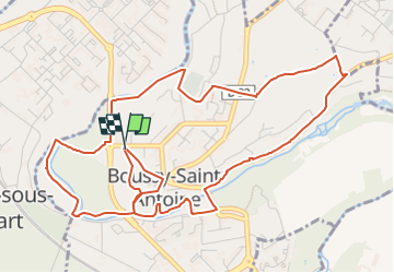
Randonnée A pied de 6,2 km à découvrir à Île-de-France, Essonne, Boussy-Saint-Antoine. Cette randonnée est proposée par Les 1000 pattes.
Description
Parking Rue de Rochopt à Boussy St Antoine (en face de la piscine)
Trajet Servon-->Boussy ( 7km:12mn)
Localisation
Pays :
France
Région :
Île-de-France
Département/Province :
Essonne
Commune :
Boussy-Saint-Antoine
Localité :
Unknown
Départ:(Dec)
Départ:(UTM)
465166 ; 5393186 (31U) N.
Commentaires
Randonnées à proximité
![Randonnée Marche Servon - J 22 12.00 km Lésigny intempéries - Photo](https://media.geolcdn.com/t/375/260/ext.jpg?maxdim=2&url=https%3A%2F%2Fstatic1.geolcdn.com%2Fsiteimages%2Fupload%2Ffiles%2F1553511878bg_sport_marche.png)
![Marche Marche](https://static1.geolcdn.com/sitytour/trail-icons/101.png)
J 22 12.00 km Lésigny intempéries
Marche
Moyen
(5)
Servon,
Île-de-France,
Seine-et-Marne,
France
![](/images/other/stat-length.png)
12,6 km | 14,2 km-effort
3h 10min
![](https://static1.geolcdn.com/siteimages/upload/files/16400158638029165_repeat_loop_refresh_sync_direction_icon.png)
Oui
![Randonnée A pied Villecresnes - L 20 boucle golf villecresnes et ancienne voie de chemin de fer - Photo](https://media.geolcdn.com/t/375/260/ext.jpg?maxdim=2&url=https%3A%2F%2Fstatic1.geolcdn.com%2Fsiteimages%2Fupload%2Ffiles%2F1545311037marcheuse_200dpi.jpg)
![A pied A pied](https://static1.geolcdn.com/sitytour/trail-icons/100.png)
L 20 boucle golf villecresnes et ancienne voie de chemin de fer
A pied
Très facile
(6)
Villecresnes,
Île-de-France,
Val-de-Marne,
France
![](/images/other/stat-length.png)
6,5 km | 7,7 km-effort
1h 44min
![](https://static1.geolcdn.com/siteimages/upload/files/16400158638029165_repeat_loop_refresh_sync_direction_icon.png)
Oui
![Randonnée A pied Servon - L 04 5.34 km Servon - Santeny et les étangs - Photo](https://media.geolcdn.com/t/375/260/b5894e46-d1cd-485b-a28c-446d5e91d239.jpg&format=jpg&maxdim=2)
![A pied A pied](https://static1.geolcdn.com/sitytour/trail-icons/100.png)
L 04 5.34 km Servon - Santeny et les étangs
A pied
Très facile
(6)
Servon,
Île-de-France,
Seine-et-Marne,
France
![](/images/other/stat-length.png)
6,6 km | 7,6 km-effort
1h 43min
![](https://static1.geolcdn.com/siteimages/upload/files/16400158638029165_repeat_loop_refresh_sync_direction_icon.png)
Oui
![Randonnée Marche Boussy-Saint-Antoine - GRP CV-IDF 15R Boussy-Saint-Antoine à Juvisy-sur-Orge - Photo](https://media.geolcdn.com/t/375/260/9a88b6b6-acb4-4798-9224-ae0478acaf21.jpg&format=jpg&maxdim=2)
![Marche Marche](https://static1.geolcdn.com/sitytour/trail-icons/101.png)
GRP CV-IDF 15R Boussy-Saint-Antoine à Juvisy-sur-Orge
Marche
Difficile
(1)
Boussy-Saint-Antoine,
Île-de-France,
Essonne,
France
![](/images/other/stat-length.png)
16,8 km | 18,6 km-effort
4h 13min
![](https://static1.geolcdn.com/siteimages/upload/files/16400158638029165_repeat_loop_refresh_sync_direction_icon.png)
Non
![Randonnée Marche Mandres-les-Roses - J 26 Mandres, Boussy , Brunoy le chemin des fresques - Photo](https://media.geolcdn.com/t/375/260/a7099e05-5a69-431c-83ab-49f9701f5dd5.jpg&format=jpg&maxdim=2)
![Marche Marche](https://static1.geolcdn.com/sitytour/trail-icons/101.png)
J 26 Mandres, Boussy , Brunoy le chemin des fresques
Marche
Moyen
(2)
Mandres-les-Roses,
Île-de-France,
Val-de-Marne,
France
![](/images/other/stat-length.png)
12,2 km | 13,8 km-effort
3h 7min
![](https://static1.geolcdn.com/siteimages/upload/files/16400158638029165_repeat_loop_refresh_sync_direction_icon.png)
Oui
![A pied A pied](https://static1.geolcdn.com/sitytour/trail-icons/100.png)
J 01 11.97 km les 5 châteaux
A pied
Facile
(3)
Servon,
Île-de-France,
Seine-et-Marne,
France
![](/images/other/stat-length.png)
11,3 km | 12,7 km-effort
2h 53min
![](https://static1.geolcdn.com/siteimages/upload/files/16400158638029165_repeat_loop_refresh_sync_direction_icon.png)
Oui
![Randonnée A pied Servon - R 04 - 8 km - Servon, Santeny, Servon - Photo](https://media.geolcdn.com/t/375/260/b334c7b2-5ac3-4f3d-879c-3237cd85e14e.jpg&format=jpg&maxdim=2)
![A pied A pied](https://static1.geolcdn.com/sitytour/trail-icons/100.png)
R 04 - 8 km - Servon, Santeny, Servon
A pied
Très difficile
(5)
Servon,
Île-de-France,
Seine-et-Marne,
France
![](/images/other/stat-length.png)
7,9 km | 9,1 km-effort
2h 3min
![](https://static1.geolcdn.com/siteimages/upload/files/16400158638029165_repeat_loop_refresh_sync_direction_icon.png)
Oui
![Randonnée Marche Yerres - BM Foret Regionale de Grobois 10km - Photo](https://media.geolcdn.com/t/375/260/ext.jpg?maxdim=2&url=https%3A%2F%2Fstatic1.geolcdn.com%2Fsiteimages%2Fupload%2Ffiles%2F1553511878bg_sport_marche.png)
![Marche Marche](https://static1.geolcdn.com/sitytour/trail-icons/101.png)
BM Foret Regionale de Grobois 10km
Marche
Moyen
(1)
Yerres,
Île-de-France,
Essonne,
France
![](/images/other/stat-length.png)
10,4 km | 11 km-effort
2h 30min
![](https://static1.geolcdn.com/siteimages/upload/files/16400158638029165_repeat_loop_refresh_sync_direction_icon.png)
Oui
![Randonnée Marche Yerres - BM Foret Regionale Grosbois 10km - Photo](https://media.geolcdn.com/t/375/260/ext.jpg?maxdim=2&url=https%3A%2F%2Fstatic1.geolcdn.com%2Fsiteimages%2Fupload%2Ffiles%2F1553511878bg_sport_marche.png)
![Marche Marche](https://static1.geolcdn.com/sitytour/trail-icons/101.png)
BM Foret Regionale Grosbois 10km
Marche
Moyen
(1)
Yerres,
Île-de-France,
Essonne,
France
![](/images/other/stat-length.png)
9,8 km | 10,5 km-effort
2h 23min
![](https://static1.geolcdn.com/siteimages/upload/files/16400158638029165_repeat_loop_refresh_sync_direction_icon.png)
Oui