Randonnée Marche Moncoutant-sur-Sèvre - Forêt de l aventure  - Photo
 viaul
viaul

Utilisateur GUIDE

© OpenStreetMap contributors
Longueur
Longueur
19,8 km
Altitude max
Altitude max
226 m
Dénivelé positif
Dénivelé positif
223 m
Km-Effort
Km-Effort  
23 km
Altitude min
Altitude min
174 m
Dénivelé négatif
Dénivelé négatif
224 m
Boucle
Boucle
Oui
Date de création :
2021-06-06 07:23:44.0
Dernière modification :
2021-06-06 12:55:09.692

(0 Avis)

Marche
Marche
5h31
Difficulté : Facile

Scannez ce code QR pour ouvrir la randonnée dans l'application SityTrail

Application GPS de randonnée GRATUITE

Logo SityTrail SityTrail

IGN / Instituts géographiques

Télécharger SityTrail sur l'App Store Télécharger SityTrail sur Google Play

Logo SityTrail SityTrail World

Le monde est à vous

Télécharger SityTrail sur l'App Store Télécharger SityTrail sur Google Play Télécharger SityTrail sur Huawei AppGallery

À propos

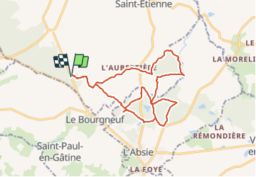
Randonnée Marche de 19,8 km à découvrir à Nouvelle-Aquitaine, Deux-Sèvres, Moncoutant-sur-Sèvre. Cette randonnée est proposée par viaul.

Description

Belle rando

Profil altimétrique

Localisation

Pays :
France
Région :
Nouvelle-Aquitaine
Département/Province :
Deux-Sèvres
Commune :
Moncoutant-sur-Sèvre
Localité :
La Chapelle-Saint-Étienne
Départ:(Dec)
Départ:(UTM)
682881 ; 5169903 (30T) N.

Randonnées à proximité

Randonnée A pied La Chapelle-aux-Lys - Chemin aux Étoiles - L'histoire de l'Univers - Photo
A pied
GUIDE+

A pied

Facile
La Chapelle-aux-Lys, Pays de la Loire, Vendée, France
4,3 km | 5,3 km-effort
1h 12min
Non
Randonnée Marche Moncoutant-sur-Sèvre - Rando 17km A-R de la forêt de l'aventure - Photo
Marche
dudu79

Marche

Très difficile
(1)
Moncoutant-sur-Sèvre, Nouvelle-Aquitaine, Deux-Sèvres, France
17,5 km | 21 km-effort
4h 50min
Oui
Randonnée Marche Moncoutant-sur-Sèvre - La Bonneliere - Photo
Marche
Bushiben

Marche

Très facile
Moncoutant-sur-Sèvre, Nouvelle-Aquitaine, Deux-Sèvres, France
12,4 km | 14,2 km-effort
4h 59min
Oui
Randonnée Marche Moncoutant-sur-Sèvre - Chante merle - Photo
Marche
GUIDE
viaul

Marche

Facile
Moncoutant-sur-Sèvre, Nouvelle-Aquitaine, Deux-Sèvres, France
12,2 km | 14 km-effort
3h 4min
Oui
Randonnée Marche Moncoutant-sur-Sèvre - Chante beau merle st Paul - Photo
Marche
GUIDE
viaul

Marche

Facile
Moncoutant-sur-Sèvre, Nouvelle-Aquitaine, Deux-Sèvres, France
18,3 km | 22 km-effort
4h 8min
Oui
Randonnée A pied Moncoutant-sur-Sèvre - rando du 23 mai 2021 - Photo
A pied
dudu79

A pied

Moyen
Moncoutant-sur-Sèvre, Nouvelle-Aquitaine, Deux-Sèvres, France
21 km | 26 km-effort
5h 54min
Oui
Randonnée Vélo Moncoutant-sur-Sèvre - Guérinière Bressuire 2 - Photo
Vélo
Ceclm

Vélo

Très facile
Moncoutant-sur-Sèvre, Nouvelle-Aquitaine, Deux-Sèvres, France
19,3 km | 21 km-effort
1h 0min
Non
Randonnée Quad La Chapelle-aux-Lys - rando 7 oct 23 - Photo
Quad
rabal85

Quad

Très facile
La Chapelle-aux-Lys, Pays de la Loire, Vendée, France
85 km | 102 km-effort
3h 8min
Non
Randonnée 4x4 La Chapelle-aux-Lys - semi nocturne  - Photo
4x4
favraux

4x4

Très facile
La Chapelle-aux-Lys, Pays de la Loire, Vendée, France
108 km | 129 km-effort
15h 31min
Non


Fermer
Mes abonnements