![](/images/other/stat-length.png)
![Randonnée Marche Gérardmer - GORGE DES ROITELETS - Photo](https://media.geolcdn.com/t/1900/400/ext.pjpeg?maxdim=2&url=https%3A%2F%2Fstatic1.geolcdn.com%2Fsiteimages%2Fupload%2Ffiles%2F1553511878bg_sport_marche.png)
GORGE DES ROITELETS
surceneux
Utilisateur
![Longueur](/images/other/stat-length.png)
Longueur
6,2 km
![Altitude max](https://static1.geolcdn.com/siteimages/upload/files/1508320355ic_sort_altitude_max_24dp.png)
Altitude max
773 m
![Dénivelé positif](https://static1.geolcdn.com/siteimages/upload/files/1508320355ic_sort_den_pos_24dp.png)
Dénivelé positif
213 m
![Km-Effort](/images/other/stat-length.png)
Km-Effort
9,1 km
![Altitude min](https://static1.geolcdn.com/siteimages/upload/files/1508320355ic_sort_altitude_min_24dp.png)
Altitude min
617 m
![Dénivelé négatif](https://static1.geolcdn.com/siteimages/upload/files/1508320355ic_sort_den_neg_24dp.png)
Dénivelé négatif
217 m
![Boucle](https://static1.geolcdn.com/siteimages/upload/files/16400158638029165_repeat_loop_refresh_sync_direction_icon.png)
Boucle
Oui
Date de création :
2021-06-01 13:39:44.87
Dernière modification :
2021-06-01 17:11:04.13
![Marche](https://static1.geolcdn.com/sitytour/trail-icons/101.png)
1h50
Difficulté : Moyen
![Scannez ce code QR pour ouvrir la randonnée dans l'application SityTrail](https://capi.geolives.com/qq0zvz2zws4bq2lad0pu/sitytour/trails/2810469/qr.png?size=200)
Application GPS de randonnée GRATUITE
À propos
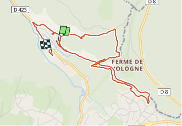
Randonnée Marche de 6,2 km à découvrir à Grand Est, Vosges, Gérardmer. Cette randonnée est proposée par surceneux.
Description
KICHOMPRE CENTRE BASSE DE L'OURS LA GLACIERE GRANGE DU CHENY GORGES DES ROITELETS LES VANNES PONT DES FEES KICHOMPRE
Localisation
Pays :
France
Région :
Grand Est
Département/Province :
Vosges
Commune :
Gérardmer
Localité :
Unknown
Départ:(Dec)
Départ:(UTM)
342703 ; 5328738 (32U) N.
Commentaires
Randonnées à proximité
![Randonnée Marche Gérardmer - gerardmer - la mauselaine . tête grauvelin . Roche boquet . croix claudé . hautes Vannes . la mauselaine - Photo](https://media.geolcdn.com/t/375/260/52e7d67b-2c25-481b-9a23-f7923e7ada1d.jpg&format=jpg&maxdim=2)
![Marche Marche](https://static1.geolcdn.com/sitytour/trail-icons/101.png)
gerardmer - la mauselaine . tête grauvelin . Roche boquet . croix claudé . ha...
Marche
Très facile
(1)
Gérardmer,
Grand Est,
Vosges,
France
![](/images/other/stat-length.png)
11,3 km | 16,2 km-effort
3h 42min
![](https://static1.geolcdn.com/siteimages/upload/files/16400158638029165_repeat_loop_refresh_sync_direction_icon.png)
Oui
![Randonnée Marche La Bresse - Lac de Lispach et sentier Dielaine - Photo](https://media.geolcdn.com/t/375/260/b54731ea-6209-4cff-b7c0-af5225a4f3ae.jpg&format=jpg&maxdim=2)
![Marche Marche](https://static1.geolcdn.com/sitytour/trail-icons/101.png)
Lac de Lispach et sentier Dielaine
Marche
Moyen
(1)
La Bresse,
Grand Est,
Vosges,
France
![](/images/other/stat-length.png)
9,7 km | 14,9 km-effort
2h 30min
![](https://static1.geolcdn.com/siteimages/upload/files/16400158638029165_repeat_loop_refresh_sync_direction_icon.png)
Oui
![Randonnée Marche nordique Gérardmer - ramonchamp. observatoire de merelle, saut de la bourrique - Photo](https://media.geolcdn.com/t/375/260/b9b6a61e-3e1c-46cb-91c9-2c5e6825ee89.jpg&format=jpg&maxdim=2)
![Marche nordique Marche nordique](https://static1.geolcdn.com/sitytour/trail-icons/102.png)
ramonchamp. observatoire de merelle, saut de la bourrique
Marche nordique
Difficile
(1)
Gérardmer,
Grand Est,
Vosges,
France
![](/images/other/stat-length.png)
11,1 km | 15,8 km-effort
3h 30min
![](https://static1.geolcdn.com/siteimages/upload/files/16400158638029165_repeat_loop_refresh_sync_direction_icon.png)
Oui
![Randonnée Marche Gérardmer - La Tête de Mérelle - Photo](https://media.geolcdn.com/t/375/260/ext.jpg?maxdim=2&url=https%3A%2F%2Fservices.sitytrail.com%2FGeolivesWS%2FDownloadMedia.ashx%3FTrailID%3D110294%26Media%3D5711_6.jpg)
![Marche Marche](https://static1.geolcdn.com/sitytour/trail-icons/101.png)
La Tête de Mérelle
Marche
Moyen
(5)
Gérardmer,
Grand Est,
Vosges,
France
![](/images/other/stat-length.png)
4,7 km | 9 km-effort
2h 30min
![](https://static1.geolcdn.com/siteimages/upload/files/16400158638029165_repeat_loop_refresh_sync_direction_icon.png)
Oui
![Randonnée Marche Gérardmer - 2018 05 24 obs Merelle - Photo](https://media.geolcdn.com/t/375/260/ext.jpg?maxdim=2&url=https%3A%2F%2Fservices.sitytrail.com%2FGeolivesWS%2FDownloadMedia.ashx%3FTrailID%3D973101%26Media%3Dfix__20180524120350.jpg)
![Marche Marche](https://static1.geolcdn.com/sitytour/trail-icons/101.png)
2018 05 24 obs Merelle
Marche
Moyen
(3)
Gérardmer,
Grand Est,
Vosges,
France
![](/images/other/stat-length.png)
11,5 km | 16,3 km-effort
4h 40min
![](https://static1.geolcdn.com/siteimages/upload/files/16400158638029165_repeat_loop_refresh_sync_direction_icon.png)
Oui
![Randonnée Marche Xonrupt-Longemer - 23-08-17 Lac Longemer - Lispach - Photo](https://media.geolcdn.com/t/375/260/ext.jpg?maxdim=2&url=https%3A%2F%2Fservices.sitytrail.com%2FGeolivesWS%2FDownloadMedia.ashx%3FTrailID%3D815971%26Media%3Dfix__20170823133945.jpg)
![Marche Marche](https://static1.geolcdn.com/sitytour/trail-icons/101.png)
23-08-17 Lac Longemer - Lispach
Marche
Moyen
(1)
Xonrupt-Longemer,
Grand Est,
Vosges,
France
![](/images/other/stat-length.png)
7 km | 12,1 km-effort
2h 13min
![](https://static1.geolcdn.com/siteimages/upload/files/16400158638029165_repeat_loop_refresh_sync_direction_icon.png)
Oui
![Randonnée Marche La Bresse - Lac de Lispach - Photo](https://media.geolcdn.com/t/375/260/ext.jpg?maxdim=2&url=https%3A%2F%2Fservices.sitytrail.com%2FGeolivesWS%2FDownloadMedia.ashx%3FTrailID%3D457358%26Media%3Dfix__20150811105157.jpg)
![Marche Marche](https://static1.geolcdn.com/sitytour/trail-icons/101.png)
Lac de Lispach
Marche
Facile
(1)
La Bresse,
Grand Est,
Vosges,
France
![](/images/other/stat-length.png)
2,1 km | 2,4 km-effort
44min
![](https://static1.geolcdn.com/siteimages/upload/files/16400158638029165_repeat_loop_refresh_sync_direction_icon.png)
Oui
![Randonnée Marche Xonrupt-Longemer - Le Hohneck et le sentier des roches - Du lac de Longemer au lac de Schiessrothried - Photo](https://media.geolcdn.com/t/375/260/ext.jpg?maxdim=2&url=https%3A%2F%2Fservices.sitytrail.com%2FGeolivesWS%2FDownloadMedia.ashx%3FTrailID%3D109636%26Media%3D4277_1.jpg)
![Marche Marche](https://static1.geolcdn.com/sitytour/trail-icons/101.png)
Le Hohneck et le sentier des roches - Du lac de Longemer au lac de Schiessrot...
Marche
Difficile
(1)
Xonrupt-Longemer,
Grand Est,
Vosges,
France
![](/images/other/stat-length.png)
15,7 km | 28 km-effort
7h 0min
![](https://static1.geolcdn.com/siteimages/upload/files/16400158638029165_repeat_loop_refresh_sync_direction_icon.png)
Non
![Randonnée Raquettes à neige Xonrupt-Longemer - Tour du Lispach - Longemer - Photo](https://media.geolcdn.com/t/375/260/ext.jpg?maxdim=2&url=https%3A%2F%2Fservices.sitytrail.com%2FGeolivesWS%2FDownloadMedia.ashx%3FTrailID%3D104732%26Media%3D8157_2.jpg)
![Raquettes à neige Raquettes à neige](https://static1.geolcdn.com/sitytour/trail-icons/504.png)
Tour du Lispach - Longemer
Raquettes à neige
Moyen
(2)
Xonrupt-Longemer,
Grand Est,
Vosges,
France
![](/images/other/stat-length.png)
3,2 km | 6,6 km-effort
2h 0min
![](https://static1.geolcdn.com/siteimages/upload/files/16400158638029165_repeat_loop_refresh_sync_direction_icon.png)
Oui