![](/images/other/stat-length.png)
![Randonnée Marche Fournols - Les deux frères - Photo](https://media.geolcdn.com/t/1900/400/850e86b7-5776-4c3c-9003-306cd3798dc6.jpg&format=pjpeg&maxdim=2)
Les deux frères
Gegetop
Utilisateur
![Longueur](/images/other/stat-length.png)
![Altitude max](https://static1.geolcdn.com/siteimages/upload/files/1508320355ic_sort_altitude_max_24dp.png)
![Dénivelé positif](https://static1.geolcdn.com/siteimages/upload/files/1508320355ic_sort_den_pos_24dp.png)
![Km-Effort](/images/other/stat-length.png)
![Altitude min](https://static1.geolcdn.com/siteimages/upload/files/1508320355ic_sort_altitude_min_24dp.png)
![Dénivelé négatif](https://static1.geolcdn.com/siteimages/upload/files/1508320355ic_sort_den_neg_24dp.png)
![Boucle](https://static1.geolcdn.com/siteimages/upload/files/16400158638029165_repeat_loop_refresh_sync_direction_icon.png)
![Marche](https://static1.geolcdn.com/sitytour/trail-icons/101.png)
4h15
Difficulté : Moyen
![Marche nordique](https://static1.geolcdn.com/sitytour/trail-icons/102.png)
3h50
Difficulté : Moyen
![Scannez ce code QR pour ouvrir la randonnée dans l'application SityTrail](https://capi.geolives.com/qq0zvz2zws4bq2lad0pu/sitytour/trails/2808673/qr.png?size=200)
Application GPS de randonnée GRATUITE
À propos
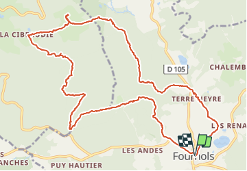
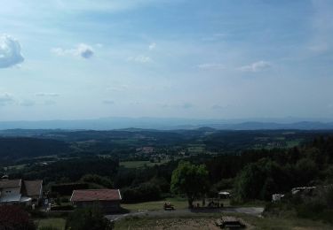
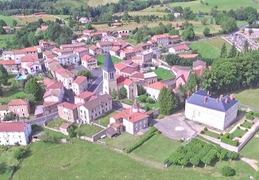
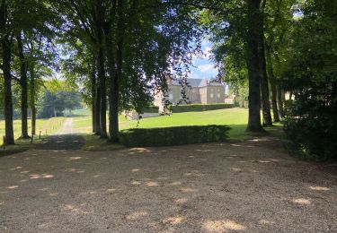
Randonnée Marche de 14,8 km à découvrir à Auvergne-Rhône-Alpes, Puy-de-Dôme, Fournols. Cette randonnée est proposée par Gegetop.
Description
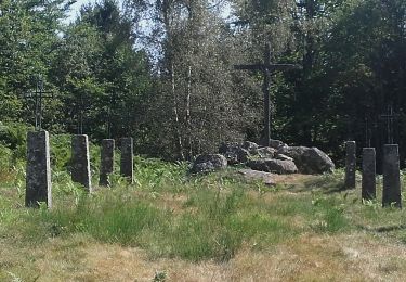
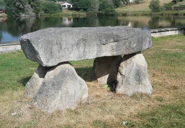
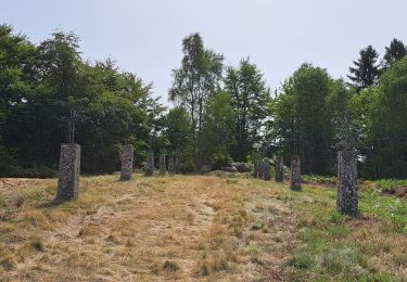
Randonnée n.45 de l'ancien guide Chamina.
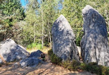
La forêt de Boigrand présente diverses essences resineuses, épicéa, mélèze, douglas mais aussi des feuillus hêtres, bouleau, sorbier, à lisier, saule cependant, l'essence principale reste le sapin dont certains dépassent 40m.
Localisation
Commentaires
Randonnées à proximité
![Randonnée A pied Échandelys - Les Panoramas - Photo](https://media.geolcdn.com/t/375/260/b6c9543d-d4b0-4e45-81bf-a2b7f1258d7e.jpeg&format=jpg&maxdim=2)
![A pied A pied](https://static1.geolcdn.com/sitytour/trail-icons/100.png)
A pied
![](/images/other/stat-length.png)
![](https://static1.geolcdn.com/siteimages/upload/files/16400158638029165_repeat_loop_refresh_sync_direction_icon.png)
![Randonnée A pied Saint-Amant-Roche-Savine - Roche-Savine - Photo](https://media.geolcdn.com/t/375/260/33e2b6f0-6c8c-409c-ab5f-7717ed153c10.jpeg&format=jpg&maxdim=2)
![A pied A pied](https://static1.geolcdn.com/sitytour/trail-icons/100.png)
A pied
![](/images/other/stat-length.png)
![](https://static1.geolcdn.com/siteimages/upload/files/16400158638029165_repeat_loop_refresh_sync_direction_icon.png)
![Randonnée A pied Fournols - Les Deux-Frères - Photo](https://media.geolcdn.com/t/375/260/d5784189-973d-43a7-a97f-cca4aab8ee4e.jpeg&format=jpg&maxdim=2)
![A pied A pied](https://static1.geolcdn.com/sitytour/trail-icons/100.png)
A pied
![](/images/other/stat-length.png)
![](https://static1.geolcdn.com/siteimages/upload/files/16400158638029165_repeat_loop_refresh_sync_direction_icon.png)
![Randonnée A pied Saint-Bonnet-le-Chastel - Frideroche - Photo](https://media.geolcdn.com/t/375/260/b327935d-e030-4733-947b-09de498f83c5.jpeg&format=jpg&maxdim=2)
![A pied A pied](https://static1.geolcdn.com/sitytour/trail-icons/100.png)
A pied
![](/images/other/stat-length.png)
![](https://static1.geolcdn.com/siteimages/upload/files/16400158638029165_repeat_loop_refresh_sync_direction_icon.png)
![Randonnée A pied Fournols - Fournols - Puy du Sapt - Photo](https://media.geolcdn.com/t/375/260/bb2da9db-eba2-4b2a-a77a-8a634280fa0e.jpeg&format=jpg&maxdim=2)
![A pied A pied](https://static1.geolcdn.com/sitytour/trail-icons/100.png)
A pied
![](/images/other/stat-length.png)
![](https://static1.geolcdn.com/siteimages/upload/files/16400158638029165_repeat_loop_refresh_sync_direction_icon.png)
![Randonnée Marche Échandelys - Echandelys_Panoramas - Photo](https://media.geolcdn.com/t/375/260/7ec13047-d9df-4116-9a4e-65cdef27f29f.jpg&format=jpg&maxdim=2)
![Marche Marche](https://static1.geolcdn.com/sitytour/trail-icons/101.png)
Marche
![](/images/other/stat-length.png)
![](https://static1.geolcdn.com/siteimages/upload/files/16400158638029165_repeat_loop_refresh_sync_direction_icon.png)
![Randonnée Marche Échandelys - Panorama en Livradois-Forez - Photo](https://media.geolcdn.com/t/375/260/34db6a6d-9e7c-42d5-8fbe-73bdf7138b85.jpg&format=jpg&maxdim=2)
![Marche Marche](https://static1.geolcdn.com/sitytour/trail-icons/101.png)
Marche
![](/images/other/stat-length.png)
![](https://static1.geolcdn.com/siteimages/upload/files/16400158638029165_repeat_loop_refresh_sync_direction_icon.png)
![Randonnée Marche Fournols - AUVERGNE 2023 Fournols - Les 2 frères - Photo](https://media.geolcdn.com/t/375/260/06e0f766-0d43-413d-a3a9-581028882a97.jpg&format=jpg&maxdim=2)
![Marche Marche](https://static1.geolcdn.com/sitytour/trail-icons/101.png)
Marche
![](/images/other/stat-length.png)
![](https://static1.geolcdn.com/siteimages/upload/files/16400158638029165_repeat_loop_refresh_sync_direction_icon.png)
![Randonnée Marche Chambon-sur-Dolore - AUVERGNE 2023 Chambon-Frideroche - Photo](https://media.geolcdn.com/t/375/260/a4b0d336-9190-4c1a-b453-a0896104ecdd.jpg&format=jpg&maxdim=2)
![Marche Marche](https://static1.geolcdn.com/sitytour/trail-icons/101.png)
Marche
![](/images/other/stat-length.png)
![](https://static1.geolcdn.com/siteimages/upload/files/16400158638029165_repeat_loop_refresh_sync_direction_icon.png)