![](/images/other/stat-length.png)
![Randonnée Vélo de route Lachapelle-sous-Aubenas - vélo route avec Marion - Photo](https://media.geolcdn.com/t/1900/400/ext.pjpeg?maxdim=2&url=https%3A%2F%2Fstatic1.geolcdn.com%2Fsiteimages%2Fupload%2Ffiles%2F1524743154velo.jpg)
vélo route avec Marion
Mariecoco
Utilisateur
![Longueur](/images/other/stat-length.png)
Longueur
16 km
![Altitude max](https://static1.geolcdn.com/siteimages/upload/files/1508320355ic_sort_altitude_max_24dp.png)
Altitude max
478 m
![Dénivelé positif](https://static1.geolcdn.com/siteimages/upload/files/1508320355ic_sort_den_pos_24dp.png)
Dénivelé positif
488 m
![Km-Effort](/images/other/stat-length.png)
Km-Effort
22 km
![Altitude min](https://static1.geolcdn.com/siteimages/upload/files/1508320355ic_sort_altitude_min_24dp.png)
Altitude min
193 m
![Dénivelé négatif](https://static1.geolcdn.com/siteimages/upload/files/1508320355ic_sort_den_neg_24dp.png)
Dénivelé négatif
280 m
![Boucle](https://static1.geolcdn.com/siteimages/upload/files/16400158638029165_repeat_loop_refresh_sync_direction_icon.png)
Boucle
Non
Date de création :
2021-05-28 08:38:36.939
Dernière modification :
2021-05-29 09:35:29.797
![Vélo de route](https://static1.geolcdn.com/sitytour/trail-icons/201.png)
9h00
Difficulté : Moyen
![Scannez ce code QR pour ouvrir la randonnée dans l'application SityTrail](https://capi.geolives.com/qq0zvz2zws4bq2lad0pu/sitytour/trails/2805965/qr.png?size=200)
Application GPS de randonnée GRATUITE
À propos
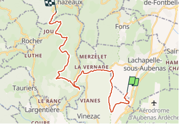
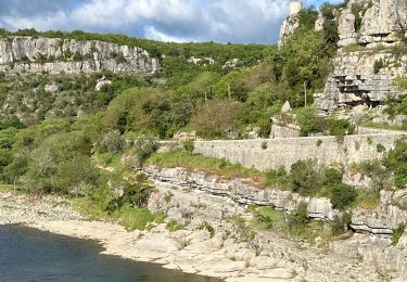
Randonnée Vélo de route de 16 km à découvrir à Auvergne-Rhône-Alpes, Ardèche, Lachapelle-sous-Aubenas. Cette randonnée est proposée par Mariecoco.
Description
la chapelle, la Vernade,la Davalade, Chazeaux,Lentillères, Ailhon, Fons, La Chapelle.
vélo route.
Localisation
Pays :
France
Région :
Auvergne-Rhône-Alpes
Département/Province :
Ardèche
Commune :
Lachapelle-sous-Aubenas
Localité :
Unknown
Départ:(Dec)
Départ:(UTM)
607378 ; 4933893 (31T) N.
Commentaires
Randonnées à proximité
![Randonnée Marche Largentière - 07 largentiere joannas taurier - Photo](https://media.geolcdn.com/t/375/260/77296687-ec5d-41c6-a098-e5d87fb442f3.jpg&format=jpg&maxdim=2)
![Marche Marche](https://static1.geolcdn.com/sitytour/trail-icons/101.png)
07 largentiere joannas taurier
Marche
Moyen
Largentière,
Auvergne-Rhône-Alpes,
Ardèche,
France
![](/images/other/stat-length.png)
24 km | 36 km-effort
8h 40min
![](https://static1.geolcdn.com/siteimages/upload/files/16400158638029165_repeat_loop_refresh_sync_direction_icon.png)
Oui
![Randonnée Marche Montréal - Le chemin des Fades Montréal - Photo](https://media.geolcdn.com/t/375/260/ext.jpg?maxdim=2&url=https%3A%2F%2Fstatic1.geolcdn.com%2Fsiteimages%2Fupload%2Ffiles%2F1553511878bg_sport_marche.png)
![Marche Marche](https://static1.geolcdn.com/sitytour/trail-icons/101.png)
Le chemin des Fades Montréal
Marche
Facile
(2)
Montréal,
Auvergne-Rhône-Alpes,
Ardèche,
France
![](/images/other/stat-length.png)
6,6 km | 9,3 km-effort
1h 51min
![](https://static1.geolcdn.com/siteimages/upload/files/16400158638029165_repeat_loop_refresh_sync_direction_icon.png)
Oui
![Randonnée Marche Balazuc - Balazuc Cirque de Gens 19km. - Photo](https://media.geolcdn.com/t/375/260/6d01c6fd-5949-41a2-b340-daa374c534bc.jpg&format=jpg&maxdim=2)
![Marche Marche](https://static1.geolcdn.com/sitytour/trail-icons/101.png)
Balazuc Cirque de Gens 19km.
Marche
Très difficile
Balazuc,
Auvergne-Rhône-Alpes,
Ardèche,
France
![](/images/other/stat-length.png)
19,2 km | 26 km-effort
5h 53min
![](https://static1.geolcdn.com/siteimages/upload/files/16400158638029165_repeat_loop_refresh_sync_direction_icon.png)
Oui
![Randonnée Marche Balazuc - Balazuc Servieres Viel-Audon 9km. - Photo](https://media.geolcdn.com/t/375/260/c62c36d0-f3c1-47de-a635-486a1871b8d7.jpg&format=jpg&maxdim=2)
![Marche Marche](https://static1.geolcdn.com/sitytour/trail-icons/101.png)
Balazuc Servieres Viel-Audon 9km.
Marche
Difficile
Balazuc,
Auvergne-Rhône-Alpes,
Ardèche,
France
![](/images/other/stat-length.png)
9 km | 12,7 km-effort
2h 53min
![](https://static1.geolcdn.com/siteimages/upload/files/16400158638029165_repeat_loop_refresh_sync_direction_icon.png)
Oui
![Randonnée sport Saint-Sernin - 2024-05-10_14h11m42_serre de vinobre - v3 (2) - Photo](https://media.geolcdn.com/t/375/260/ext.jpg?maxdim=2&url=https%3A%2F%2Fsecurestorage.geolives.com%2Fsitytour%2Ftrail-bg%2Fdefault.jpg)
2024-05-10_14h11m42_serre de vinobre - v3 (2)
sport
Très facile
(1)
Saint-Sernin,
Auvergne-Rhône-Alpes,
Ardèche,
France
![](/images/other/stat-length.png)
6,5 km | 9,1 km-effort
Inconnu
![](https://static1.geolcdn.com/siteimages/upload/files/16400158638029165_repeat_loop_refresh_sync_direction_icon.png)
Oui
![Randonnée sport Balazuc - Balazuc la tour de Jeanne le Viel Audon - Photo](https://media.geolcdn.com/t/375/260/d8c1c8fe-95e6-4adc-b1ae-0d66c200e42e.jpg&format=jpg&maxdim=2)
Balazuc la tour de Jeanne le Viel Audon
sport
Très facile
Balazuc,
Auvergne-Rhône-Alpes,
Ardèche,
France
![](/images/other/stat-length.png)
8,5 km | 12,3 km-effort
Inconnu
![](https://static1.geolcdn.com/siteimages/upload/files/16400158638029165_repeat_loop_refresh_sync_direction_icon.png)
Oui
![Randonnée Marche Montréal - 07_montreal_5-5km155m - Photo](https://media.geolcdn.com/t/375/260/66bf7ba6-c912-49cf-bf9e-2190ea7844b1.jpg&format=jpg&maxdim=2)
![Marche Marche](https://static1.geolcdn.com/sitytour/trail-icons/101.png)
07_montreal_5-5km155m
Marche
Facile
Montréal,
Auvergne-Rhône-Alpes,
Ardèche,
France
![](/images/other/stat-length.png)
5,6 km | 7,7 km-effort
1h 26min
![](https://static1.geolcdn.com/siteimages/upload/files/16400158638029165_repeat_loop_refresh_sync_direction_icon.png)
Oui
![Randonnée Marche Balazuc - 07_balazuc_5km210m - Photo](https://media.geolcdn.com/t/375/260/e481b746-68c2-4909-8202-14f51609cdb9.jpg&format=jpg&maxdim=2)
![Marche Marche](https://static1.geolcdn.com/sitytour/trail-icons/101.png)
07_balazuc_5km210m
Marche
Facile
Balazuc,
Auvergne-Rhône-Alpes,
Ardèche,
France
![](/images/other/stat-length.png)
5,2 km | 8 km-effort
1h 45min
![](https://static1.geolcdn.com/siteimages/upload/files/16400158638029165_repeat_loop_refresh_sync_direction_icon.png)
Oui
![Randonnée Vélo de route Vogüé - 07 j3 vogue - Photo](https://media.geolcdn.com/t/375/260/ac9eef10-04ef-4ebf-b837-e792d84c769a.jpg&format=jpg&maxdim=2)
![Vélo de route Vélo de route](https://static1.geolcdn.com/sitytour/trail-icons/201.png)
07 j3 vogue
Vélo de route
Moyen
Vogüé,
Auvergne-Rhône-Alpes,
Ardèche,
France
![](/images/other/stat-length.png)
71 km | 86 km-effort
6h 26min
![](https://static1.geolcdn.com/siteimages/upload/files/16400158638029165_repeat_loop_refresh_sync_direction_icon.png)
Non