Randonnée Marche Saint-Jean-de-Thurac - le noble arav - Photo
 mdns
mdns

Utilisateur

© OpenStreetMap contributors
Longueur
Longueur
3,8 km
Altitude max
Altitude max
172 m
Dénivelé positif
Dénivelé positif
119 m
Km-Effort
Km-Effort  
5,2 km
Altitude min
Altitude min
53 m
Dénivelé négatif
Dénivelé négatif
60 m
Boucle
Boucle
Non
Date de création :
2021-05-28 11:58:02.028
Dernière modification :
2021-05-28 14:38:21.086

(0 Avis)

Marche
Marche
1h06
Difficulté : Facile

Scannez ce code QR pour ouvrir la randonnée dans l'application SityTrail

Application GPS de randonnée GRATUITE

Logo SityTrail SityTrail

IGN / Instituts géographiques

Télécharger SityTrail sur l'App Store Télécharger SityTrail sur Google Play

Logo SityTrail SityTrail World

Le monde est à vous

Télécharger SityTrail sur l'App Store Télécharger SityTrail sur Google Play Télécharger SityTrail sur Huawei AppGallery

À propos

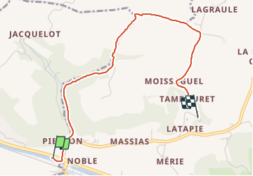
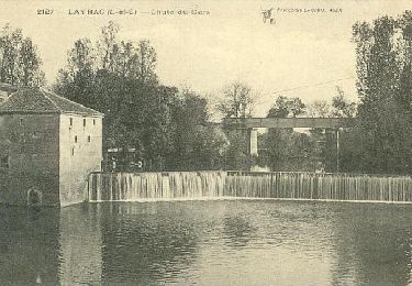
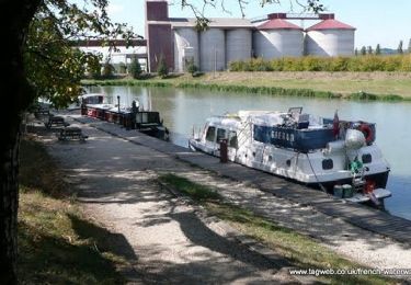
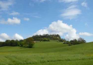
Randonnée Marche de 3,8 km à découvrir à Nouvelle-Aquitaine, Lot-et-Garonne, Saint-Jean-de-Thurac. Cette randonnée est proposée par mdns.

Profil altimétrique

Localisation

Pays :
France
Région :
Nouvelle-Aquitaine
Département/Province :
Lot-et-Garonne
Commune :
Saint-Jean-de-Thurac
Localité :
Unknown
Départ:(UTM)
320460 ; 4890947 (31T) N.

Randonnées à proximité

Randonnée Marche Castelculier - Saint-Amans / Saint-Ferréol, deux églises en Agenais - Pays de l'Agenais - Photo
Marche
tracegps

Marche

Moyen
(1)
Castelculier, Nouvelle-Aquitaine, Lot-et-Garonne, France
11,1 km | 15 km-effort
3h 0min
Oui
Randonnée V.T.T. Lafox - super rando du mercredi - Photo
V.T.T.
wardom

V.T.T.

Difficile
(1)
Lafox, Nouvelle-Aquitaine, Lot-et-Garonne, France
21 km | 26 km-effort
1h 29min
Oui
Randonnée V.T.T. Donzac - Les sentiers du Brulhois - Donzac - Photo
V.T.T.
tracegps

V.T.T.

Moyen
Donzac, Occitanie, Tarn-et-Garonne, France
40 km | 48 km-effort
2h 45min
Oui
Randonnée V.T.T. Castelculier - Rando VTT Amans - Laroque Timbaut et le bois de Courties - Agen Bon Encontre - Photo
V.T.T.
tracegps

V.T.T.

Difficile
Castelculier, Nouvelle-Aquitaine, Lot-et-Garonne, France
40 km | 50 km-effort
2h 30min
Oui
Randonnée V.T.T. Saint-Romain-le-Noble - St Romain le Noble / St Pierre de Clairac / Puymirol - Photo
V.T.T.
tracegps

V.T.T.

Difficile
Saint-Romain-le-Noble, Nouvelle-Aquitaine, Lot-et-Garonne, France
27 km | 36 km-effort
2h 0min
Oui
Randonnée V.T.T. Sauveterre-Saint-Denis - Sauveterre St Denis - Photo
V.T.T.
tracegps

V.T.T.

Moyen
Sauveterre-Saint-Denis, Nouvelle-Aquitaine, Lot-et-Garonne, France
30 km | 34 km-effort
2h 0min
Oui
Randonnée Marche Sauveterre-Saint-Denis - Sauveterre St Denis - Photo
Marche
tracegps

Marche

Très difficile
Sauveterre-Saint-Denis, Nouvelle-Aquitaine, Lot-et-Garonne, France
30 km | 34 km-effort
6h 0min
Oui
Randonnée Vélo Clermont-Soubiran - Voie Verte du Canal de Garonne - Laspeyres - Meilhan sur Garonne  - Photo
Vélo
tracegps

Vélo

Moyen
Clermont-Soubiran, Nouvelle-Aquitaine, Lot-et-Garonne, France
88 km | 98 km-effort
4h 30min
Non
Randonnée Cheval Saint-Romain-le-Noble - Saint-Romain-le-Noble, une succession de panoramas - Pays de l'Agenais - Photo
Cheval
tracegps

Cheval

Difficile
Saint-Romain-le-Noble, Nouvelle-Aquitaine, Lot-et-Garonne, France
13,8 km | 18,2 km-effort
2h 30min
Oui


Fermer
Mes abonnements