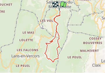
![](/images/other/stat-length.png)
![Randonnée Marche Saint-Nizier-du-Moucherotte - Trou Saint-Michel en circuit - Photo](https://media.geolcdn.com/t/1900/400/9d223443-968a-42a6-b711-1185df2b78c0.jpg&format=pjpeg&maxdim=2)
Trou Saint-Michel en circuit
Emelle
Utilisateur
![Longueur](/images/other/stat-length.png)
![Altitude max](https://static1.geolcdn.com/siteimages/upload/files/1508320355ic_sort_altitude_max_24dp.png)
![Dénivelé positif](https://static1.geolcdn.com/siteimages/upload/files/1508320355ic_sort_den_pos_24dp.png)
![Km-Effort](/images/other/stat-length.png)
![Altitude min](https://static1.geolcdn.com/siteimages/upload/files/1508320355ic_sort_altitude_min_24dp.png)
![Dénivelé négatif](https://static1.geolcdn.com/siteimages/upload/files/1508320355ic_sort_den_neg_24dp.png)
![Boucle](https://static1.geolcdn.com/siteimages/upload/files/16400158638029165_repeat_loop_refresh_sync_direction_icon.png)
![Marche](https://static1.geolcdn.com/sitytour/trail-icons/101.png)
5h31
Difficulté : Difficile
![Scannez ce code QR pour ouvrir la randonnée dans l'application SityTrail](https://capi.geolives.com/qq0zvz2zws4bq2lad0pu/sitytour/trails/2804046/qr.png?size=200)
Application GPS de randonnée GRATUITE
À propos
Randonnée Marche de 14,7 km à découvrir à Auvergne-Rhône-Alpes, Isère, Saint-Nizier-du-Moucherotte. Cette randonnée est proposée par Emelle.
Description
Montée par le pas de la Bergère assez raide
Retour par le pas de la Tinette
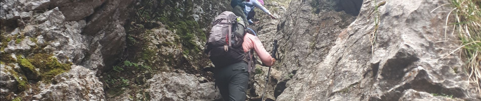
La difficulté vient principalement de la descente glissante et patinée en particulier dans le trou Saint-Michel à ne pas sous-estimer. 1er ressaut en désescalade délicat sans assurage, 2ème ressaut très glissant et patiné. Le mieux est de faire un rappel avec tout le matériel à prévoir : corde de 40 m, baudrier, casque, descendeur.
Localisation
Commentaires
Randonnées à proximité
![Randonnée Marche Sassenage - La ferme Durand - Photo](https://media.geolcdn.com/t/375/260/94c22489-8db0-4cec-b019-90eab5ac0fa3.jpg&format=jpg&maxdim=2)
![Marche Marche](https://static1.geolcdn.com/sitytour/trail-icons/101.png)
Marche
![](/images/other/stat-length.png)
![](https://static1.geolcdn.com/siteimages/upload/files/16400158638029165_repeat_loop_refresh_sync_direction_icon.png)
![Randonnée Marche nordique Seyssins - Seyssins le haut - Les Arcelles dans la neige - Photo](https://media.geolcdn.com/t/375/260/09832c62-e152-4e15-aea9-389ff5328b66.jpg&format=jpg&maxdim=2)
![Marche nordique Marche nordique](https://static1.geolcdn.com/sitytour/trail-icons/102.png)
Marche nordique
![](/images/other/stat-length.png)
![](https://static1.geolcdn.com/siteimages/upload/files/16400158638029165_repeat_loop_refresh_sync_direction_icon.png)
![Randonnée Marche Engins - Circuit pas de la Lose, du Tracollet, de l'Ours avec un retour par le passage de la Grande Combe - Photo](https://media.geolcdn.com/t/375/260/e578919b-c81c-4fe4-99cc-8260409f6f79.jpg&format=jpg&maxdim=2)
![Marche Marche](https://static1.geolcdn.com/sitytour/trail-icons/101.png)
Marche
![](/images/other/stat-length.png)
![](https://static1.geolcdn.com/siteimages/upload/files/16400158638029165_repeat_loop_refresh_sync_direction_icon.png)
![Randonnée Marche Seyssins - MOUCHEROTTE - Photo](https://media.geolcdn.com/t/375/260/fbc259ea-06fa-4a05-83ef-656dc650e275.jpg&format=jpg&maxdim=2)
![Marche Marche](https://static1.geolcdn.com/sitytour/trail-icons/101.png)
Marche
![](/images/other/stat-length.png)
![](https://static1.geolcdn.com/siteimages/upload/files/16400158638029165_repeat_loop_refresh_sync_direction_icon.png)
![Randonnée V.T.T. Seyssins - Petite escapade électrique au-dessus de 38 Seyssins - Photo](https://media.geolcdn.com/t/375/260/68bfc982-e63d-4725-88db-1e4968c2728b.jpg&format=jpg&maxdim=2)
![V.T.T. V.T.T.](https://static1.geolcdn.com/sitytour/trail-icons/202.png)
V.T.T.
![](/images/other/stat-length.png)
![](https://static1.geolcdn.com/siteimages/upload/files/16400158638029165_repeat_loop_refresh_sync_direction_icon.png)
![Randonnée Marche Fontaine - M le 20 cabane de Laura - Photo](https://media.geolcdn.com/t/375/260/40be2dc6-e0ec-4dac-a44e-b55a1a5b0b08.jpg&format=jpg&maxdim=2)
![Marche Marche](https://static1.geolcdn.com/sitytour/trail-icons/101.png)
Marche
![](/images/other/stat-length.png)
![](https://static1.geolcdn.com/siteimages/upload/files/16400158638029165_repeat_loop_refresh_sync_direction_icon.png)
![Randonnée Marche Lans-en-Vercors - Lans - Belvédère Vertige des Cimes depuis Le Furon - Photo](https://media.geolcdn.com/t/375/260/ext.jpg?maxdim=2&url=https%3A%2F%2Fservices.sitytrail.com%2FGeolivesWS%2FDownloadMedia.ashx%3FTrailID%3D661434%26Media%3Dfix__20161117114034.jpg)
![Marche Marche](https://static1.geolcdn.com/sitytour/trail-icons/101.png)
Marche
![](/images/other/stat-length.png)
![](https://static1.geolcdn.com/siteimages/upload/files/16400158638029165_repeat_loop_refresh_sync_direction_icon.png)
![Randonnée Raquettes à neige Lans-en-Vercors - Charande, La Molière par les Aigaux - Photo](https://media.geolcdn.com/t/375/260/ext.jpg?maxdim=2&url=https%3A%2F%2Fservices.sitytrail.com%2FGeolivesWS%2FDownloadMedia.ashx%3FTrailID%3D518560%26Media%3Dfix__20160128112605.jpg)
![Raquettes à neige Raquettes à neige](https://static1.geolcdn.com/sitytour/trail-icons/504.png)
Raquettes à neige
![](/images/other/stat-length.png)
![](https://static1.geolcdn.com/siteimages/upload/files/16400158638029165_repeat_loop_refresh_sync_direction_icon.png)
![Randonnée Course à pied Seyssinet-Pariset - 19 mai - Photo](https://media.geolcdn.com/t/375/260/ext.jpg?maxdim=2&url=https%3A%2F%2Fservices.sitytrail.com%2FGeolivesWS%2FDownloadMedia.ashx%3FTrailID%3D128561%26Media%3D20120519101643.jpg)
![Course à pied Course à pied](https://static1.geolcdn.com/sitytour/trail-icons/103.png)
Course à pied
![](/images/other/stat-length.png)
![](https://static1.geolcdn.com/siteimages/upload/files/16400158638029165_repeat_loop_refresh_sync_direction_icon.png)