![](/images/other/stat-length.png)
![Randonnée Marche Rouffignac-Saint-Cernin-de-Reilhac - Rouffignac - Dolmen Dou Cayre - Photo](https://media.geolcdn.com/t/1900/400/ext.pjpeg?maxdim=2&url=https%3A%2F%2Fmedia.geolcdn.com%2Ff%2Fbfda375a-1d42-4b91-95f9-c799f3e833f4.jpg)
Rouffignac - Dolmen Dou Cayre
jcc24
Utilisateur
![Longueur](/images/other/stat-length.png)
Longueur
2 km
![Altitude max](https://static1.geolcdn.com/siteimages/upload/files/1508320355ic_sort_altitude_max_24dp.png)
Altitude max
292 m
![Dénivelé positif](https://static1.geolcdn.com/siteimages/upload/files/1508320355ic_sort_den_pos_24dp.png)
Dénivelé positif
22 m
![Km-Effort](/images/other/stat-length.png)
Km-Effort
2,3 km
![Altitude min](https://static1.geolcdn.com/siteimages/upload/files/1508320355ic_sort_altitude_min_24dp.png)
Altitude min
270 m
![Dénivelé négatif](https://static1.geolcdn.com/siteimages/upload/files/1508320355ic_sort_den_neg_24dp.png)
Dénivelé négatif
23 m
![Boucle](https://static1.geolcdn.com/siteimages/upload/files/16400158638029165_repeat_loop_refresh_sync_direction_icon.png)
Boucle
Non
Date de création :
2021-05-26 09:01:16.341
Dernière modification :
2021-05-26 10:24:18.928
![Marche](https://static1.geolcdn.com/sitytour/trail-icons/101.png)
23m
Difficulté : Très facile
![Scannez ce code QR pour ouvrir la randonnée dans l'application SityTrail](https://capi.geolives.com/qq0zvz2zws4bq2lad0pu/sitytour/trails/2802234/qr.png?size=200)
Application GPS de randonnée GRATUITE
À propos
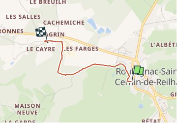
Randonnée Marche de 2 km à découvrir à Nouvelle-Aquitaine, Dordogne, Rouffignac-Saint-Cernin-de-Reilhac. Cette randonnée est proposée par jcc24.
Description
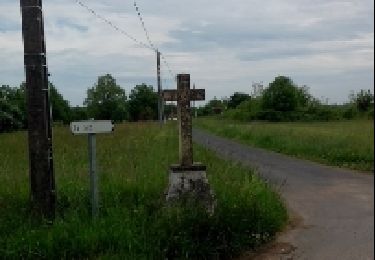
Circuit Aller/Retour depuis le parking du Cheylard (près de la pharmacie) à Rouffignac-St Cernin (4Km et 50 min au total pour l'aller/retour par le même chemin)
Localisation
Pays :
France
Région :
Nouvelle-Aquitaine
Département/Province :
Dordogne
Commune :
Rouffignac-Saint-Cernin-de-Reilhac
Localité :
Unknown
Départ:(Dec)
Départ:(UTM)
340584 ; 4990143 (31T) N.
Commentaires
Randonnées à proximité
![Randonnée Vélo électrique Plazac - Sensei Lissac - Photo](https://media.geolcdn.com/t/375/260/ext.jpg?maxdim=2&url=https%3A%2F%2Fmedia.geolcdn.com%2Ff%2Fccd27d5e-9d83-44d7-a1a6-a717ab1146ce.jpg)
![Vélo électrique Vélo électrique](https://static1.geolcdn.com/sitytour/trail-icons/205.png)
Sensei Lissac
Vélo électrique
Moyen
Plazac,
Nouvelle-Aquitaine,
Dordogne,
France
![](/images/other/stat-length.png)
18,7 km | 26 km-effort
2h 26min
![](https://static1.geolcdn.com/siteimages/upload/files/16400158638029165_repeat_loop_refresh_sync_direction_icon.png)
Oui
![Randonnée A pied Fleurac - Boucle de la Boissonie - Photo](https://media.geolcdn.com/t/375/260/ext.jpg?maxdim=2&url=https%3A%2F%2Fmedia.geolcdn.com%2Ff%2F10e99104-49c1-46cd-be73-6e6732ae592b.jpeg)
![A pied A pied](https://static1.geolcdn.com/sitytour/trail-icons/100.png)
Boucle de la Boissonie
A pied
Facile
Fleurac,
Nouvelle-Aquitaine,
Dordogne,
France
![](/images/other/stat-length.png)
6,1 km | 8,8 km-effort
1h 59min
![](https://static1.geolcdn.com/siteimages/upload/files/16400158638029165_repeat_loop_refresh_sync_direction_icon.png)
Oui
![Randonnée A pied Fleurac - Boucle de Lalande - Photo](https://media.geolcdn.com/t/375/260/ext.jpg?maxdim=2&url=https%3A%2F%2Fmedia.geolcdn.com%2Ff%2F10e99104-49c1-46cd-be73-6e6732ae592b.jpeg)
![A pied A pied](https://static1.geolcdn.com/sitytour/trail-icons/100.png)
Boucle de Lalande
A pied
Facile
Fleurac,
Nouvelle-Aquitaine,
Dordogne,
France
![](/images/other/stat-length.png)
14,1 km | 19,7 km-effort
4h 28min
![](https://static1.geolcdn.com/siteimages/upload/files/16400158638029165_repeat_loop_refresh_sync_direction_icon.png)
Oui
![Randonnée A pied Rouffignac-Saint-Cernin-de-Reilhac - Boucle des abîmes - Photo](https://media.geolcdn.com/t/375/260/ext.jpg?maxdim=2&url=https%3A%2F%2Fmedia.geolcdn.com%2Ff%2F4dd30409-8853-4b73-b349-60fe13b1888b.jpg)
![A pied A pied](https://static1.geolcdn.com/sitytour/trail-icons/100.png)
Boucle des abîmes
A pied
Facile
Rouffignac-Saint-Cernin-de-Reilhac,
Nouvelle-Aquitaine,
Dordogne,
France
![](/images/other/stat-length.png)
9,2 km | 11,1 km-effort
2h 30min
![](https://static1.geolcdn.com/siteimages/upload/files/16400158638029165_repeat_loop_refresh_sync_direction_icon.png)
Oui
![Randonnée Marche Saint-Geyrac - Boucle de la Forêt - Photo](https://media.geolcdn.com/t/375/260/ext.jpg?maxdim=2&url=https%3A%2F%2Fmedia.geolcdn.com%2Ff%2F4db006ff-30dc-4e31-b362-4edd70e8f0d5.jpg)
![Marche Marche](https://static1.geolcdn.com/sitytour/trail-icons/101.png)
Boucle de la Forêt
Marche
Difficile
Saint-Geyrac,
Nouvelle-Aquitaine,
Dordogne,
France
![](/images/other/stat-length.png)
13,1 km | 16,6 km-effort
3h 46min
![](https://static1.geolcdn.com/siteimages/upload/files/16400158638029165_repeat_loop_refresh_sync_direction_icon.png)
Oui
![Randonnée Marche Saint-Félix-de-Reillac-et-Mortemart - Boucle de Saint Félix - Photo](https://media.geolcdn.com/t/375/260/ext.jpg?maxdim=2&url=https%3A%2F%2Fmedia.geolcdn.com%2Ff%2Fcd974df2-0dd9-4210-a364-83bf5f943561.jpg)
![Marche Marche](https://static1.geolcdn.com/sitytour/trail-icons/101.png)
Boucle de Saint Félix
Marche
Difficile
Saint-Félix-de-Reillac-et-Mortemart,
Nouvelle-Aquitaine,
Dordogne,
France
![](/images/other/stat-length.png)
15,3 km | 18,8 km-effort
4h 16min
![](https://static1.geolcdn.com/siteimages/upload/files/16400158638029165_repeat_loop_refresh_sync_direction_icon.png)
Oui
![Randonnée Marche Rouffignac-Saint-Cernin-de-Reilhac - Rouffignac - Photo](https://media.geolcdn.com/t/375/260/ext.jpg?maxdim=2&url=https%3A%2F%2Fservices.sitytrail.com%2FGeolivesWS%2FDownloadMedia.ashx%3FTrailID%3D657120%26Media%3Dfix__20161106114513.jpg)
![Marche Marche](https://static1.geolcdn.com/sitytour/trail-icons/101.png)
Rouffignac
Marche
Facile
Rouffignac-Saint-Cernin-de-Reilhac,
Nouvelle-Aquitaine,
Dordogne,
France
![](/images/other/stat-length.png)
9,6 km | 11,5 km-effort
2h 21min
![](https://static1.geolcdn.com/siteimages/upload/files/16400158638029165_repeat_loop_refresh_sync_direction_icon.png)
Oui
![Randonnée Marche Rouffignac-Saint-Cernin-de-Reilhac - Rouffignac - Photo](https://media.geolcdn.com/t/375/260/ext.jpg?maxdim=2&url=https%3A%2F%2Fservices.sitytrail.com%2FGeolivesWS%2FDownloadMedia.ashx%3FTrailID%3D270154%26Media%3Dfix__20140424144531.jpg)
![Marche Marche](https://static1.geolcdn.com/sitytour/trail-icons/101.png)
Rouffignac
Marche
Facile
Rouffignac-Saint-Cernin-de-Reilhac,
Nouvelle-Aquitaine,
Dordogne,
France
![](/images/other/stat-length.png)
18 km | 23 km-effort
3h 58min
![](https://static1.geolcdn.com/siteimages/upload/files/16400158638029165_repeat_loop_refresh_sync_direction_icon.png)
Non
![Randonnée Marche Rouffignac-Saint-Cernin-de-Reilhac - château de l'herm - Photo](https://media.geolcdn.com/t/375/260/ext.jpg?maxdim=2&url=https%3A%2F%2Fmedia.geolcdn.com%2Ff%2Fce59a3f3-265d-436c-bc31-6690f3fb8fb6.jpg)
![Marche Marche](https://static1.geolcdn.com/sitytour/trail-icons/101.png)
château de l'herm
Marche
Très facile
Rouffignac-Saint-Cernin-de-Reilhac,
Nouvelle-Aquitaine,
Dordogne,
France
![](/images/other/stat-length.png)
6,7 km | 8,4 km-effort
1h 10min
![](https://static1.geolcdn.com/siteimages/upload/files/16400158638029165_repeat_loop_refresh_sync_direction_icon.png)
Oui