![](/images/other/stat-length.png)
![Randonnée Marche Naucelle - naucelle - Photo](https://media.geolcdn.com/t/1900/400/ext.pjpeg?maxdim=2&url=https%3A%2F%2Fstatic1.geolcdn.com%2Fsiteimages%2Fupload%2Ffiles%2F1553511878bg_sport_marche.png)
naucelle
Frayssinet
Utilisateur
![Longueur](/images/other/stat-length.png)
Longueur
23 km
![Altitude max](https://static1.geolcdn.com/siteimages/upload/files/1508320355ic_sort_altitude_max_24dp.png)
Altitude max
494 m
![Dénivelé positif](https://static1.geolcdn.com/siteimages/upload/files/1508320355ic_sort_den_pos_24dp.png)
Dénivelé positif
679 m
![Km-Effort](/images/other/stat-length.png)
Km-Effort
32 km
![Altitude min](https://static1.geolcdn.com/siteimages/upload/files/1508320355ic_sort_altitude_min_24dp.png)
Altitude min
304 m
![Dénivelé négatif](https://static1.geolcdn.com/siteimages/upload/files/1508320355ic_sort_den_neg_24dp.png)
Dénivelé négatif
680 m
![Boucle](https://static1.geolcdn.com/siteimages/upload/files/16400158638029165_repeat_loop_refresh_sync_direction_icon.png)
Boucle
Oui
Date de création :
2021-05-23 06:16:02.836
Dernière modification :
2021-05-23 16:23:28.365
![Marche](https://static1.geolcdn.com/sitytour/trail-icons/101.png)
5h36
Difficulté : Très difficile
![Scannez ce code QR pour ouvrir la randonnée dans l'application SityTrail](https://capi.geolives.com/qq0zvz2zws4bq2lad0pu/sitytour/trails/2798205/qr.png?size=200)
Application GPS de randonnée GRATUITE
À propos
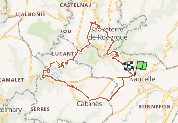
Randonnée Marche de 23 km à découvrir à Occitanie, Aveyron, Naucelle. Cette randonnée est proposée par Frayssinet.
Description
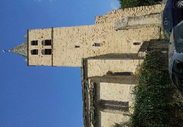
Départ de Naucelle, vers la Chapelle de Villelongue (musée de la résistance). Passage au moulin de Galie.
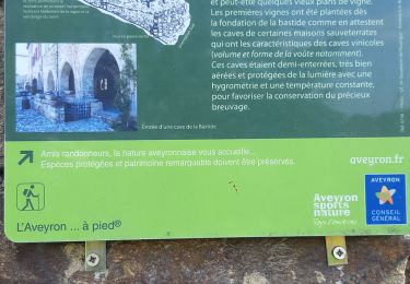
Montée vers Sauveterre en passant près d'Albagnac.
Retour classique vers Naucelle.
Ferme de Lamas et Anes vers le village de La Prade basse.
Localisation
Pays :
France
Région :
Occitanie
Département/Province :
Aveyron
Commune :
Naucelle
Localité :
Unknown
Départ:(Dec)
Départ:(UTM)
447033 ; 4894197 (31T) N.
Commentaires
Randonnées à proximité
![Randonnée A pied Quins - Quins 1 - Photo](https://media.geolcdn.com/t/375/260/71b85827-9f81-4d3c-b003-417d266e763f.jpeg&format=jpg&maxdim=2)
![A pied A pied](https://static1.geolcdn.com/sitytour/trail-icons/100.png)
![Randonnée A pied Quins - Quins 2 - Photo](https://media.geolcdn.com/t/375/260/71b85827-9f81-4d3c-b003-417d266e763f.jpeg&format=jpg&maxdim=2)
![A pied A pied](https://static1.geolcdn.com/sitytour/trail-icons/100.png)
![Randonnée Marche Sauveterre-de-Rouergue - la gazonne sauveterre la gazonne modifiée - Photo](https://media.geolcdn.com/t/375/260/f3101ce2-aeb3-4913-bb3e-79304ad58973.jpg&format=jpg&maxdim=2)
![Marche Marche](https://static1.geolcdn.com/sitytour/trail-icons/101.png)
la gazonne sauveterre la gazonne modifiée
Marche
Difficile
Sauveterre-de-Rouergue,
Occitanie,
Aveyron,
France
![](/images/other/stat-length.png)
9,8 km | 13,5 km-effort
2h 37min
![](https://static1.geolcdn.com/siteimages/upload/files/16400158638029165_repeat_loop_refresh_sync_direction_icon.png)
Oui
![Randonnée Marche Sauveterre-de-Rouergue - Sauveterre de Rouergue, au coeur du Ségala - Photo](https://media.geolcdn.com/t/375/260/ext.jpg?maxdim=2&url=https%3A%2F%2Fservices.sitytrail.com%2FGeolivesWS%2FDownloadMedia.ashx%3FTrailID%3D104126%26Media%3D7196_6.jpg)
![Marche Marche](https://static1.geolcdn.com/sitytour/trail-icons/101.png)
Sauveterre de Rouergue, au coeur du Ségala
Marche
Difficile
Sauveterre-de-Rouergue,
Occitanie,
Aveyron,
France
![](/images/other/stat-length.png)
15,1 km | 22 km-effort
4h 45min
![](https://static1.geolcdn.com/siteimages/upload/files/16400158638029165_repeat_loop_refresh_sync_direction_icon.png)
Oui
![Randonnée Marche Naucelle - Naucelle - Photo](https://media.geolcdn.com/t/375/260/816e6f2e-257d-4632-8a2c-1f988e32190f.jpg&format=jpg&maxdim=2)
![Marche Marche](https://static1.geolcdn.com/sitytour/trail-icons/101.png)
Naucelle
Marche
Très difficile
(1)
Naucelle,
Occitanie,
Aveyron,
France
![](/images/other/stat-length.png)
15 km | 21 km-effort
4h 52min
![](https://static1.geolcdn.com/siteimages/upload/files/16400158638029165_repeat_loop_refresh_sync_direction_icon.png)
Oui
![Randonnée Marche Naucelle - 2012-09-09 17h04m18 - Photo](https://media.geolcdn.com/t/375/260/ext.jpg?maxdim=2&url=https%3A%2F%2Fservices.sitytrail.com%2FGeolivesWS%2FDownloadMedia.ashx%3FTrailID%3D152846%26Media%3D20120909142702.jpeg)
![Marche Marche](https://static1.geolcdn.com/sitytour/trail-icons/101.png)
2012-09-09 17h04m18
Marche
Facile
(1)
Naucelle,
Occitanie,
Aveyron,
France
![](/images/other/stat-length.png)
11,7 km | 15,9 km-effort
4h 4min
![](https://static1.geolcdn.com/siteimages/upload/files/16400158638029165_repeat_loop_refresh_sync_direction_icon.png)
Oui
![Randonnée Marche Sauveterre-de-Rouergue - autour de sauveterre version courte - Photo](https://media.geolcdn.com/t/375/260/ext.jpg?maxdim=2&url=https%3A%2F%2Fstatic1.geolcdn.com%2Fsiteimages%2Fupload%2Ffiles%2F1553511878bg_sport_marche.png)
![Marche Marche](https://static1.geolcdn.com/sitytour/trail-icons/101.png)
autour de sauveterre version courte
Marche
Moyen
Sauveterre-de-Rouergue,
Occitanie,
Aveyron,
France
![](/images/other/stat-length.png)
7,3 km | 10,1 km-effort
2h 18min
![](https://static1.geolcdn.com/siteimages/upload/files/16400158638029165_repeat_loop_refresh_sync_direction_icon.png)
Oui
![Randonnée Marche Sauveterre-de-Rouergue - la gazonne sauveterre la gazonne - Photo](https://media.geolcdn.com/t/375/260/ext.jpg?maxdim=2&url=https%3A%2F%2Fstatic1.geolcdn.com%2Fsiteimages%2Fupload%2Ffiles%2F1553511878bg_sport_marche.png)
![Marche Marche](https://static1.geolcdn.com/sitytour/trail-icons/101.png)
la gazonne sauveterre la gazonne
Marche
Difficile
Sauveterre-de-Rouergue,
Occitanie,
Aveyron,
France
![](/images/other/stat-length.png)
9,3 km | 13,6 km-effort
3h 5min
![](https://static1.geolcdn.com/siteimages/upload/files/16400158638029165_repeat_loop_refresh_sync_direction_icon.png)
Oui
![Randonnée Marche Naucelle - Naucelle a La salvetat - Photo](https://media.geolcdn.com/t/375/260/ext.jpg?maxdim=2&url=https%3A%2F%2Fstatic1.geolcdn.com%2Fsiteimages%2Fupload%2Ffiles%2F1553511878bg_sport_marche.png)
![Marche Marche](https://static1.geolcdn.com/sitytour/trail-icons/101.png)
Naucelle a La salvetat
Marche
Facile
Naucelle,
Occitanie,
Aveyron,
France
![](/images/other/stat-length.png)
20 km | 28 km-effort
6h 25min
![](https://static1.geolcdn.com/siteimages/upload/files/16400158638029165_repeat_loop_refresh_sync_direction_icon.png)
Oui