![](/images/other/stat-length.png)
![Randonnée Marche Quincy-sous-Sénart - JC 29 Tigery, St Pierre du Perray, allée Royale - Photo](https://media.geolcdn.com/t/1900/400/5851b048-290f-41cf-bb5c-e913baf45afc.jpg&format=pjpeg&maxdim=2)
JC 29 Tigery, St Pierre du Perray, allée Royale
Les 1000 pattes
Club randonnées SERVON
![Longueur](/images/other/stat-length.png)
![Altitude max](https://static1.geolcdn.com/siteimages/upload/files/1508320355ic_sort_altitude_max_24dp.png)
![Dénivelé positif](https://static1.geolcdn.com/siteimages/upload/files/1508320355ic_sort_den_pos_24dp.png)
![Km-Effort](/images/other/stat-length.png)
![Altitude min](https://static1.geolcdn.com/siteimages/upload/files/1508320355ic_sort_altitude_min_24dp.png)
![Dénivelé négatif](https://static1.geolcdn.com/siteimages/upload/files/1508320355ic_sort_den_neg_24dp.png)
![Boucle](https://static1.geolcdn.com/siteimages/upload/files/16400158638029165_repeat_loop_refresh_sync_direction_icon.png)
![Marche](https://static1.geolcdn.com/sitytour/trail-icons/101.png)
5h14
Difficulté : Très difficile
![Scannez ce code QR pour ouvrir la randonnée dans l'application SityTrail](https://capi.geolives.com/qq0zvz2zws4bq2lad0pu/sitytour/trails/2796435/qr.png?size=200)
Application GPS de randonnée GRATUITE
À propos
Randonnée Marche de 21 km à découvrir à Île-de-France, Essonne, Quincy-sous-Sénart. Cette randonnée est proposée par Les 1000 pattes.
Description
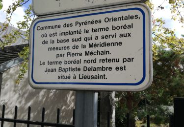
Parking carrefour de la Rue de la Libération ou D33 et de la Rue d'Orléans à Quincy sous Sénart, faire le tour de la Croix de Villeroy pour l'entrée du parking
GPS: Servon-->Rue de la Libération à Quincy sous Sénart
Trajet Servon-->Parking: 17km (15mn)
Localisation
Commentaires
Randonnées à proximité
![Randonnée Marche Boussy-Saint-Antoine - GRP CV-IDF 15R Boussy-Saint-Antoine à Juvisy-sur-Orge - Photo](https://media.geolcdn.com/t/375/260/9a88b6b6-acb4-4798-9224-ae0478acaf21.jpg&format=jpg&maxdim=2)
![Marche Marche](https://static1.geolcdn.com/sitytour/trail-icons/101.png)
Marche
![](/images/other/stat-length.png)
![](https://static1.geolcdn.com/siteimages/upload/files/16400158638029165_repeat_loop_refresh_sync_direction_icon.png)
![Randonnée Marche Mandres-les-Roses - J 26 Mandres, Boussy , Brunoy le chemin des fresques - Photo](https://media.geolcdn.com/t/375/260/a7099e05-5a69-431c-83ab-49f9701f5dd5.jpg&format=jpg&maxdim=2)
![Marche Marche](https://static1.geolcdn.com/sitytour/trail-icons/101.png)
Marche
![](/images/other/stat-length.png)
![](https://static1.geolcdn.com/siteimages/upload/files/16400158638029165_repeat_loop_refresh_sync_direction_icon.png)
![Randonnée A pied Tigery - L 23 Lieusaint, ruisseau des Heauldres, canal d'Ormoy - Photo](https://media.geolcdn.com/t/375/260/f8075a31-4ce3-4b81-a6e4-b6a4b3920940.jpg&format=jpg&maxdim=2)
![A pied A pied](https://static1.geolcdn.com/sitytour/trail-icons/100.png)
A pied
![](/images/other/stat-length.png)
![](https://static1.geolcdn.com/siteimages/upload/files/16400158638029165_repeat_loop_refresh_sync_direction_icon.png)
![Randonnée Marche Tigery - Ru des Hauldres - Photo](https://media.geolcdn.com/t/375/260/ext.jpg?maxdim=2&url=https%3A%2F%2Fstatic1.geolcdn.com%2Fsiteimages%2Fupload%2Ffiles%2F1553511878bg_sport_marche.png)
![Marche Marche](https://static1.geolcdn.com/sitytour/trail-icons/101.png)
Marche
![](/images/other/stat-length.png)
![](https://static1.geolcdn.com/siteimages/upload/files/16400158638029165_repeat_loop_refresh_sync_direction_icon.png)
![Randonnée A pied Brunoy - L 39 Brunoy, les bords de l'Yerres - Photo](https://media.geolcdn.com/t/375/260/ebb13649-b3e9-4bd9-9011-035537427274.jpg&format=jpg&maxdim=2)
![A pied A pied](https://static1.geolcdn.com/sitytour/trail-icons/100.png)
A pied
![](/images/other/stat-length.png)
![](https://static1.geolcdn.com/siteimages/upload/files/16400158638029165_repeat_loop_refresh_sync_direction_icon.png)
![Randonnée Marche Montgeron - J 38 Montgeron la Pelouse, forêt de Sénart - Photo](https://media.geolcdn.com/t/375/260/f009853b-b232-40f1-8161-c380b5b5f65c.jpg&format=jpg&maxdim=2)
![Marche Marche](https://static1.geolcdn.com/sitytour/trail-icons/101.png)
Marche
![](/images/other/stat-length.png)
![](https://static1.geolcdn.com/siteimages/upload/files/16400158638029165_repeat_loop_refresh_sync_direction_icon.png)
![Randonnée A pied Quincy-sous-Sénart - J 77 Tigery, Allée Royale - Photo](https://media.geolcdn.com/t/375/260/0a515c89-1783-41f2-919a-9dc7db91522b.jpg&format=jpg&maxdim=2)
![A pied A pied](https://static1.geolcdn.com/sitytour/trail-icons/100.png)
A pied
![](/images/other/stat-length.png)
![](https://static1.geolcdn.com/siteimages/upload/files/16400158638029165_repeat_loop_refresh_sync_direction_icon.png)
![Randonnée A pied Boussy-Saint-Antoine - L 32: Boussy St Antoine l'Yerres et le Gord - Photo](https://media.geolcdn.com/t/375/260/0167f6d8-7862-4a56-9e45-6680bff9395f.jpg&format=jpg&maxdim=2)
![A pied A pied](https://static1.geolcdn.com/sitytour/trail-icons/100.png)
A pied
![](/images/other/stat-length.png)
![](https://static1.geolcdn.com/siteimages/upload/files/16400158638029165_repeat_loop_refresh_sync_direction_icon.png)
![Randonnée Marche Yerres - J 43 Yerres Parc Caillebotte, île des Prévôts - Photo](https://media.geolcdn.com/t/375/260/3326873b-9942-4059-9e6b-fa272d49fbc4.jpg&format=jpg&maxdim=2)
![Marche Marche](https://static1.geolcdn.com/sitytour/trail-icons/101.png)
Marche
![](/images/other/stat-length.png)
![](https://static1.geolcdn.com/siteimages/upload/files/16400158638029165_repeat_loop_refresh_sync_direction_icon.png)