![](/images/other/stat-length.png)
![Randonnée Marche Mendive - Cromlechs d'Occabe en boucle - Photo](https://media.geolcdn.com/t/1900/400/ext.pjpeg?maxdim=2&url=https%3A%2F%2Fstatic1.geolcdn.com%2Fsiteimages%2Fupload%2Ffiles%2F1553511878bg_sport_marche.png)
Cromlechs d'Occabe en boucle
pacha56
Utilisateur
![Longueur](/images/other/stat-length.png)
Longueur
15 km
![Altitude max](https://static1.geolcdn.com/siteimages/upload/files/1508320355ic_sort_altitude_max_24dp.png)
Altitude max
1464 m
![Dénivelé positif](https://static1.geolcdn.com/siteimages/upload/files/1508320355ic_sort_den_pos_24dp.png)
Dénivelé positif
676 m
![Km-Effort](/images/other/stat-length.png)
Km-Effort
24 km
![Altitude min](https://static1.geolcdn.com/siteimages/upload/files/1508320355ic_sort_altitude_min_24dp.png)
Altitude min
994 m
![Dénivelé négatif](https://static1.geolcdn.com/siteimages/upload/files/1508320355ic_sort_den_neg_24dp.png)
Dénivelé négatif
676 m
![Boucle](https://static1.geolcdn.com/siteimages/upload/files/16400158638029165_repeat_loop_refresh_sync_direction_icon.png)
Boucle
Oui
Date de création :
2021-05-20 07:58:33.722
Dernière modification :
2021-05-20 19:39:14.667
![Marche](https://static1.geolcdn.com/sitytour/trail-icons/101.png)
11h38
Difficulté : Moyen
![Scannez ce code QR pour ouvrir la randonnée dans l'application SityTrail](https://capi.geolives.com/qq0zvz2zws4bq2lad0pu/sitytour/trails/2794695/qr.png?size=200)
Application GPS de randonnée GRATUITE
À propos
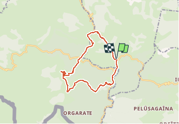
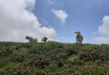
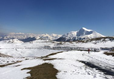
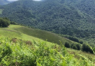
Randonnée Marche de 15 km à découvrir à Nouvelle-Aquitaine, Pyrénées-Atlantiques, Mendive. Cette randonnée est proposée par pacha56.
Description
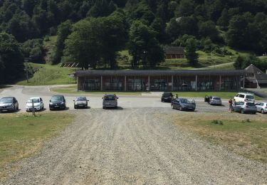
Boucle au départ du chalet d'Iraty Cize, en passant par col de Burdinkurutxeta, les crêtes du Saroberri, col de Sourzay, nécropole d'Occabe, sommet de l'Occabe et GR10 au retour
Localisation
Pays :
France
Région :
Nouvelle-Aquitaine
Département/Province :
Pyrénées-Atlantiques
Commune :
Mendive
Localité :
Unknown
Départ:(Dec)
Départ:(UTM)
656906 ; 4768009 (30T) N.
Commentaires
Randonnées à proximité
![Randonnée Marche Larrau - IRATY le pic des escaliers sans monter au pic 408M+ 2948308 - Photo](https://media.geolcdn.com/t/375/260/1725c3fb-51a3-4e7e-9d48-19cb60baeea0.jpg&format=jpg&maxdim=2)
![Marche Marche](https://static1.geolcdn.com/sitytour/trail-icons/101.png)
IRATY le pic des escaliers sans monter au pic 408M+ 2948308
Marche
Difficile
Larrau,
Nouvelle-Aquitaine,
Pyrénées-Atlantiques,
France
![](/images/other/stat-length.png)
7,9 km | 13,4 km-effort
3h 2min
![](https://static1.geolcdn.com/siteimages/upload/files/16400158638029165_repeat_loop_refresh_sync_direction_icon.png)
Oui
![Randonnée Marche Larrau - Iraty cabane ZINGOLATZE - Photo](https://media.geolcdn.com/t/375/260/44ee5c4f-fb20-4eee-9c16-d8a5e8350ada.jpg&format=jpg&maxdim=2)
![Marche Marche](https://static1.geolcdn.com/sitytour/trail-icons/101.png)
Iraty cabane ZINGOLATZE
Marche
Très facile
Larrau,
Nouvelle-Aquitaine,
Pyrénées-Atlantiques,
France
![](/images/other/stat-length.png)
6,8 km | 9,7 km-effort
3h 29min
![](https://static1.geolcdn.com/siteimages/upload/files/16400158638029165_repeat_loop_refresh_sync_direction_icon.png)
Oui
![Randonnée Marche Larrau - GR 10 T - Photo](https://media.geolcdn.com/t/375/260/5faacc01-4cf0-48af-992e-bb3842b7dc29.jpg&format=jpg&maxdim=2)
![Marche Marche](https://static1.geolcdn.com/sitytour/trail-icons/101.png)
GR 10 T
Marche
Moyen
Larrau,
Nouvelle-Aquitaine,
Pyrénées-Atlantiques,
France
![](/images/other/stat-length.png)
5,3 km | 7 km-effort
1h 40min
![](https://static1.geolcdn.com/siteimages/upload/files/16400158638029165_repeat_loop_refresh_sync_direction_icon.png)
Non
![Randonnée Marche Larrau - le Pic des Escalier - Photo](https://media.geolcdn.com/t/375/260/25a58932-02ea-4249-a083-fd59fc4e847e.jpg&format=jpg&maxdim=2)
![Marche Marche](https://static1.geolcdn.com/sitytour/trail-icons/101.png)
le Pic des Escalier
Marche
Moyen
Larrau,
Nouvelle-Aquitaine,
Pyrénées-Atlantiques,
France
![](/images/other/stat-length.png)
10,4 km | 16,7 km-effort
3h 8min
![](https://static1.geolcdn.com/siteimages/upload/files/16400158638029165_repeat_loop_refresh_sync_direction_icon.png)
Oui
![Randonnée Marche Lecumberry - Okabe magique - Photo](https://media.geolcdn.com/t/375/260/072c8693-4101-429d-bd0b-7f3d41337b96.jpg&format=jpg&maxdim=2)
![Marche Marche](https://static1.geolcdn.com/sitytour/trail-icons/101.png)
Okabe magique
Marche
Difficile
Lecumberry,
Nouvelle-Aquitaine,
Pyrénées-Atlantiques,
France
![](/images/other/stat-length.png)
15,2 km | 25 km-effort
5h 31min
![](https://static1.geolcdn.com/siteimages/upload/files/16400158638029165_repeat_loop_refresh_sync_direction_icon.png)
Oui
![Randonnée Marche Larrau - Iraty « escaliers » - Photo](https://media.geolcdn.com/t/375/260/42225316-23e6-495d-8c25-50310cc3c362.jpg&format=jpg&maxdim=2)
![Marche Marche](https://static1.geolcdn.com/sitytour/trail-icons/101.png)
Iraty « escaliers »
Marche
Facile
Larrau,
Nouvelle-Aquitaine,
Pyrénées-Atlantiques,
France
![](/images/other/stat-length.png)
19,1 km | 28 km-effort
6h 32min
![](https://static1.geolcdn.com/siteimages/upload/files/16400158638029165_repeat_loop_refresh_sync_direction_icon.png)
Non
![Randonnée Marche Lecumberry - IRATI : GOROSTIBIZKARRA 1340m - Photo](https://media.geolcdn.com/t/375/260/a59d3f76-fd9f-4aca-903e-cf76eaa1cfd9.jpg&format=jpg&maxdim=2)
![Marche Marche](https://static1.geolcdn.com/sitytour/trail-icons/101.png)
IRATI : GOROSTIBIZKARRA 1340m
Marche
Facile
Lecumberry,
Nouvelle-Aquitaine,
Pyrénées-Atlantiques,
France
![](/images/other/stat-length.png)
9,1 km | 13,9 km-effort
2h 41min
![](https://static1.geolcdn.com/siteimages/upload/files/16400158638029165_repeat_loop_refresh_sync_direction_icon.png)
Oui
![Randonnée Marche Larrau - IRATY Chapelle Notre Dame des Neiges et Casas de Irati - Photo](https://media.geolcdn.com/t/375/260/4820dd3f-a315-4e52-ac6d-42397795308f.jpg&format=jpg&maxdim=2)
![Marche Marche](https://static1.geolcdn.com/sitytour/trail-icons/101.png)
IRATY Chapelle Notre Dame des Neiges et Casas de Irati
Marche
Facile
Larrau,
Nouvelle-Aquitaine,
Pyrénées-Atlantiques,
France
![](/images/other/stat-length.png)
22 km | 33 km-effort
6h 22min
![](https://static1.geolcdn.com/siteimages/upload/files/16400158638029165_repeat_loop_refresh_sync_direction_icon.png)
Oui
![Randonnée Marche Lecumberry - IRATY PETRILARRE-HEGIXURIA en boucle - Photo](https://media.geolcdn.com/t/375/260/858f8db3-ac8d-4103-89b2-b5fb262d83c8.jpg&format=jpg&maxdim=2)
![Marche Marche](https://static1.geolcdn.com/sitytour/trail-icons/101.png)
IRATY PETRILARRE-HEGIXURIA en boucle
Marche
Moyen
Lecumberry,
Nouvelle-Aquitaine,
Pyrénées-Atlantiques,
France
![](/images/other/stat-length.png)
13,6 km | 22 km-effort
4h 29min
![](https://static1.geolcdn.com/siteimages/upload/files/16400158638029165_repeat_loop_refresh_sync_direction_icon.png)
Oui