![](/images/other/stat-length.png)
![Randonnée Marche nordique Floreffe - Soye place de l'Europe - Photo](https://media.geolcdn.com/t/1900/400/ext.pjpeg?maxdim=2&url=https%3A%2F%2Fstatic1.geolcdn.com%2Fsiteimages%2Fupload%2Ffiles%2F1545311037marcheuse_200dpi.jpg)
Soye place de l'Europe
jgo
Utilisateur
![Longueur](/images/other/stat-length.png)
Longueur
7,6 km
![Altitude max](https://static1.geolcdn.com/siteimages/upload/files/1508320355ic_sort_altitude_max_24dp.png)
Altitude max
130 m
![Dénivelé positif](https://static1.geolcdn.com/siteimages/upload/files/1508320355ic_sort_den_pos_24dp.png)
Dénivelé positif
86 m
![Km-Effort](/images/other/stat-length.png)
Km-Effort
8,7 km
![Altitude min](https://static1.geolcdn.com/siteimages/upload/files/1508320355ic_sort_altitude_min_24dp.png)
Altitude min
81 m
![Dénivelé négatif](https://static1.geolcdn.com/siteimages/upload/files/1508320355ic_sort_den_neg_24dp.png)
Dénivelé négatif
87 m
![Boucle](https://static1.geolcdn.com/siteimages/upload/files/16400158638029165_repeat_loop_refresh_sync_direction_icon.png)
Boucle
Oui
Date de création :
2021-05-19 15:39:36.362
Dernière modification :
2021-07-26 07:43:26.128
![Marche nordique](https://static1.geolcdn.com/sitytour/trail-icons/102.png)
--
Difficulté : Facile
![Scannez ce code QR pour ouvrir la randonnée dans l'application SityTrail](https://capi.geolives.com/qq0zvz2zws4bq2lad0pu/sitytour/trails/2793100/qr.png?size=200)
Application GPS de randonnée GRATUITE
À propos
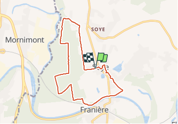
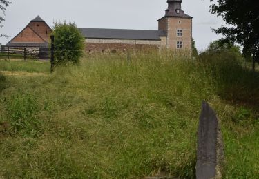
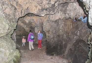
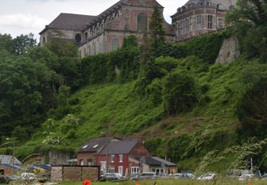
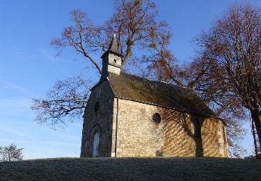
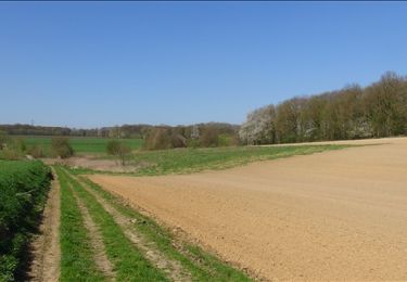
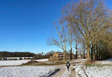
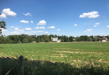
Randonnée Marche nordique de 7,6 km à découvrir à Wallonie, Namur, Floreffe. Cette randonnée est proposée par jgo.
Description
Parcours sans grande difficulté au départ de la place de l'Europe à Soye (Franière).
La plupart du temps, sur des chemins le long ou dans les bois, le long de la Sambre et en traversant une zone herbeuse.
Quelques tronçons de route peu fréquentées.
Localisation
Pays :
Belgique
Région :
Wallonie
Département/Province :
Namur
Commune :
Floreffe
Localité :
Soye
Départ:(Dec)
Départ:(UTM)
622759 ; 5589996 (31U) N.
Commentaires
Randonnées à proximité
![Marche Marche](https://static1.geolcdn.com/sitytour/trail-icons/101.png)
RB-Na-19_Floreffe
Marche
Très difficile
(20)
Floreffe,
Wallonie,
Namur,
Belgique
![](/images/other/stat-length.png)
19,9 km | 25 km-effort
5h 40min
![](https://static1.geolcdn.com/siteimages/upload/files/16400158638029165_repeat_loop_refresh_sync_direction_icon.png)
Oui
![Randonnée Marche Jemeppe-sur-Sambre - RF-Na-01-Onoz_Petite-boucle - Photo](https://media.geolcdn.com/t/375/260/ext.jpg?maxdim=2&url=https%3A%2F%2Fservices.sitytrail.com%2FGeolivesWS%2FDownloadMedia.ashx%3FTrailID%3D545735%26Media%3Df68c7b52-4432-4018-b01d-0bb04e06ad16.jpg)
![Marche Marche](https://static1.geolcdn.com/sitytour/trail-icons/101.png)
RF-Na-01-Onoz_Petite-boucle
Marche
Facile
(10)
Jemeppe-sur-Sambre,
Wallonie,
Namur,
Belgique
![](/images/other/stat-length.png)
7,4 km | 8,9 km-effort
1h 59min
![](https://static1.geolcdn.com/siteimages/upload/files/16400158638029165_repeat_loop_refresh_sync_direction_icon.png)
Oui
![Randonnée Marche Floreffe - Promenade vers Soye par bois et champs - Photo](https://media.geolcdn.com/t/375/260/ext.jpg?maxdim=2&url=https%3A%2F%2Fstatic1.geolcdn.com%2Fsiteimages%2Fupload%2Ffiles%2F1553511878bg_sport_marche.png)
![Marche Marche](https://static1.geolcdn.com/sitytour/trail-icons/101.png)
Promenade vers Soye par bois et champs
Marche
Facile
(7)
Floreffe,
Wallonie,
Namur,
Belgique
![](/images/other/stat-length.png)
12,3 km | 15,3 km-effort
3h 0min
![](https://static1.geolcdn.com/siteimages/upload/files/16400158638029165_repeat_loop_refresh_sync_direction_icon.png)
Oui
![Marche Marche](https://static1.geolcdn.com/sitytour/trail-icons/101.png)
RB-Na-19_Floreffe_via-racc
Marche
Difficile
(3)
Floreffe,
Wallonie,
Namur,
Belgique
![](/images/other/stat-length.png)
13,6 km | 17,5 km-effort
3h 58min
![](https://static1.geolcdn.com/siteimages/upload/files/16400158638029165_repeat_loop_refresh_sync_direction_icon.png)
Oui
![Randonnée Marche Floreffe - Balade à Floreffe - Photo](https://media.geolcdn.com/t/375/260/ext.jpg?maxdim=2&url=https%3A%2F%2Fservices.sitytrail.com%2FGeolivesWS%2FDownloadMedia.ashx%3FTrailID%3D236798%26Media%3Da4a2a0f8-d559-4930-aa85-d9a1040537b5.JPG)
![Marche Marche](https://static1.geolcdn.com/sitytour/trail-icons/101.png)
Balade à Floreffe
Marche
Très facile
(1)
Floreffe,
Wallonie,
Namur,
Belgique
![](/images/other/stat-length.png)
10,1 km | 14 km-effort
2h 56min
![](https://static1.geolcdn.com/siteimages/upload/files/16400158638029165_repeat_loop_refresh_sync_direction_icon.png)
Oui
![Randonnée Marche Namur - De Temploux à Suarlée - Photo](https://media.geolcdn.com/t/375/260/ext.jpg?maxdim=2&url=https%3A%2F%2Fservices.sitytrail.com%2FGeolivesWS%2FDownloadMedia.ashx%3FTrailID%3D187873%26Media%3D0f5c6b3b-618b-4553-bddc-22cf26058eb0.JPG)
![Marche Marche](https://static1.geolcdn.com/sitytour/trail-icons/101.png)
De Temploux à Suarlée
Marche
Facile
(1)
Namur,
Wallonie,
Namur,
Belgique
![](/images/other/stat-length.png)
10,7 km | 12,4 km-effort
2h 40min
![](https://static1.geolcdn.com/siteimages/upload/files/16400158638029165_repeat_loop_refresh_sync_direction_icon.png)
Oui
![Randonnée Marche Jemeppe-sur-Sambre - La petite boucle de Onoz - Photo](https://media.geolcdn.com/t/375/260/728a8926-dea5-48ea-8a91-8a3e4029625e.jpg&format=jpg&maxdim=2)
![Marche Marche](https://static1.geolcdn.com/sitytour/trail-icons/101.png)
La petite boucle de Onoz
Marche
Facile
(3)
Jemeppe-sur-Sambre,
Wallonie,
Namur,
Belgique
![](/images/other/stat-length.png)
7 km | 8,4 km-effort
1h 57min
![](https://static1.geolcdn.com/siteimages/upload/files/16400158638029165_repeat_loop_refresh_sync_direction_icon.png)
Oui
![Randonnée A pied Jemeppe-sur-Sambre - Sur les traces de l'homme de Spy à Jemeppe-sur-Sambre - Photo](https://media.geolcdn.com/t/375/260/0d4612b7-1403-4944-8642-8449664fec59.jpeg&format=jpg&maxdim=2)
![A pied A pied](https://static1.geolcdn.com/sitytour/trail-icons/100.png)
Sur les traces de l'homme de Spy à Jemeppe-sur-Sambre
A pied
Facile
(1)
Jemeppe-sur-Sambre,
Wallonie,
Namur,
Belgique
![](/images/other/stat-length.png)
3,5 km | 4,7 km-effort
1h 3min
![](https://static1.geolcdn.com/siteimages/upload/files/16400158638029165_repeat_loop_refresh_sync_direction_icon.png)
Oui
![Marche Marche](https://static1.geolcdn.com/sitytour/trail-icons/101.png)
Franiere Temploux-corona2020-20Km
Marche
Facile
(1)
Floreffe,
Wallonie,
Namur,
Belgique
![](/images/other/stat-length.png)
20 km | 24 km-effort
4h 0min
![](https://static1.geolcdn.com/siteimages/upload/files/16400158638029165_repeat_loop_refresh_sync_direction_icon.png)
Oui