![](/images/other/stat-length.png)
![Randonnée V.T.T. Embrun - Les tourniquets - Photo](https://media.geolcdn.com/t/1900/400/01b64a53-bd2c-41a4-80fe-a241ca7e9803.jpeg&format=pjpeg&maxdim=2)
Les tourniquets
xaviergilles
Utilisateur
![Longueur](/images/other/stat-length.png)
![Altitude max](https://static1.geolcdn.com/siteimages/upload/files/1508320355ic_sort_altitude_max_24dp.png)
![Dénivelé positif](https://static1.geolcdn.com/siteimages/upload/files/1508320355ic_sort_den_pos_24dp.png)
![Km-Effort](/images/other/stat-length.png)
![Altitude min](https://static1.geolcdn.com/siteimages/upload/files/1508320355ic_sort_altitude_min_24dp.png)
![Dénivelé négatif](https://static1.geolcdn.com/siteimages/upload/files/1508320355ic_sort_den_neg_24dp.png)
![Boucle](https://static1.geolcdn.com/siteimages/upload/files/16400158638029165_repeat_loop_refresh_sync_direction_icon.png)
![V.T.T.](https://static1.geolcdn.com/sitytour/trail-icons/202.png)
3h00
Difficulté : Moyen
![Vélo électrique](https://static1.geolcdn.com/sitytour/trail-icons/205.png)
1h10
Difficulté : Moyen
![Scannez ce code QR pour ouvrir la randonnée dans l'application SityTrail](https://capi.geolives.com/qq0zvz2zws4bq2lad0pu/sitytour/trails/2792595/qr.png?size=200)
Application GPS de randonnée GRATUITE
À propos
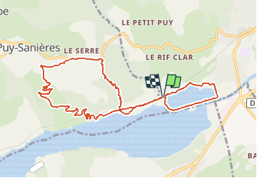
Randonnée V.T.T. de 11,3 km à découvrir à Provence-Alpes-Côte d'Azur, Hautes-Alpes, Embrun. Cette randonnée est proposée par xaviergilles.
Description
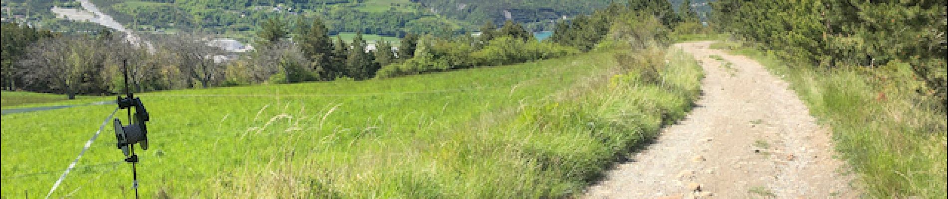
Le fameux sentier des tourniquets depuis Chadenas. Monter par la piste des Puy. Un petit bout de route avant de prendre le sentier des tourniquets. On termine avec le tour du plan d’eau. À faire en période sèche, sinon le sentier est un ruisseau. Montée sans difficulté, descente assez technique mais très ludique.
Localisation
Commentaires
Randonnées à proximité
![Randonnée Marche Embrun - Lac de l'Hivernet - Photo](https://media.geolcdn.com/t/375/260/ext.jpg?maxdim=2&url=https%3A%2F%2Fservices.sitytrail.com%2FGeolivesWS%2FDownloadMedia.ashx%3FTrailID%3D1027861%26Media%3Dfix__20180818122123.jpg)
![Marche Marche](https://static1.geolcdn.com/sitytour/trail-icons/101.png)
Marche
![](/images/other/stat-length.png)
![](https://static1.geolcdn.com/siteimages/upload/files/16400158638029165_repeat_loop_refresh_sync_direction_icon.png)
![Randonnée Marche Embrun - Mont Guillaume-Col de Chanté Perdrix-Lac de l'Hivernet(07-09-16) - Photo](https://media.geolcdn.com/t/375/260/ext.jpg?maxdim=2&url=https%3A%2F%2Fservices.sitytrail.com%2FGeolivesWS%2FDownloadMedia.ashx%3FTrailID%3D594349%26Media%3Dfix__20160707110131.jpg)
![Marche Marche](https://static1.geolcdn.com/sitytour/trail-icons/101.png)
Marche
![](/images/other/stat-length.png)
![](https://static1.geolcdn.com/siteimages/upload/files/16400158638029165_repeat_loop_refresh_sync_direction_icon.png)
![Randonnée Marche Puy-Saint-Eusèbe - canal de reyssas jusqu'aux Touisses / retour par le GR Serre-Ponçon via ravin de la pisse - Photo](https://media.geolcdn.com/t/375/260/207bcfa3-5f2f-4889-95d2-ad39c84c3a40.jpg&format=jpg&maxdim=2)
![Marche Marche](https://static1.geolcdn.com/sitytour/trail-icons/101.png)
Marche
![](/images/other/stat-length.png)
![](https://static1.geolcdn.com/siteimages/upload/files/16400158638029165_repeat_loop_refresh_sync_direction_icon.png)
![Randonnée Marche Embrun - Mont Guillaume - Col de Trempa-Latz - 2671 - Photo](https://media.geolcdn.com/t/375/260/a1ad9c13-09fc-4e7a-a956-c96541f21c7a.jpg&format=jpg&maxdim=2)
![Marche Marche](https://static1.geolcdn.com/sitytour/trail-icons/101.png)
Marche
![](/images/other/stat-length.png)
![](https://static1.geolcdn.com/siteimages/upload/files/16400158638029165_repeat_loop_refresh_sync_direction_icon.png)
![Randonnée Marche Embrun - Mont Guillaume - Photo](https://media.geolcdn.com/t/375/260/8a5a6651-8a6c-4528-b5ff-78962c8c835d.jpg&format=jpg&maxdim=2)
![Marche Marche](https://static1.geolcdn.com/sitytour/trail-icons/101.png)
Marche
![](/images/other/stat-length.png)
![](https://static1.geolcdn.com/siteimages/upload/files/16400158638029165_repeat_loop_refresh_sync_direction_icon.png)
![Randonnée Marche Embrun - Mt Guillaume - Lac de l'Hivernet - Photo](https://media.geolcdn.com/t/375/260/cbed6be4-74aa-4976-902e-a579816616cf.jpg&format=jpg&maxdim=2)
![Marche Marche](https://static1.geolcdn.com/sitytour/trail-icons/101.png)
Marche
![](/images/other/stat-length.png)
![](https://static1.geolcdn.com/siteimages/upload/files/16400158638029165_repeat_loop_refresh_sync_direction_icon.png)
![Randonnée Marche Embrun - lac de l hivernet - Photo](https://media.geolcdn.com/t/375/260/544b0507-fa9b-4776-945d-9f01d5a68a38.jpg&format=jpg&maxdim=2)
![Marche Marche](https://static1.geolcdn.com/sitytour/trail-icons/101.png)
Marche
![](/images/other/stat-length.png)
![](https://static1.geolcdn.com/siteimages/upload/files/16400158638029165_repeat_loop_refresh_sync_direction_icon.png)
![Randonnée Marche Embrun - Embrun - 3.1km 70m 1h15 - 2018 06 26 - Photo](https://media.geolcdn.com/t/375/260/ext.jpg?maxdim=2&url=https%3A%2F%2Fservices.sitytrail.com%2FGeolivesWS%2FDownloadMedia.ashx%3FTrailID%3D999315%26Media%3Dfix__20180626102346.jpg)
![Marche Marche](https://static1.geolcdn.com/sitytour/trail-icons/101.png)
Marche
![](/images/other/stat-length.png)
![](https://static1.geolcdn.com/siteimages/upload/files/16400158638029165_repeat_loop_refresh_sync_direction_icon.png)
![Randonnée Marche Embrun - embrun - Photo](https://media.geolcdn.com/t/375/260/983747e0-b406-4f08-9e49-4a70208cddfc.jpg&format=jpg&maxdim=2)
![Marche Marche](https://static1.geolcdn.com/sitytour/trail-icons/101.png)
Marche
![](/images/other/stat-length.png)
![](https://static1.geolcdn.com/siteimages/upload/files/16400158638029165_repeat_loop_refresh_sync_direction_icon.png)
Très sympas pour recommencer après une longue période d’arrêt. Il donne envie de refaire plus