![](/images/other/stat-length.png)
![Randonnée A pied Soignies - Casteau, Saint Denis et Gottignies en longeant l'Aubrecheuil et la Wanze - Photo](https://media.geolcdn.com/t/1900/400/ext.pjpeg?maxdim=2&url=https%3A%2F%2Fstatic1.geolcdn.com%2Fsiteimages%2Fupload%2Ffiles%2F1545311037marcheuse_200dpi.jpg)
Casteau, Saint Denis et Gottignies en longeant l'Aubrecheuil et la Wanze
Limce
Utilisateur
![Longueur](/images/other/stat-length.png)
Longueur
21 km
![Altitude max](https://static1.geolcdn.com/siteimages/upload/files/1508320355ic_sort_altitude_max_24dp.png)
Altitude max
118 m
![Dénivelé positif](https://static1.geolcdn.com/siteimages/upload/files/1508320355ic_sort_den_pos_24dp.png)
Dénivelé positif
260 m
![Km-Effort](/images/other/stat-length.png)
Km-Effort
24 km
![Altitude min](https://static1.geolcdn.com/siteimages/upload/files/1508320355ic_sort_altitude_min_24dp.png)
Altitude min
51 m
![Dénivelé négatif](https://static1.geolcdn.com/siteimages/upload/files/1508320355ic_sort_den_neg_24dp.png)
Dénivelé négatif
260 m
![Boucle](https://static1.geolcdn.com/siteimages/upload/files/16400158638029165_repeat_loop_refresh_sync_direction_icon.png)
Boucle
Oui
Date de création :
2021-05-17 22:30:40.647
Dernière modification :
2022-01-11 22:53:28.666
![A pied](https://static1.geolcdn.com/sitytour/trail-icons/100.png)
5h28
Difficulté : Moyen
![Scannez ce code QR pour ouvrir la randonnée dans l'application SityTrail](https://capi.geolives.com/qq0zvz2zws4bq2lad0pu/sitytour/trails/2791067/qr.png?size=200)
Application GPS de randonnée GRATUITE
À propos
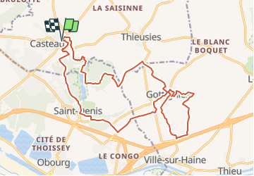
Randonnée A pied de 21 km à découvrir à Wallonie, Hainaut, Soignies. Cette randonnée est proposée par Limce.
Description
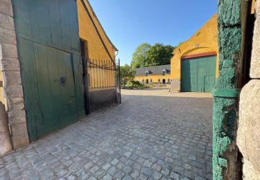
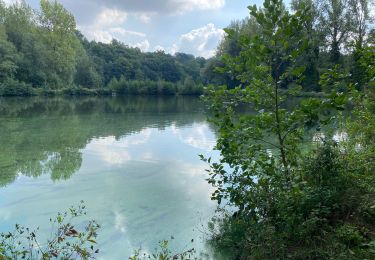
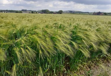
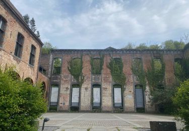
Randonnée bucolique de 21 km au départ de Casteau. Nous longeons l'Aubrecheuil pour nous diriger vers les étangs de Saint-Denis puis, nous nous laissons guider par la Wanze à Gottignies surnommée la Petite Suisse rhodienne.
Localisation
Pays :
Belgique
Région :
Wallonie
Département/Province :
Hainaut
Commune :
Soignies
Localité :
Unknown
Départ:(Dec)
Départ:(UTM)
571632 ; 5596232 (31U) N.
Commentaires
Randonnées à proximité
![Randonnée Marche Mons - De Saint-Denis à Casteau par la vallée de l'Obrecheuil - Photo](https://media.geolcdn.com/t/375/260/ext.jpg?maxdim=2&url=https%3A%2F%2Fstatic1.geolcdn.com%2Fsiteimages%2Fupload%2Ffiles%2F1553511878bg_sport_marche.png)
![Marche Marche](https://static1.geolcdn.com/sitytour/trail-icons/101.png)
De Saint-Denis à Casteau par la vallée de l'Obrecheuil
Marche
Facile
(4)
Mons,
Wallonie,
Hainaut,
Belgique
![](/images/other/stat-length.png)
8,2 km | 9,9 km-effort
2h 0min
![](https://static1.geolcdn.com/siteimages/upload/files/16400158638029165_repeat_loop_refresh_sync_direction_icon.png)
Oui
![Randonnée Marche Mons - Marche Adeps à Saint Denis - Photo](https://media.geolcdn.com/t/375/260/02b5f8c2-2d7c-496a-8034-c64ce2a8504a.jpeg&format=jpg&maxdim=2)
![Marche Marche](https://static1.geolcdn.com/sitytour/trail-icons/101.png)
Marche Adeps à Saint Denis
Marche
Moyen
Mons,
Wallonie,
Hainaut,
Belgique
![](/images/other/stat-length.png)
8,9 km | 10,8 km-effort
2h 27min
![](https://static1.geolcdn.com/siteimages/upload/files/16400158638029165_repeat_loop_refresh_sync_direction_icon.png)
Oui
![Randonnée Marche Mons - Saint Denis 16,5 km - Photo](https://media.geolcdn.com/t/375/260/16f1150e-75c0-4278-be2e-034c504c0601.jpg&format=jpg&maxdim=2)
![Marche Marche](https://static1.geolcdn.com/sitytour/trail-icons/101.png)
Saint Denis 16,5 km
Marche
Moyen
Mons,
Wallonie,
Hainaut,
Belgique
![](/images/other/stat-length.png)
16,7 km | 19,1 km-effort
4h 43min
![](https://static1.geolcdn.com/siteimages/upload/files/16400158638029165_repeat_loop_refresh_sync_direction_icon.png)
Oui
![Randonnée Marche Mons - SAINT-DENIS/OBOURG _ Marche Adeps _ HT _ 25/06/2023. - Photo](https://media.geolcdn.com/t/375/260/5eb01db4-598a-4a9d-8738-bf9405385586.jpg&format=jpg&maxdim=2)
![Marche Marche](https://static1.geolcdn.com/sitytour/trail-icons/101.png)
SAINT-DENIS/OBOURG _ Marche Adeps _ HT _ 25/06/2023.
Marche
Moyen
Mons,
Wallonie,
Hainaut,
Belgique
![](/images/other/stat-length.png)
19 km | 22 km-effort
4h 21min
![](https://static1.geolcdn.com/siteimages/upload/files/16400158638029165_repeat_loop_refresh_sync_direction_icon.png)
Oui
![Randonnée Marche Soignies - Thieusies Rando des châteaux et moulins - Photo](https://media.geolcdn.com/t/375/260/2ecbf931-c0d5-4b39-b269-acf7cba38718.jpg&format=jpg&maxdim=2)
![Marche Marche](https://static1.geolcdn.com/sitytour/trail-icons/101.png)
Thieusies Rando des châteaux et moulins
Marche
Facile
Soignies,
Wallonie,
Hainaut,
Belgique
![](/images/other/stat-length.png)
8,8 km | 9,9 km-effort
2h 9min
![](https://static1.geolcdn.com/siteimages/upload/files/16400158638029165_repeat_loop_refresh_sync_direction_icon.png)
Oui
![Randonnée Marche Mons - Saint Denis 13,5 km - Photo](https://media.geolcdn.com/t/375/260/eaa6e251-168c-4594-8dce-334e3eb917f9.jpg&format=jpg&maxdim=2)
![Marche Marche](https://static1.geolcdn.com/sitytour/trail-icons/101.png)
Saint Denis 13,5 km
Marche
Facile
(1)
Mons,
Wallonie,
Hainaut,
Belgique
![](/images/other/stat-length.png)
13,6 km | 15,7 km-effort
4h 4min
![](https://static1.geolcdn.com/siteimages/upload/files/16400158638029165_repeat_loop_refresh_sync_direction_icon.png)
Oui
![Randonnée Marche Soignies - Autour du Grand Pont - Photo](https://media.geolcdn.com/t/375/260/0e9b2b89-cfcc-4492-b4cb-7034c330aa56.jpg&format=jpg&maxdim=2)
![Marche Marche](https://static1.geolcdn.com/sitytour/trail-icons/101.png)
Autour du Grand Pont
Marche
Moyen
Soignies,
Wallonie,
Hainaut,
Belgique
![](/images/other/stat-length.png)
5,9 km | 6,3 km-effort
1h 26min
![](https://static1.geolcdn.com/siteimages/upload/files/16400158638029165_repeat_loop_refresh_sync_direction_icon.png)
Oui
![Randonnée Marche Mons - Abbaye de Saint-Denis et son vignoble (ADEPS) - Photo](https://media.geolcdn.com/t/375/260/6c183451-68f5-4293-8ad4-44087b07b24b.jpeg&format=jpg&maxdim=2)
![Marche Marche](https://static1.geolcdn.com/sitytour/trail-icons/101.png)
Abbaye de Saint-Denis et son vignoble (ADEPS)
Marche
Facile
Mons,
Wallonie,
Hainaut,
Belgique
![](/images/other/stat-length.png)
15,6 km | 18,1 km-effort
3h 24min
![](https://static1.geolcdn.com/siteimages/upload/files/16400158638029165_repeat_loop_refresh_sync_direction_icon.png)
Oui
![Randonnée Marche Mons - Saint-Denis - Photo](https://media.geolcdn.com/t/375/260/31e04365-1ada-45fc-ab6e-548ae017019f.jpg&format=jpg&maxdim=2)
![Marche Marche](https://static1.geolcdn.com/sitytour/trail-icons/101.png)
Saint-Denis
Marche
Très facile
Mons,
Wallonie,
Hainaut,
Belgique
![](/images/other/stat-length.png)
6,6 km | 8,1 km-effort
1h 32min
![](https://static1.geolcdn.com/siteimages/upload/files/16400158638029165_repeat_loop_refresh_sync_direction_icon.png)
Oui