Randonnée Marche Saint-Saturnin-de-Lucian - rocher vierge et canyon du diable - Photo

rocher vierge et canyon du diable

 gadafo
gadafo

Utilisateur

© OpenStreetMap contributors
Longueur
Longueur
13,1 km
Altitude max
Altitude max
521 m
Dénivelé positif
Dénivelé positif
594 m
Km-Effort
Km-Effort  
21 km
Altitude min
Altitude min
120 m
Dénivelé négatif
Dénivelé négatif
598 m
Boucle
Boucle
Oui
Date de création :
2021-05-17 11:54:09.592
Dernière modification :
2021-05-17 11:56:22.867

(0 Avis)

Marche
Marche
4h46
Difficulté : Moyen

Scannez ce code QR pour ouvrir la randonnée dans l'application SityTrail

Application GPS de randonnée GRATUITE

Logo SityTrail SityTrail

IGN / Instituts géographiques

Télécharger SityTrail sur l'App Store Télécharger SityTrail sur Google Play

Logo SityTrail SityTrail World

Le monde est à vous

Télécharger SityTrail sur l'App Store Télécharger SityTrail sur Google Play Télécharger SityTrail sur Huawei AppGallery

À propos

Randonnée Marche de 13,1 km à découvrir à Occitanie, Hérault, Saint-Saturnin-de-Lucian. Cette randonnée est proposée par gadafo.

Profil altimétrique

Localisation

Pays :
France
Région :
Occitanie
Département/Province :
Hérault
Commune :
Saint-Saturnin-de-Lucian
Localité :
Unknown
Départ:(Dec)
Départ:(UTM)
537590 ; 4837849 (31T) N.

Randonnées à proximité

Randonnée Marche Saint-Saturnin-de-Lucian - Le Rocher des vierges - Photo
Marche
daniel34

Marche

Moyen
(2)
Saint-Saturnin-de-Lucian, Occitanie, Hérault, France
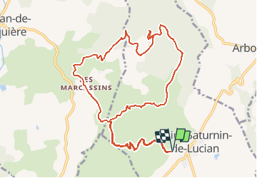
12,1 km | 17,4 km-effort
5h 1min
Oui
Randonnée Marche Lacoste - lacoste vers le lac - Photo
Marche
kiki34

Marche

Moyen
(2)
Lacoste, Occitanie, Hérault, France
12,2 km | 15,4 km-effort
3h 11min
Oui
Randonnée Marche Montpeyroux - château de castelas - Photo
Marche
mrclic34

Marche

Facile
(3)
Montpeyroux, Occitanie, Hérault, France
10,3 km | 15,1 km-effort
3h 12min
Oui
Randonnée Marche Montpeyroux - Saint baudille - Photo
Marche
yt34

Marche

Facile
(3)
Montpeyroux, Occitanie, Hérault, France
10,2 km | 16,2 km-effort
3h 22min
Oui
Randonnée Marche Saint-Jean-de-la-Blaquière - Les Bois de Homs et de Latude - Photo
Marche
gerardhenr

Marche

Facile
(1)
Saint-Jean-de-la-Blaquière, Occitanie, Hérault, France
9,3 km | 13,1 km-effort
2h 27min
Oui
Randonnée Marche Montpeyroux - Font du Griffe le Baudille - Photo
Marche
daniel34

Marche

Difficile
Montpeyroux, Occitanie, Hérault, France
10,8 km | 16,8 km-effort
3h 32min
Oui
Randonnée Marche Montpeyroux - Le bary Arboras le Castelas - Photo
Marche
labarone

Marche

Facile
Montpeyroux, Occitanie, Hérault, France
11,8 km | 17,1 km-effort
5h 7min
Oui
Randonnée Marche Montpeyroux - tour : font du griffe et mont St Baudille - Photo
Marche
jeanfcd

Marche

Difficile
Montpeyroux, Occitanie, Hérault, France
11,5 km | 17,5 km-effort
3h 58min
Oui
Randonnée Marche Montpeyroux - Le Castellas de Montpeyroux - Photo
Marche
Indi34

Marche

Moyen
Montpeyroux, Occitanie, Hérault, France
6,6 km | 9,5 km-effort
2h 2min
Oui


Fermer
Mes abonnements