Randonnée V.T.C. Poperinge - Toer in de Westhoek  - Photo
 bometdehamer
bometdehamer

Utilisateur

© OpenStreetMap contributors
Longueur
Longueur
90 km
Altitude max
Altitude max
56 m
Dénivelé positif
Dénivelé positif
396 m
Km-Effort
Km-Effort  
95 km
Altitude min
Altitude min
-3 m
Dénivelé négatif
Dénivelé négatif
395 m
Boucle
Boucle
Oui
Date de création :
2021-05-16 08:10:40.0
Dernière modification :
2021-05-17 05:52:05.637

(0 Avis)

V.T.C.
V.T.C.
7h42
Difficulté :

Scannez ce code QR pour ouvrir la randonnée dans l'application SityTrail

Application GPS de randonnée GRATUITE

Logo SityTrail SityTrail

IGN / Instituts géographiques

Télécharger SityTrail sur l'App Store Télécharger SityTrail sur Google Play

Logo SityTrail SityTrail World

Le monde est à vous

Télécharger SityTrail sur l'App Store Télécharger SityTrail sur Google Play Télécharger SityTrail sur Huawei AppGallery

À propos

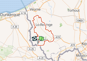
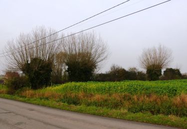
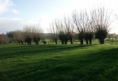
Randonnée V.T.C. de 90 km à découvrir à Flandre, Flandre-Occidentale, Poperinge. Cette randonnée est proposée par bometdehamer.

Description

Mooie tocht langs kleine dorpen, langs Lovaart en kanaal Ieper-IJzer

Profil altimétrique

Localisation

Pays :
Belgique
Région :
Flandre
Département/Province :
Flandre-Occidentale
Commune :
Poperinge
Localité :
Poperinge
Départ:(Dec)
Départ:(UTM)
478755 ; 5630364 (31U) N.

Randonnées à proximité

Randonnée Marche Berthen - Autour du monastère - Godewaersvelde - Photo
Marche
tracegps

Marche

Difficile
(3)
Berthen, Hauts-de-France, Nord, France
11,8 km | 15,6 km-effort
3h 0min
Oui
Randonnée Marche Heuvelland - Loker - Le Mont Rouge - Photo
Marche
tracegps

Marche

Moyen
(3)
Heuvelland, Flandre, Flandre-Occidentale, Belgique
8,7 km | 10,8 km-effort
2h 19min
Oui
Randonnée A pied Heuvelland - Tweebergen wandelroute - Photo
A pied
GUIDE+

A pied

Facile
Heuvelland, Flandre, Flandre-Occidentale, Belgique
7,3 km | 9 km-effort
2h 2min
Oui
Randonnée Marche Heuvelland - Westouter langs tweetermen - Photo
Marche
Wesley Samyn

Marche

Difficile
(1)
Heuvelland, Flandre, Flandre-Occidentale, Belgique
7,5 km | 9,1 km-effort
2h 4min
Oui
Randonnée Marche Saint-Jans-Cappel - sentier des jacynthes - Photo
Marche
Bernard.voyageur

Marche

Moyen
(1)
Saint-Jans-Cappel, Hauts-de-France, Nord, France
7,3 km | 9,2 km-effort
2h 1min
Oui
Randonnée Marche Heuvelland - Monts Rouge et Noir - Photo
Marche
Greg813

Marche

Difficile
Heuvelland, Flandre, Flandre-Occidentale, Belgique
24 km | 30 km-effort
5h 27min
Oui
Randonnée Marche Boeschepe - Boeschepe - Photo
Marche
fif59280

Marche

Difficile
Boeschepe, Hauts-de-France, Nord, France
10,6 km | 13 km-effort
2h 26min
Non
Randonnée A pied Poperinge - Helleketelbos - Photo
A pied
GUIDE+

A pied

Facile
Poperinge, Flandre, Flandre-Occidentale, Belgique
10,8 km | 12,5 km-effort
2h 49min
Oui
Randonnée A pied Poperinge - Zevekotepad Reningelst - Photo
A pied
GUIDE+

A pied

Facile
Poperinge, Flandre, Flandre-Occidentale, Belgique
6,9 km | 7,9 km-effort
1h 47min
Oui


Fermer
Mes abonnements