![](/images/other/stat-length.png)
![Randonnée Marche Braine-le-Château - Braine-le-Château _ GR _ BW _ RB 14 - Photo](https://media.geolcdn.com/t/1900/400/ce6588ad-fe0c-4531-a595-1080080684d5.jpg&format=pjpeg&maxdim=2)
Braine-le-Château _ GR _ BW _ RB 14
jeangulu
Utilisateur
![Longueur](/images/other/stat-length.png)
Longueur
23 km
![Altitude max](https://static1.geolcdn.com/siteimages/upload/files/1508320355ic_sort_altitude_max_24dp.png)
Altitude max
132 m
![Dénivelé positif](https://static1.geolcdn.com/siteimages/upload/files/1508320355ic_sort_den_pos_24dp.png)
Dénivelé positif
449 m
![Km-Effort](/images/other/stat-length.png)
Km-Effort
29 km
![Altitude min](https://static1.geolcdn.com/siteimages/upload/files/1508320355ic_sort_altitude_min_24dp.png)
Altitude min
36 m
![Dénivelé négatif](https://static1.geolcdn.com/siteimages/upload/files/1508320355ic_sort_den_neg_24dp.png)
Dénivelé négatif
449 m
![Boucle](https://static1.geolcdn.com/siteimages/upload/files/16400158638029165_repeat_loop_refresh_sync_direction_icon.png)
Boucle
Oui
Date de création :
2021-05-16 09:47:18.899
Dernière modification :
2021-05-17 08:09:05.6
![Marche](https://static1.geolcdn.com/sitytour/trail-icons/101.png)
6h14
Difficulté : Moyen
![Scannez ce code QR pour ouvrir la randonnée dans l'application SityTrail](https://capi.geolives.com/qq0zvz2zws4bq2lad0pu/sitytour/trails/2789416/qr.png?size=200)
Application GPS de randonnée GRATUITE
À propos
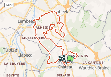
Randonnée Marche de 23 km à découvrir à Wallonie, Brabant wallon, Braine-le-Château. Cette randonnée est proposée par jeangulu.
Description
Point de départ : Parking de la grand-place de Braine - le - Château.
Au nord de Braine - le -Château, à travers de petites réserves naturelles
{ Braine-le-Château - Lembeek - Essenbeek - Braine-le-Château )
Localisation
Pays :
Belgique
Région :
Wallonie
Département/Province :
Brabant wallon
Commune :
Braine-le-Château
Localité :
Braine-le-Château
Départ:(Dec)
Départ:(UTM)
589531 ; 5615242 (31U) N.
Commentaires
Randonnées à proximité
![Randonnée Marche Braine-le-Château - RB-Bw-14_Braine-le-Château_via-racc-2 - Photo](https://media.geolcdn.com/t/375/260/ext.jpg?maxdim=2&url=https%3A%2F%2Fservices.sitytrail.com%2FGeolivesWS%2FDownloadMedia.ashx%3FTrailID%3D221634%26Media%3Deb6776bf-15f0-4f01-a140-384d1e40ee1c.jpg)
![Marche Marche](https://static1.geolcdn.com/sitytour/trail-icons/101.png)
RB-Bw-14_Braine-le-Château_via-racc-2
Marche
Très difficile
(7)
Braine-le-Château,
Wallonie,
Brabant wallon,
Belgique
![](/images/other/stat-length.png)
17,1 km | 22 km-effort
4h 56min
![](https://static1.geolcdn.com/siteimages/upload/files/16400158638029165_repeat_loop_refresh_sync_direction_icon.png)
Oui
![Randonnée Marche Braine-le-Château - RB-Bw-14_Braine-le-Château - Photo](https://media.geolcdn.com/t/375/260/ext.jpg?maxdim=2&url=https%3A%2F%2Fservices.sitytrail.com%2FGeolivesWS%2FDownloadMedia.ashx%3FTrailID%3D179589%26Media%3D13780112-341f-4401-b493-338d7230657e.jpg)
![Marche Marche](https://static1.geolcdn.com/sitytour/trail-icons/101.png)
RB-Bw-14_Braine-le-Château
Marche
Très difficile
(7)
Braine-le-Château,
Wallonie,
Brabant wallon,
Belgique
![](/images/other/stat-length.png)
23 km | 29 km-effort
6h 30min
![](https://static1.geolcdn.com/siteimages/upload/files/16400158638029165_repeat_loop_refresh_sync_direction_icon.png)
Oui
![Randonnée Marche Braine-le-Château - RB-Bw-14_Braine-le-Château_via-racc-1 - Photo](https://media.geolcdn.com/t/375/260/ext.jpg?maxdim=2&url=https%3A%2F%2Fstatic1.geolcdn.com%2Fsiteimages%2Fupload%2Ffiles%2F1553511878bg_sport_marche.png)
![Marche Marche](https://static1.geolcdn.com/sitytour/trail-icons/101.png)
RB-Bw-14_Braine-le-Château_via-racc-1
Marche
Difficile
(12)
Braine-le-Château,
Wallonie,
Brabant wallon,
Belgique
![](/images/other/stat-length.png)
11,2 km | 14,9 km-effort
3h 22min
![](https://static1.geolcdn.com/siteimages/upload/files/16400158638029165_repeat_loop_refresh_sync_direction_icon.png)
Oui
![Randonnée Marche Braine-le-Château - Marche Adeps á Braine-le-Château - Photo](https://media.geolcdn.com/t/375/260/dd34770a-5ca3-45b4-9e04-c11066a91570.jpg&format=jpg&maxdim=2)
![Marche Marche](https://static1.geolcdn.com/sitytour/trail-icons/101.png)
Marche Adeps á Braine-le-Château
Marche
Très facile
(1)
Braine-le-Château,
Wallonie,
Brabant wallon,
Belgique
![](/images/other/stat-length.png)
10,5 km | 13,7 km-effort
3h 6min
![](https://static1.geolcdn.com/siteimages/upload/files/16400158638029165_repeat_loop_refresh_sync_direction_icon.png)
Oui
![Randonnée Marche Braine-le-Château - Balade à Braine-le-Château - Photo](https://media.geolcdn.com/t/375/260/ext.jpg?maxdim=2&url=https%3A%2F%2Fservices.sitytrail.com%2FGeolivesWS%2FDownloadMedia.ashx%3FTrailID%3D566873%26Media%3Da3e1e9d2-1e6f-4d9d-bc93-2d87d42c6412.JPG)
![Marche Marche](https://static1.geolcdn.com/sitytour/trail-icons/101.png)
Balade à Braine-le-Château
Marche
Facile
(3)
Braine-le-Château,
Wallonie,
Brabant wallon,
Belgique
![](/images/other/stat-length.png)
10,8 km | 13,7 km-effort
3h 0min
![](https://static1.geolcdn.com/siteimages/upload/files/16400158638029165_repeat_loop_refresh_sync_direction_icon.png)
Oui
![Randonnée Marche Hal - Balade dans le Bois de Halle - Photo](https://media.geolcdn.com/t/375/260/ext.jpg?maxdim=2&url=https%3A%2F%2Fservices.sitytrail.com%2FGeolivesWS%2FDownloadMedia.ashx%3FTrailID%3D411974%26Media%3D4cfcce27-edaf-4211-9dbe-1277fff36f47.JPG)
![Marche Marche](https://static1.geolcdn.com/sitytour/trail-icons/101.png)
Balade dans le Bois de Halle
Marche
Facile
(2)
Hal,
Flandre,
Brabant flamand,
Belgique
![](/images/other/stat-length.png)
8,6 km | 10,5 km-effort
2h 14min
![](https://static1.geolcdn.com/siteimages/upload/files/16400158638029165_repeat_loop_refresh_sync_direction_icon.png)
Oui
![Marche Marche](https://static1.geolcdn.com/sitytour/trail-icons/101.png)
#230717 - Virginal-Samme, Ardennes et Grand Bois, dont 2,5 km du GRP 127
Marche
Moyen
(1)
Ittre,
Wallonie,
Brabant wallon,
Belgique
![](/images/other/stat-length.png)
5,1 km | 6,4 km-effort
1h 27min
![](https://static1.geolcdn.com/siteimages/upload/files/16400158638029165_repeat_loop_refresh_sync_direction_icon.png)
Oui
![Marche Marche](https://static1.geolcdn.com/sitytour/trail-icons/101.png)
#221031 - Virginal-Samme > Canal, dont 4 km sur GRP127***
Marche
Moyen
(1)
Ittre,
Wallonie,
Brabant wallon,
Belgique
![](/images/other/stat-length.png)
8,2 km | 9,9 km-effort
2h 15min
![](https://static1.geolcdn.com/siteimages/upload/files/16400158638029165_repeat_loop_refresh_sync_direction_icon.png)
Oui
![Marche Marche](https://static1.geolcdn.com/sitytour/trail-icons/101.png)
#201214 - Braine-le-Château, Les Monts, Les Fonds et Bruyère Landuyt
Marche
Moyen
(1)
Braine-le-Château,
Wallonie,
Brabant wallon,
Belgique
![](/images/other/stat-length.png)
7,8 km | 10,2 km-effort
2h 11min
![](https://static1.geolcdn.com/siteimages/upload/files/16400158638029165_repeat_loop_refresh_sync_direction_icon.png)
Oui