![](/images/other/stat-length.png)
![Randonnée Marche Villefranche-de-Conflent - boucle des chapelles Romanes de Bell Lloc - Photo](https://media.geolcdn.com/t/1900/400/e837294c-fc1b-4cdd-b4fc-dcd4d671f082.jpg&format=pjpeg&maxdim=2)
boucle des chapelles Romanes de Bell Lloc
PVERTICAL
Utilisateur
![Longueur](/images/other/stat-length.png)
Longueur
14 km
![Altitude max](https://static1.geolcdn.com/siteimages/upload/files/1508320355ic_sort_altitude_max_24dp.png)
Altitude max
1100 m
![Dénivelé positif](https://static1.geolcdn.com/siteimages/upload/files/1508320355ic_sort_den_pos_24dp.png)
Dénivelé positif
1022 m
![Km-Effort](/images/other/stat-length.png)
Km-Effort
27 km
![Altitude min](https://static1.geolcdn.com/siteimages/upload/files/1508320355ic_sort_altitude_min_24dp.png)
Altitude min
434 m
![Dénivelé négatif](https://static1.geolcdn.com/siteimages/upload/files/1508320355ic_sort_den_neg_24dp.png)
Dénivelé négatif
922 m
![Boucle](https://static1.geolcdn.com/siteimages/upload/files/16400158638029165_repeat_loop_refresh_sync_direction_icon.png)
Boucle
Non
Date de création :
2021-05-13 12:21:06.699
Dernière modification :
2021-05-13 18:32:20.976
![Marche](https://static1.geolcdn.com/sitytour/trail-icons/101.png)
3h50
Difficulté : Moyen
![Scannez ce code QR pour ouvrir la randonnée dans l'application SityTrail](https://capi.geolives.com/qq0zvz2zws4bq2lad0pu/sitytour/trails/2785443/qr.png?size=200)
Application GPS de randonnée GRATUITE
À propos
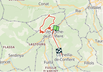
Randonnée Marche de 14 km à découvrir à Occitanie, Pyrénées-Orientales, Villefranche-de-Conflent. Cette randonnée est proposée par PVERTICAL.
Description
depuis le village fortifié de Villefranche de Conflent via le Fort Liberia, magnifique boucle en balcon au dessus de la rivière Têt. superbe vue sur Canigou et la côte. Attention, pas de point d'eau sur le sentier.
Localisation
Pays :
France
Région :
Occitanie
Département/Province :
Pyrénées-Orientales
Commune :
Villefranche-de-Conflent
Localité :
Unknown
Départ:(Dec)
Départ:(UTM)
447973 ; 4715085 (31T) N.
Commentaires
Randonnées à proximité
![Randonnée Marche Ria-Sirach - Sirach-Taurinya-Saint Michel de Cuxa - Photo](https://media.geolcdn.com/t/375/260/ext.jpg?maxdim=2&url=https%3A%2F%2Fservices.sitytrail.com%2FGeolivesWS%2FDownloadMedia.ashx%3FTrailID%3D631724%26Media%3D20160916113736.jpg)
![Marche Marche](https://static1.geolcdn.com/sitytour/trail-icons/101.png)
Sirach-Taurinya-Saint Michel de Cuxa
Marche
Facile
(2)
Ria-Sirach,
Occitanie,
Pyrénées-Orientales,
France
![](/images/other/stat-length.png)
13,5 km | 17,2 km-effort
2h 31min
![](https://static1.geolcdn.com/siteimages/upload/files/16400158638029165_repeat_loop_refresh_sync_direction_icon.png)
Oui
![Randonnée Moteur Codalet - Prades - Villefranche de Conflent - Evol - Photo](https://media.geolcdn.com/t/375/260/ext.jpg?maxdim=2&url=https%3A%2F%2Fservices.sitytrail.com%2FGeolivesWS%2FDownloadMedia.ashx%3FTrailID%3D554984%26Media%3D20160417170544.jpg)
![Moteur Moteur](https://static1.geolcdn.com/sitytour/trail-icons/400.png)
Prades - Villefranche de Conflent - Evol
Moteur
Facile
(1)
Codalet,
Occitanie,
Pyrénées-Orientales,
France
![](/images/other/stat-length.png)
36 km | 48 km-effort
3h 47min
![](https://static1.geolcdn.com/siteimages/upload/files/16400158638029165_repeat_loop_refresh_sync_direction_icon.png)
Non
![Randonnée Marche Vernet-les-Bains - La tour de Goa - Photo](https://media.geolcdn.com/t/375/260/ext.jpg?maxdim=2&url=https%3A%2F%2Fservices.sitytrail.com%2FGeolivesWS%2FDownloadMedia.ashx%3FTrailID%3D109701%26Media%3D4392_3.jpg)
![Marche Marche](https://static1.geolcdn.com/sitytour/trail-icons/101.png)
La tour de Goa
Marche
Difficile
(2)
Vernet-les-Bains,
Occitanie,
Pyrénées-Orientales,
France
![](/images/other/stat-length.png)
15,4 km | 31 km-effort
6h 30min
![](https://static1.geolcdn.com/siteimages/upload/files/16400158638029165_repeat_loop_refresh_sync_direction_icon.png)
Oui
![Randonnée Marche Vernet-les-Bains - Cascade des Anglais à Vernet les Bains - Photo](https://media.geolcdn.com/t/375/260/ext.jpg?maxdim=2&url=https%3A%2F%2Fstatic1.geolcdn.com%2Fsiteimages%2Fupload%2Ffiles%2F1553511878bg_sport_marche.png)
![Marche Marche](https://static1.geolcdn.com/sitytour/trail-icons/101.png)
Cascade des Anglais à Vernet les Bains
Marche
Difficile
(1)
Vernet-les-Bains,
Occitanie,
Pyrénées-Orientales,
France
![](/images/other/stat-length.png)
3,9 km | 6,6 km-effort
1h 34min
![](https://static1.geolcdn.com/siteimages/upload/files/16400158638029165_repeat_loop_refresh_sync_direction_icon.png)
Oui
![Randonnée V.T.T. Ria-Sirach - cami del pi - Photo](https://media.geolcdn.com/t/375/260/ext.jpg?maxdim=2&url=https%3A%2F%2Fstatic1.geolcdn.com%2Fsiteimages%2Fupload%2Ffiles%2F1524743154velo.jpg)
![V.T.T. V.T.T.](https://static1.geolcdn.com/sitytour/trail-icons/202.png)
cami del pi
V.T.T.
Très facile
(1)
Ria-Sirach,
Occitanie,
Pyrénées-Orientales,
France
![](/images/other/stat-length.png)
11,2 km | 18,4 km-effort
1h 52min
![](https://static1.geolcdn.com/siteimages/upload/files/16400158638029165_repeat_loop_refresh_sync_direction_icon.png)
Oui
![Randonnée Marche Taurinya - le Canigou depuis le col de Millères - Photo](https://media.geolcdn.com/t/375/260/ext.jpg?maxdim=2&url=https%3A%2F%2Fstatic1.geolcdn.com%2Fsiteimages%2Fupload%2Ffiles%2F1553511878bg_sport_marche.png)
![Marche Marche](https://static1.geolcdn.com/sitytour/trail-icons/101.png)
le Canigou depuis le col de Millères
Marche
Difficile
(1)
Taurinya,
Occitanie,
Pyrénées-Orientales,
France
![](/images/other/stat-length.png)
22 km | 48 km-effort
8h 30min
![](https://static1.geolcdn.com/siteimages/upload/files/16400158638029165_repeat_loop_refresh_sync_direction_icon.png)
Oui
![Randonnée Marche Taurinya - b - Photo](https://media.geolcdn.com/t/375/260/3dd340e8-99b2-41f7-a00f-44f941b5bfec.jpg&format=jpg&maxdim=2)
![Marche Marche](https://static1.geolcdn.com/sitytour/trail-icons/101.png)
b
Marche
Très difficile
Taurinya,
Occitanie,
Pyrénées-Orientales,
France
![](/images/other/stat-length.png)
14,7 km | 23 km-effort
6h 7min
![](https://static1.geolcdn.com/siteimages/upload/files/16400158638029165_repeat_loop_refresh_sync_direction_icon.png)
Oui
![Randonnée sport Corneilla-de-Conflent - 20241219 Boucle depuis Villefranche-de-Conflent - Photo](https://media.geolcdn.com/t/375/260/181e15a5-6185-4f02-acf7-8c66afb44142.jpg&format=jpg&maxdim=2)
20241219 Boucle depuis Villefranche-de-Conflent
sport
Très facile
Corneilla-de-Conflent,
Occitanie,
Pyrénées-Orientales,
France
![](/images/other/stat-length.png)
18 km | 29 km-effort
Inconnu
![](https://static1.geolcdn.com/siteimages/upload/files/16400158638029165_repeat_loop_refresh_sync_direction_icon.png)
Oui
![Randonnée sport Serdinya - 20241101 Flassa - Photo](https://media.geolcdn.com/t/375/260/f07b9580-16b6-4e63-93d6-f8d7129b2a58.jpg&format=jpg&maxdim=2)
20241101 Flassa
sport
Très facile
Serdinya,
Occitanie,
Pyrénées-Orientales,
France
![](/images/other/stat-length.png)
13,6 km | 25 km-effort
Inconnu
![](https://static1.geolcdn.com/siteimages/upload/files/16400158638029165_repeat_loop_refresh_sync_direction_icon.png)
Oui