Sneem - Kenmare SityTrail > Randonnées > Outdoor > Irlande > Inconnu > County Kerry > Kenmare Municipal District SityTrail > Randonnées > Outdoor > Irlande > Inconnu > County Kerry > Kenmare Municipal District Sneem - Kenmare bffcuc Utilisateur 3D © OpenStreetMap contributors Longueur 29 km Altitude max 198 m Dénivelé positif 638 m Km-Effort 37 km Altitude min 9 m Dénivelé négatif 625 m Boucle Non Date de création : 2014-12-11 00:00:00.0 Dernière modification : 2014-12-11 00:00:00.0 (0 Avis) Autre activité 8h39 Difficulté : Inconnu Application GPS de randonnée GRATUITE SityTrail IGN / Instituts géographiques SityTrail World Le monde est à vous À propos 
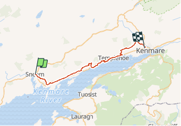
Randonnée Autre activité de 29 km à découvrir à Inconnu, County Kerry, Kenmare Municipal District. Cette randonnée est proposée par bffcuc. Légendes | Plus de détails (PDF) Profil altimétrique Légendes > 15% 15% - 10% 10% - 5% à plat 5% - 10% 10% - 15% 15% - 30% > 30% Localisation Pays : Irlande Région : Inconnu Département/Province : County Kerry Commune : Kenmare Municipal District Localité : Sneem Départ:(Dec) 51.838186 / -9.896856 Départ:(UTM) 438209 ; 5743421 (29U) N. Commentaires Veuillez vous connecter pour laisser un commentaire ou une note Randonnées à proximité Tournan KW08 - Sneem - Kenmare Marche Moyen Kenmare Municipal District, Inconnu, County Kerry, Irlande 31 km | 39 km-effort 8h 25min Non