![](/images/other/stat-length.png)
![Randonnée Marche Uzeste - Uzeste Villandrault Uzeste - Photo](https://media.geolcdn.com/t/1900/400/ext.pjpeg?maxdim=2&url=https%3A%2F%2Fstatic1.geolcdn.com%2Fsiteimages%2Fupload%2Ffiles%2F1553511878bg_sport_marche.png)
Uzeste Villandrault Uzeste
plavengut
Utilisateur
![Longueur](/images/other/stat-length.png)
Longueur
13,5 km
![Altitude max](https://static1.geolcdn.com/siteimages/upload/files/1508320355ic_sort_altitude_max_24dp.png)
Altitude max
79 m
![Dénivelé positif](https://static1.geolcdn.com/siteimages/upload/files/1508320355ic_sort_den_pos_24dp.png)
Dénivelé positif
127 m
![Km-Effort](/images/other/stat-length.png)
Km-Effort
15,2 km
![Altitude min](https://static1.geolcdn.com/siteimages/upload/files/1508320355ic_sort_altitude_min_24dp.png)
Altitude min
25 m
![Dénivelé négatif](https://static1.geolcdn.com/siteimages/upload/files/1508320355ic_sort_den_neg_24dp.png)
Dénivelé négatif
129 m
![Boucle](https://static1.geolcdn.com/siteimages/upload/files/16400158638029165_repeat_loop_refresh_sync_direction_icon.png)
Boucle
Oui
Date de création :
2021-05-07 07:02:55.894
Dernière modification :
2021-05-07 16:23:21.623
![Marche](https://static1.geolcdn.com/sitytour/trail-icons/101.png)
4h00
Difficulté : Facile
![Scannez ce code QR pour ouvrir la randonnée dans l'application SityTrail](https://capi.geolives.com/qq0zvz2zws4bq2lad0pu/sitytour/trails/2776750/qr.png?size=200)
Application GPS de randonnée GRATUITE
À propos
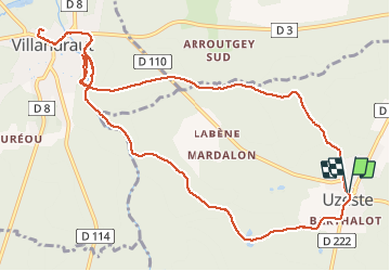
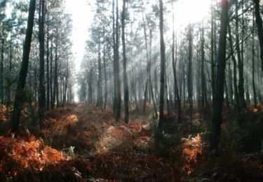
Randonnée Marche de 13,5 km à découvrir à Nouvelle-Aquitaine, Gironde, Uzeste. Cette randonnée est proposée par plavengut.
Description
Boucle dans la forêt et le long du Ciron. Région marquée par le pape Clément V avec les ruines du château de Villandrault et la collégiale d'Uzeste avec son tombeau.
Localisation
Pays :
France
Région :
Nouvelle-Aquitaine
Département/Province :
Gironde
Commune :
Uzeste
Localité :
Unknown
Départ:(Dec)
Départ:(UTM)
712932 ; 4924441 (30T) N.
Commentaires
Randonnées à proximité
![Randonnée A pied Villandraut - Boucle locale de Villandraut - Photo](https://media.geolcdn.com/t/375/260/2ff515c3-9235-4bd7-bf6f-44eeacebe61d.jpeg&format=jpg&maxdim=2)
![A pied A pied](https://static1.geolcdn.com/sitytour/trail-icons/100.png)
Boucle locale de Villandraut
A pied
Facile
Villandraut,
Nouvelle-Aquitaine,
Gironde,
France
![](/images/other/stat-length.png)
6,2 km | 6,8 km-effort
1h 33min
![](https://static1.geolcdn.com/siteimages/upload/files/16400158638029165_repeat_loop_refresh_sync_direction_icon.png)
Non
![Randonnée Canoë - kayak Préchac - Prechac/Bommes - Photo](https://media.geolcdn.com/t/375/260/73c53c6d-3bec-473a-8d15-9acc26d7768b.jpg&format=jpg&maxdim=2)
![Canoë - kayak Canoë - kayak](https://static1.geolcdn.com/sitytour/trail-icons/703.png)
Prechac/Bommes
Canoë - kayak
Moyen
Préchac,
Nouvelle-Aquitaine,
Gironde,
France
![](/images/other/stat-length.png)
19,4 km | 21 km-effort
3h 58min
![](https://static1.geolcdn.com/siteimages/upload/files/16400158638029165_repeat_loop_refresh_sync_direction_icon.png)
Non
![Randonnée Marche Préchac - Prechac 2 - Photo](https://media.geolcdn.com/t/375/260/284bae84-c1d3-4377-b88f-be4046f09f12.jpg&format=jpg&maxdim=2)
![Marche Marche](https://static1.geolcdn.com/sitytour/trail-icons/101.png)
Prechac 2
Marche
Moyen
Préchac,
Nouvelle-Aquitaine,
Gironde,
France
![](/images/other/stat-length.png)
10,2 km | 11,4 km-effort
2h 36min
![](https://static1.geolcdn.com/siteimages/upload/files/16400158638029165_repeat_loop_refresh_sync_direction_icon.png)
Oui
![Randonnée Canoë - kayak Villandraut - Descente du coton - Photo](https://media.geolcdn.com/t/375/260/20f4b854-418e-4f52-aba3-81df09bba3f1.jpg&format=jpg&maxdim=2)
![Canoë - kayak Canoë - kayak](https://static1.geolcdn.com/sitytour/trail-icons/703.png)
Descente du coton
Canoë - kayak
Très facile
Villandraut,
Nouvelle-Aquitaine,
Gironde,
France
![](/images/other/stat-length.png)
19,4 km | 21 km-effort
4h 13min
![](https://static1.geolcdn.com/siteimages/upload/files/16400158638029165_repeat_loop_refresh_sync_direction_icon.png)
Non
![Randonnée V.T.T. Pompéjac - Autour de Pompéjac - Photo](https://media.geolcdn.com/t/375/260/ext.jpg?maxdim=2&url=https%3A%2F%2Fservices.sitytrail.com%2FGeolivesWS%2FDownloadMedia.ashx%3FTrailID%3D102790%26Media%3D3952_1.jpg)
![V.T.T. V.T.T.](https://static1.geolcdn.com/sitytour/trail-icons/202.png)
Autour de Pompéjac
V.T.T.
Moyen
Pompéjac,
Nouvelle-Aquitaine,
Gironde,
France
![](/images/other/stat-length.png)
28 km | 32 km-effort
3h 0min
![](https://static1.geolcdn.com/siteimages/upload/files/16400158638029165_repeat_loop_refresh_sync_direction_icon.png)
Oui
![Randonnée Marche Villandraut - Villandraut - Photo](https://media.geolcdn.com/t/375/260/ext.jpg?maxdim=2&url=https%3A%2F%2Fstatic1.geolcdn.com%2Fsiteimages%2Fupload%2Ffiles%2F1553511878bg_sport_marche.png)
![Marche Marche](https://static1.geolcdn.com/sitytour/trail-icons/101.png)
Villandraut
Marche
Villandraut,
Nouvelle-Aquitaine,
Gironde,
France
![](/images/other/stat-length.png)
11,9 km | 13,2 km-effort
3h 4min
![](https://static1.geolcdn.com/siteimages/upload/files/16400158638029165_repeat_loop_refresh_sync_direction_icon.png)
Oui
![Randonnée Marche Uzeste - Uzeste Villandrault Ar - Photo](https://media.geolcdn.com/t/375/260/ext.jpg?maxdim=2&url=https%3A%2F%2Fstatic1.geolcdn.com%2Fsiteimages%2Fupload%2Ffiles%2F1553511878bg_sport_marche.png)
![Marche Marche](https://static1.geolcdn.com/sitytour/trail-icons/101.png)
Uzeste Villandrault Ar
Marche
Difficile
Uzeste,
Nouvelle-Aquitaine,
Gironde,
France
![](/images/other/stat-length.png)
13,9 km | 15,7 km-effort
4h 0min
![](https://static1.geolcdn.com/siteimages/upload/files/16400158638029165_repeat_loop_refresh_sync_direction_icon.png)
Oui
![Randonnée Randonnée équestre Roaillan - Roaillan - Sanguinet - Photo](https://media.geolcdn.com/t/375/260/ext.jpg?maxdim=2&url=https%3A%2F%2Fstatic1.geolcdn.com%2Fsiteimages%2Fupload%2Ffiles%2F1524743154cheval.jpg)
![Randonnée équestre Randonnée équestre](https://static1.geolcdn.com/sitytour/trail-icons/301.png)
Roaillan - Sanguinet
Randonnée équestre
Moyen
Roaillan,
Nouvelle-Aquitaine,
Gironde,
France
![](/images/other/stat-length.png)
92 km | 101 km-effort
3h 19min
![](https://static1.geolcdn.com/siteimages/upload/files/16400158638029165_repeat_loop_refresh_sync_direction_icon.png)
Non
![Randonnée Marche Villandraut - Villandrau PNL - Photo](https://media.geolcdn.com/t/375/260/ext.jpg?maxdim=2&url=https%3A%2F%2Fstatic1.geolcdn.com%2Fsiteimages%2Fupload%2Ffiles%2F1553511878bg_sport_marche.png)
![Marche Marche](https://static1.geolcdn.com/sitytour/trail-icons/101.png)
Villandrau PNL
Marche
Villandraut,
Nouvelle-Aquitaine,
Gironde,
France
![](/images/other/stat-length.png)
9,5 km | 10,6 km-effort
2h 34min
![](https://static1.geolcdn.com/siteimages/upload/files/16400158638029165_repeat_loop_refresh_sync_direction_icon.png)
Oui