![](/images/other/stat-length.png)
![Randonnée Marche Ombrée-d'Anjou - Grugé-l'Hopital ,SENTIER DU VAL D'ARAIZE - Photo](https://media.geolcdn.com/t/1900/400/ext.pjpeg?maxdim=2&url=https%3A%2F%2Fstatic1.geolcdn.com%2Fsiteimages%2Fupload%2Ffiles%2F1553511878bg_sport_marche.png)
Grugé-l'Hopital ,SENTIER DU VAL D'ARAIZE
JMJ53350
Utilisateur
![Longueur](/images/other/stat-length.png)
Longueur
12,6 km
![Altitude max](https://static1.geolcdn.com/siteimages/upload/files/1508320355ic_sort_altitude_max_24dp.png)
Altitude max
113 m
![Dénivelé positif](https://static1.geolcdn.com/siteimages/upload/files/1508320355ic_sort_den_pos_24dp.png)
Dénivelé positif
142 m
![Km-Effort](/images/other/stat-length.png)
Km-Effort
14,5 km
![Altitude min](https://static1.geolcdn.com/siteimages/upload/files/1508320355ic_sort_altitude_min_24dp.png)
Altitude min
50 m
![Dénivelé négatif](https://static1.geolcdn.com/siteimages/upload/files/1508320355ic_sort_den_neg_24dp.png)
Dénivelé négatif
141 m
![Boucle](https://static1.geolcdn.com/siteimages/upload/files/16400158638029165_repeat_loop_refresh_sync_direction_icon.png)
Boucle
Oui
Date de création :
2021-05-01 21:12:29.33
Dernière modification :
2021-05-01 21:14:15.991
![Marche](https://static1.geolcdn.com/sitytour/trail-icons/101.png)
3h17
Difficulté : Facile
![Scannez ce code QR pour ouvrir la randonnée dans l'application SityTrail](https://capi.geolives.com/qq0zvz2zws4bq2lad0pu/sitytour/trails/2769377/qr.png?size=200)
Application GPS de randonnée GRATUITE
À propos
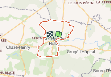
Randonnée Marche de 12,6 km à découvrir à Pays de la Loire, Maine-et-Loire, Ombrée-d'Anjou. Cette randonnée est proposée par JMJ53350.
Description
Le paysage qui peut sembler plat, offre en fait un véritable vallonnement. Le territoire est situé dans le Massif Armoricain. L'érosion a fait naître des lignes de crêtes séparées par les vallons de l'Araize et de la Verzée.
Localisation
Pays :
France
Région :
Pays de la Loire
Département/Province :
Maine-et-Loire
Commune :
Ombrée-d'Anjou
Localité :
Unknown
Départ:(Dec)
Départ:(UTM)
644622 ; 5291232 (30T) N.
Commentaires
Randonnées à proximité
![Randonnée Marche Renazé - Renazé Voie verte - Photo](https://media.geolcdn.com/t/375/260/ext.jpg?maxdim=2&url=https%3A%2F%2Fstatic1.geolcdn.com%2Fsiteimages%2Fupload%2Ffiles%2F1553511878bg_sport_marche.png)
![Marche Marche](https://static1.geolcdn.com/sitytour/trail-icons/101.png)
Renazé Voie verte
Marche
Moyen
Renazé,
Pays de la Loire,
Mayenne,
France
![](/images/other/stat-length.png)
10,3 km | 11,8 km-effort
5h 0min
![](https://static1.geolcdn.com/siteimages/upload/files/16400158638029165_repeat_loop_refresh_sync_direction_icon.png)
Oui
![Randonnée Marche Renazé - Renazé - Photo](https://media.geolcdn.com/t/375/260/ext.jpg?maxdim=2&url=https%3A%2F%2Fstatic1.geolcdn.com%2Fsiteimages%2Fupload%2Ffiles%2F1553511878bg_sport_marche.png)
![Marche Marche](https://static1.geolcdn.com/sitytour/trail-icons/101.png)
![Randonnée V.T.T. Ombrée-d'Anjou - Tour de la forêt de Bel Air de Combrée VTT - Photo](https://media.geolcdn.com/t/375/260/ext.jpg?maxdim=2&url=https%3A%2F%2Fstatic1.geolcdn.com%2Fsiteimages%2Fupload%2Ffiles%2F1524743154velo.jpg)
![V.T.T. V.T.T.](https://static1.geolcdn.com/sitytour/trail-icons/202.png)
Tour de la forêt de Bel Air de Combrée VTT
V.T.T.
Facile
Ombrée-d'Anjou,
Pays de la Loire,
Maine-et-Loire,
France
![](/images/other/stat-length.png)
18,9 km | 21 km-effort
1h 25min
![](https://static1.geolcdn.com/siteimages/upload/files/16400158638029165_repeat_loop_refresh_sync_direction_icon.png)
Oui
![Randonnée Marche Ombrée-d'Anjou - La Chapelle Hulin, val d'Araize - Photo](https://media.geolcdn.com/t/375/260/ext.jpg?maxdim=2&url=https%3A%2F%2Fstatic1.geolcdn.com%2Fsiteimages%2Fupload%2Ffiles%2F1553511878bg_sport_marche.png)
![Marche Marche](https://static1.geolcdn.com/sitytour/trail-icons/101.png)
La Chapelle Hulin, val d'Araize
Marche
Facile
Ombrée-d'Anjou,
Pays de la Loire,
Maine-et-Loire,
France
![](/images/other/stat-length.png)
12,6 km | 14,5 km-effort
3h 17min
![](https://static1.geolcdn.com/siteimages/upload/files/16400158638029165_repeat_loop_refresh_sync_direction_icon.png)
Oui
![Randonnée Marche Armaillé - Armaillé - Photo](https://media.geolcdn.com/t/375/260/ext.jpg?maxdim=2&url=https%3A%2F%2Fstatic1.geolcdn.com%2Fsiteimages%2Fupload%2Ffiles%2F1553511878bg_sport_marche.png)
![Marche Marche](https://static1.geolcdn.com/sitytour/trail-icons/101.png)
Armaillé
Marche
Facile
Armaillé,
Pays de la Loire,
Maine-et-Loire,
France
![](/images/other/stat-length.png)
11 km | 12,4 km-effort
2h 48min
![](https://static1.geolcdn.com/siteimages/upload/files/16400158638029165_repeat_loop_refresh_sync_direction_icon.png)
Oui
![Randonnée sport Armaillé - Sentier du Menhir
- Photo](https://media.geolcdn.com/t/375/260/ext.jpg?maxdim=2&url=https%3A%2F%2Fsecurestorage.geolives.com%2Fsitytour%2Ftrail-bg%2Fdefault.jpg)
Sentier du Menhir
sport
Très facile
Armaillé,
Pays de la Loire,
Maine-et-Loire,
France
![](/images/other/stat-length.png)
16,5 km | 18,7 km-effort
Inconnu
![](https://static1.geolcdn.com/siteimages/upload/files/16400158638029165_repeat_loop_refresh_sync_direction_icon.png)
Oui
![Randonnée Marche Renazé - Renaze Beucher M - Photo](https://media.geolcdn.com/t/375/260/ext.jpg?maxdim=2&url=https%3A%2F%2Fstatic1.geolcdn.com%2Fsiteimages%2Fupload%2Ffiles%2F1553511878bg_sport_marche.png)
![Marche Marche](https://static1.geolcdn.com/sitytour/trail-icons/101.png)
Renaze Beucher M
Marche
Très facile
Renazé,
Pays de la Loire,
Mayenne,
France
![](/images/other/stat-length.png)
9 km | 10,2 km-effort
2h 30min
![](https://static1.geolcdn.com/siteimages/upload/files/16400158638029165_repeat_loop_refresh_sync_direction_icon.png)
Oui