![](/images/other/stat-length.png)
![Randonnée Marche Vexin-sur-Epte - Aveny, Dampsmesnil, L'allée couverte - Photo](https://media.geolcdn.com/t/1900/400/ext.pjpeg?maxdim=2&url=https%3A%2F%2Fstatic1.geolcdn.com%2Fsiteimages%2Fupload%2Ffiles%2F1553511878bg_sport_marche.png)
Aveny, Dampsmesnil, L'allée couverte
Marie-Claire-mcp
Utilisateur
![Longueur](/images/other/stat-length.png)
Longueur
10 km
![Altitude max](https://static1.geolcdn.com/siteimages/upload/files/1508320355ic_sort_altitude_max_24dp.png)
Altitude max
139 m
![Dénivelé positif](https://static1.geolcdn.com/siteimages/upload/files/1508320355ic_sort_den_pos_24dp.png)
Dénivelé positif
201 m
![Km-Effort](/images/other/stat-length.png)
Km-Effort
12,7 km
![Altitude min](https://static1.geolcdn.com/siteimages/upload/files/1508320355ic_sort_altitude_min_24dp.png)
Altitude min
37 m
![Dénivelé négatif](https://static1.geolcdn.com/siteimages/upload/files/1508320355ic_sort_den_neg_24dp.png)
Dénivelé négatif
204 m
![Boucle](https://static1.geolcdn.com/siteimages/upload/files/16400158638029165_repeat_loop_refresh_sync_direction_icon.png)
Boucle
Oui
Date de création :
2021-04-30 12:50:29.294
Dernière modification :
2021-04-30 12:54:31.35
![Marche](https://static1.geolcdn.com/sitytour/trail-icons/101.png)
2h52
Difficulté : Difficile
![Scannez ce code QR pour ouvrir la randonnée dans l'application SityTrail](https://capi.geolives.com/qq0zvz2zws4bq2lad0pu/sitytour/trails/2767295/qr.png?size=200)
Application GPS de randonnée GRATUITE
À propos
Randonnée Marche de 10 km à découvrir à Normandie, Eure, Vexin-sur-Epte. Cette randonnée est proposée par Marie-Claire-mcp.
Description
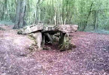
Depart Aveny, route à droite après le cimetière, puis à la sortie d'Aveny prendre un chemin sur la gauche, puis sur la droite, au bout, rue principale de Dampsmesnil, puis un chemin sur la droite jusqu'à L'allée couverte et bois des petits Aulnays et retour Aveny.
Localisation
Pays :
France
Région :
Normandie
Département/Province :
Eure
Commune :
Vexin-sur-Epte
Localité :
Dampsmesnil
Départ:(Dec)
Départ:(UTM)
402381 ; 5446653 (31U) N.
Commentaires
Randonnées à proximité
![Randonnée Marche Château-sur-Epte - Château sur Epte - Berthenonville - Photo](https://media.geolcdn.com/t/375/260/ext.jpg?maxdim=2&url=https%3A%2F%2Fservices.sitytrail.com%2FGeolivesWS%2FDownloadMedia.ashx%3FTrailID%3D891370%26Media%3D28f306c4-ccd7-4e45-8d5f-378c794acdd1.jpg)
![Marche Marche](https://static1.geolcdn.com/sitytour/trail-icons/101.png)
Château sur Epte - Berthenonville
Marche
Facile
(1)
Château-sur-Epte,
Normandie,
Eure,
France
![](/images/other/stat-length.png)
7,8 km | 9,5 km-effort
2h 7min
![](https://static1.geolcdn.com/siteimages/upload/files/16400158638029165_repeat_loop_refresh_sync_direction_icon.png)
Oui
![Randonnée Marche Château-sur-Epte - Château sur Epte - Rollon Nord - Photo](https://media.geolcdn.com/t/375/260/ext.jpg?maxdim=2&url=https%3A%2F%2Fservices.sitytrail.com%2FGeolivesWS%2FDownloadMedia.ashx%3FTrailID%3D158414%26Media%3Df92478f2-a815-4319-b098-de4877cf6291.jpg)
![Marche Marche](https://static1.geolcdn.com/sitytour/trail-icons/101.png)
Château sur Epte - Rollon Nord
Marche
Facile
(1)
Château-sur-Epte,
Normandie,
Eure,
France
![](/images/other/stat-length.png)
8,4 km | 10,2 km-effort
2h 2min
![](https://static1.geolcdn.com/siteimages/upload/files/16400158638029165_repeat_loop_refresh_sync_direction_icon.png)
Oui
![Randonnée Marche Buhy - De Buchet à Magny en Vexin - Photo](https://media.geolcdn.com/t/375/260/1020b94f-166d-40ac-8266-f51a3f0e5d45.jpg&format=jpg&maxdim=2)
![Marche Marche](https://static1.geolcdn.com/sitytour/trail-icons/101.png)
De Buchet à Magny en Vexin
Marche
Moyen
Buhy,
Île-de-France,
Val-d'Oise,
France
![](/images/other/stat-length.png)
25 km | 29 km-effort
5h 3min
![](https://static1.geolcdn.com/siteimages/upload/files/16400158638029165_repeat_loop_refresh_sync_direction_icon.png)
Non
![Randonnée Marche Vexin-sur-Epte - Château sur Epte variante par pierre tournante - Photo](https://media.geolcdn.com/t/375/260/ext.jpg?maxdim=2&url=https%3A%2F%2Fstatic1.geolcdn.com%2Fsiteimages%2Fupload%2Ffiles%2F1553511878bg_sport_marche.png)
![Marche Marche](https://static1.geolcdn.com/sitytour/trail-icons/101.png)
Château sur Epte variante par pierre tournante
Marche
Facile
(1)
Vexin-sur-Epte,
Normandie,
Eure,
France
![](/images/other/stat-length.png)
9,8 km | 12,1 km-effort
2h 30min
![](https://static1.geolcdn.com/siteimages/upload/files/16400158638029165_repeat_loop_refresh_sync_direction_icon.png)
Oui
![Randonnée Marche Vexin-sur-Epte - Rando Douce 1 - Ecos - Photo](https://media.geolcdn.com/t/375/260/ext.jpg?maxdim=2&url=https%3A%2F%2Fstatic1.geolcdn.com%2Fsiteimages%2Fupload%2Ffiles%2F1553511878bg_sport_marche.png)
![Marche Marche](https://static1.geolcdn.com/sitytour/trail-icons/101.png)
Rando Douce 1 - Ecos
Marche
Facile
(1)
Vexin-sur-Epte,
Normandie,
Eure,
France
![](/images/other/stat-length.png)
6,5 km | 7,6 km-effort
1h 28min
![](https://static1.geolcdn.com/siteimages/upload/files/16400158638029165_repeat_loop_refresh_sync_direction_icon.png)
Oui
![Randonnée Marche Vexin-sur-Epte - Ecos - les trois boucles court - Photo](https://media.geolcdn.com/t/375/260/ext.jpg?maxdim=2&url=https%3A%2F%2Fstatic1.geolcdn.com%2Fsiteimages%2Fupload%2Ffiles%2F1553511878bg_sport_marche.png)
![Marche Marche](https://static1.geolcdn.com/sitytour/trail-icons/101.png)
Ecos - les trois boucles court
Marche
Facile
(2)
Vexin-sur-Epte,
Normandie,
Eure,
France
![](/images/other/stat-length.png)
11,1 km | 13,1 km-effort
2h 51min
![](https://static1.geolcdn.com/siteimages/upload/files/16400158638029165_repeat_loop_refresh_sync_direction_icon.png)
Oui
![Randonnée Marche Omerville - omerville et alentours - Photo](https://media.geolcdn.com/t/375/260/ext.jpg?maxdim=2&url=https%3A%2F%2Fstatic1.geolcdn.com%2Fsiteimages%2Fupload%2Ffiles%2F1553511878bg_sport_marche.png)
![Marche Marche](https://static1.geolcdn.com/sitytour/trail-icons/101.png)
omerville et alentours
Marche
Facile
(3)
Omerville,
Île-de-France,
Val-d'Oise,
France
![](/images/other/stat-length.png)
12,7 km | 16 km-effort
3h 17min
![](https://static1.geolcdn.com/siteimages/upload/files/16400158638029165_repeat_loop_refresh_sync_direction_icon.png)
Oui
![Randonnée Marche Vexin-sur-Epte - Berthenonville Dampsmesni la côte aux chiens - Photo](https://media.geolcdn.com/t/375/260/ext.jpg?maxdim=2&url=https%3A%2F%2Fstatic1.geolcdn.com%2Fsiteimages%2Fupload%2Ffiles%2F1553511878bg_sport_marche.png)
![Marche Marche](https://static1.geolcdn.com/sitytour/trail-icons/101.png)
Berthenonville Dampsmesni la côte aux chiens
Marche
Moyen
(1)
Vexin-sur-Epte,
Normandie,
Eure,
France
![](/images/other/stat-length.png)
9,5 km | 12,7 km-effort
2h 16min
![](https://static1.geolcdn.com/siteimages/upload/files/16400158638029165_repeat_loop_refresh_sync_direction_icon.png)
Oui
![Randonnée Marche Montreuil-sur-Epte - Montreuil sur Epte La Chapelle en Vexin - Photo](https://media.geolcdn.com/t/375/260/ext.jpg?maxdim=2&url=https%3A%2F%2Fstatic1.geolcdn.com%2Fsiteimages%2Fupload%2Ffiles%2F1553511878bg_sport_marche.png)
![Marche Marche](https://static1.geolcdn.com/sitytour/trail-icons/101.png)
Montreuil sur Epte La Chapelle en Vexin
Marche
Difficile
(1)
Montreuil-sur-Epte,
Île-de-France,
Val-d'Oise,
France
![](/images/other/stat-length.png)
11,1 km | 13,6 km-effort
3h 48min
![](https://static1.geolcdn.com/siteimages/upload/files/16400158638029165_repeat_loop_refresh_sync_direction_icon.png)
Oui