![](/images/other/stat-length.png)
![Randonnée Marche Wegscheid - la réserve naturelle de la forêt des volcans depuis wegscheid - Photo](https://media.geolcdn.com/t/1900/400/59563836-d37d-475a-aa89-3ca5bb979f0b.jpg&format=pjpeg&maxdim=2)
la réserve naturelle de la forêt des volcans depuis wegscheid
margotte
Utilisateur
![Longueur](/images/other/stat-length.png)
Longueur
14,4 km
![Altitude max](https://static1.geolcdn.com/siteimages/upload/files/1508320355ic_sort_altitude_max_24dp.png)
Altitude max
1174 m
![Dénivelé positif](https://static1.geolcdn.com/siteimages/upload/files/1508320355ic_sort_den_pos_24dp.png)
Dénivelé positif
806 m
![Km-Effort](/images/other/stat-length.png)
Km-Effort
25 km
![Altitude min](https://static1.geolcdn.com/siteimages/upload/files/1508320355ic_sort_altitude_min_24dp.png)
Altitude min
525 m
![Dénivelé négatif](https://static1.geolcdn.com/siteimages/upload/files/1508320355ic_sort_den_neg_24dp.png)
Dénivelé négatif
797 m
![Boucle](https://static1.geolcdn.com/siteimages/upload/files/16400158638029165_repeat_loop_refresh_sync_direction_icon.png)
Boucle
Oui
Date de création :
2021-04-27 07:46:07.6
Dernière modification :
2021-04-27 13:16:50.894
![Marche](https://static1.geolcdn.com/sitytour/trail-icons/101.png)
3h45
Difficulté : Moyen
![Scannez ce code QR pour ouvrir la randonnée dans l'application SityTrail](https://capi.geolives.com/qq0zvz2zws4bq2lad0pu/sitytour/trails/2764197/qr.png?size=200)
Application GPS de randonnée GRATUITE
À propos
Randonnée Marche de 14,4 km à découvrir à Grand Est, Haut-Rhin, Wegscheid. Cette randonnée est proposée par margotte.
Description
de belles forêts avec des douglas au parfum de citronnelle. de superbes oints de vue depuis les chaumes du rossberg..belacker..sur l'Alsace, le Jura...
Localisation
Pays :
France
Région :
Grand Est
Département/Province :
Haut-Rhin
Commune :
Wegscheid
Localité :
Unknown
Départ:(Dec)
Départ:(UTM)
348098 ; 5297977 (32T) N.
Commentaires
Randonnées à proximité
![Randonnée Marche Masevaux-Niederbruck - Masevaux - Rossberg par le belvédère du Fuchsfelsen - Photo](https://media.geolcdn.com/t/375/260/d9cc765c-1250-4953-9d9f-fb8b88eb82a7.jpg&format=jpg&maxdim=2)
![Marche Marche](https://static1.geolcdn.com/sitytour/trail-icons/101.png)
Masevaux - Rossberg par le belvédère du Fuchsfelsen
Marche
Moyen
(1)
Masevaux-Niederbruck,
Grand Est,
Haut-Rhin,
France
![](/images/other/stat-length.png)
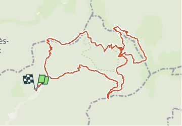
19,9 km | 34 km-effort
4h 44min
![](https://static1.geolcdn.com/siteimages/upload/files/16400158638029165_repeat_loop_refresh_sync_direction_icon.png)
Oui
![Randonnée Marche Rimbach-près-Masevaux - Haute Bers - Photo](https://media.geolcdn.com/t/375/260/263a149f-9c7c-4184-802a-631c78ca66f6.jpg&format=jpg&maxdim=2)
![Marche Marche](https://static1.geolcdn.com/sitytour/trail-icons/101.png)
Haute Bers
Marche
Moyen
(1)
Rimbach-près-Masevaux,
Grand Est,
Haut-Rhin,
France
![](/images/other/stat-length.png)
12 km | 20 km-effort
3h 25min
![](https://static1.geolcdn.com/siteimages/upload/files/16400158638029165_repeat_loop_refresh_sync_direction_icon.png)
Oui
![Randonnée Marche Sewen - Boucle entre les lacs de Sewen et d'Alfeld - Photo](https://media.geolcdn.com/t/375/260/ext.jpg?maxdim=2&url=https%3A%2F%2Fservices.sitytrail.com%2FGeolivesWS%2FDownloadMedia.ashx%3FTrailID%3D103686%26Media%3D6168_4.jpg)
![Marche Marche](https://static1.geolcdn.com/sitytour/trail-icons/101.png)
Boucle entre les lacs de Sewen et d'Alfeld
Marche
Moyen
(1)
Sewen,
Grand Est,
Haut-Rhin,
France
![](/images/other/stat-length.png)
8,1 km | 12,3 km-effort
2h 30min
![](https://static1.geolcdn.com/siteimages/upload/files/16400158638029165_repeat_loop_refresh_sync_direction_icon.png)
Oui
![Randonnée Marche Storckensohn - lac des perches marchettes - Photo](https://media.geolcdn.com/t/375/260/ba8e93c4-c66a-48b1-88b8-cca79cc3effc.jpg&format=jpg&maxdim=2)
![Marche Marche](https://static1.geolcdn.com/sitytour/trail-icons/101.png)
lac des perches marchettes
Marche
Moyen
(1)
Storckensohn,
Grand Est,
Haut-Rhin,
France
![](/images/other/stat-length.png)
11,9 km | 20 km-effort
4h 8min
![](https://static1.geolcdn.com/siteimages/upload/files/16400158638029165_repeat_loop_refresh_sync_direction_icon.png)
Oui
![Randonnée Marche Dolleren - 2025-01-02 Rando Polaire Dolleren Ballon Alsace Etape 1 - Photo](https://media.geolcdn.com/t/375/260/98b6c1e4-75f0-464a-86a1-edc427e75210.jpg&format=jpg&maxdim=2)
![Marche Marche](https://static1.geolcdn.com/sitytour/trail-icons/101.png)
2025-01-02 Rando Polaire Dolleren Ballon Alsace Etape 1
Marche
Moyen
Dolleren,
Grand Est,
Haut-Rhin,
France
![](/images/other/stat-length.png)
4,3 km | 8,1 km-effort
1h 50min
![](https://static1.geolcdn.com/siteimages/upload/files/16400158638029165_repeat_loop_refresh_sync_direction_icon.png)
Non
![Randonnée Marche Storckensohn - 2022-07-16 Marche Auberge Gazon Vert Chapelle des Ves - Photo](https://media.geolcdn.com/t/375/260/7aac2105-88e6-44f1-a6d0-d41240d9f4c5.jpg&format=jpg&maxdim=2)
![Marche Marche](https://static1.geolcdn.com/sitytour/trail-icons/101.png)
2022-07-16 Marche Auberge Gazon Vert Chapelle des Ves
Marche
Très difficile
Storckensohn,
Grand Est,
Haut-Rhin,
France
![](/images/other/stat-length.png)
21 km | 37 km-effort
6h 11min
![](https://static1.geolcdn.com/siteimages/upload/files/16400158638029165_repeat_loop_refresh_sync_direction_icon.png)
Non
![Randonnée Marche Kirchberg - 2022-07-15 Marche Refuge Baerenkopf Auberge Gazon Vert - Photo](https://media.geolcdn.com/t/375/260/d5c191fc-95a3-4bb1-8368-e694339cee76.jpg&format=jpg&maxdim=2)
![Marche Marche](https://static1.geolcdn.com/sitytour/trail-icons/101.png)
2022-07-15 Marche Refuge Baerenkopf Auberge Gazon Vert
Marche
Très difficile
Kirchberg,
Grand Est,
Haut-Rhin,
France
![](/images/other/stat-length.png)
23 km | 38 km-effort
8h 21min
![](https://static1.geolcdn.com/siteimages/upload/files/16400158638029165_repeat_loop_refresh_sync_direction_icon.png)
Non
![Randonnée Marche Rimbach-près-Masevaux - Les deux lacs - Photo](https://media.geolcdn.com/t/375/260/ec102df6-1fd0-42bb-8bbd-9523bd80f1a9.jpg&format=jpg&maxdim=2)
![Marche Marche](https://static1.geolcdn.com/sitytour/trail-icons/101.png)
Les deux lacs
Marche
Difficile
Rimbach-près-Masevaux,
Grand Est,
Haut-Rhin,
France
![](/images/other/stat-length.png)
15,5 km | 25 km-effort
5h 47min
![](https://static1.geolcdn.com/siteimages/upload/files/16400158638029165_repeat_loop_refresh_sync_direction_icon.png)
Oui
![Randonnée Marche Wegscheid - FucksfelsenBelacker - Photo](https://media.geolcdn.com/t/375/260/ac608221-de91-4d0b-89a9-d4cab6086d15.jpg&format=jpg&maxdim=2)
![Marche Marche](https://static1.geolcdn.com/sitytour/trail-icons/101.png)
FucksfelsenBelacker
Marche
Moyen
Wegscheid,
Grand Est,
Haut-Rhin,
France
![](/images/other/stat-length.png)
14,4 km | 24 km-effort
4h 9min
![](https://static1.geolcdn.com/siteimages/upload/files/16400158638029165_repeat_loop_refresh_sync_direction_icon.png)
Oui