Randonnée Marche Vaals - Vaals 15km - Photo
© OpenStreetMap contributors
Longueur
Longueur
14,9 km
Altitude max
Altitude max
298 m
Dénivelé positif
Dénivelé positif
264 m
Km-Effort
Km-Effort  
18,5 km
Altitude min
Altitude min
144 m
Dénivelé négatif
Dénivelé négatif
270 m
Boucle
Boucle
Oui
Date de création :
2014-12-10 00:00:00.0
Dernière modification :
2014-12-10 00:00:00.0

(1 Avis)

Marche
Marche
--
Difficulté : Inconnu

Scannez ce code QR pour ouvrir la randonnée dans l'application SityTrail

Application GPS de randonnée GRATUITE

Logo SityTrail SityTrail

IGN / Instituts géographiques

Télécharger SityTrail sur l'App Store Télécharger SityTrail sur Google Play

Logo SityTrail SityTrail World

Le monde est à vous

Télécharger SityTrail sur l'App Store Télécharger SityTrail sur Google Play Télécharger SityTrail sur Huawei AppGallery

À propos

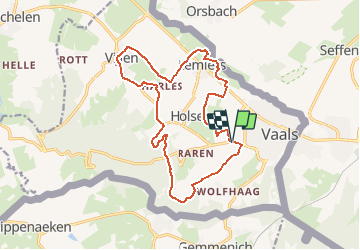
Randonnée Marche de 14,9 km à découvrir à Limbourg, Inconnu, Vaals. Cette randonnée est proposée par wandelgidszuidlimburg.

Description

More information on : http://www.wandelgidszuidlimburg.com

Profil altimétrique

Points d'intérêt

Point d'intérêt Vaals - Let op! - Photo
wandelgidszuidlimburg
VAALS 
Point d'intérêt Vaals - start_306 - Photo
wandelgidszuidlimburg
VAALS 

Localisation

Pays :
Pays-Bas
Région :
Limbourg
Département/Province :
Inconnu
Commune :
Vaals
Localité :
Unknown
Départ:(Dec)
Départ:(UTM)
288665 ; 5628442 (32U) N.

Commentaires

Veuillez vous connecter pour laisser un commentaire ou une note


Faite 2 x en 2020, très beau parcours. n° 306


Randonnées à proximité

Randonnée Marche Vaals - Lemiers _788 - Photo
Marche
GUIDE
mumu.larandonneuse

Marche

Moyen
(1)
Vaals, Limbourg, Inconnu, Pays-Bas
12,9 km | 16,3 km-effort
3h 42min
Oui
Randonnée Marche Vaals - Lemiers _235 - Photo
Marche
GUIDE
mumu.larandonneuse

Marche

Moyen
(1)
Vaals, Limbourg, Inconnu, Pays-Bas
14,7 km | 18,3 km-effort
4h 9min
Oui
Randonnée Marche Aix-la-Chapelle - Aix-la-Chapelle  - Photo
Marche
GUIDE
mumu.larandonneuse

Marche

Facile
(1)
Aix-la-Chapelle, Rhénanie-du-Nord-Westphalie, Région urbaine d'Aix-la-Chapelle, Allemagne
11,4 km | 15,4 km-effort
3h 30min
Oui
Randonnée Marche Vaals - Wandelroute---cittaslow-rondje-viele - Photo
Marche
GUIDE
mumu.larandonneuse

Marche

Moyen
(1)
Vaals, Limbourg, Inconnu, Pays-Bas
12,8 km | 17,1 km-effort
3h 53min
Oui
Randonnée Marche Vaals - Vaals_1431 - Photo
Marche
GUIDE
mumu.larandonneuse

Marche

Moyen
(1)
Vaals, Limbourg, Inconnu, Pays-Bas
13,1 km | 16,6 km-effort
3h 46min
Oui
Randonnée Marche Gulpen-Wittem - Wahlwiller_077 - Photo
Marche
GUIDE
mumu.larandonneuse

Marche

Facile
(1)
Gulpen-Wittem, Limbourg, Inconnu, Pays-Bas
16,4 km | 20 km-effort
4h 35min
Oui
Randonnée Marche Gulpen-Wittem - Wahlwiller  - Photo
Marche
GUIDE
mumu.larandonneuse

Marche

Facile
(1)
Gulpen-Wittem, Limbourg, Inconnu, Pays-Bas
15,1 km | 19,3 km-effort
4h 23min
Oui
Randonnée Marche La Calamine - 20200730 - Les 3 Bornes 7.3 Km - Photo
Marche
GUIDE
pierreh01

Marche

Difficile
(1)
La Calamine, Wallonie, Liège, Belgique
7,4 km | 10,4 km-effort
1h 50min
Oui
Randonnée Marche La Calamine - Venn Trilogie (1er étape) - Photo
Marche
Godasses et Grosses Pattes

Marche

Moyen
(1)
La Calamine, Wallonie, Liège, Belgique
25 km | 30 km-effort
5h 0min
Non


Fermer
Mes abonnements