![](/images/other/stat-length.png)
![Randonnée Marche Saint-Prest - Départ Saint-Prest , Oiseme, champhol, - Photo](https://media.geolcdn.com/t/1900/400/ext.pjpeg?maxdim=2&url=https%3A%2F%2Fstatic1.geolcdn.com%2Fsiteimages%2Fupload%2Ffiles%2F1553511878bg_sport_marche.png)
Départ Saint-Prest , Oiseme, champhol,
ezola
Utilisateur
![Longueur](/images/other/stat-length.png)
Longueur
10 km
![Altitude max](https://static1.geolcdn.com/siteimages/upload/files/1508320355ic_sort_altitude_max_24dp.png)
Altitude max
154 m
![Dénivelé positif](https://static1.geolcdn.com/siteimages/upload/files/1508320355ic_sort_den_pos_24dp.png)
Dénivelé positif
97 m
![Km-Effort](/images/other/stat-length.png)
Km-Effort
11,3 km
![Altitude min](https://static1.geolcdn.com/siteimages/upload/files/1508320355ic_sort_altitude_min_24dp.png)
Altitude min
113 m
![Dénivelé négatif](https://static1.geolcdn.com/siteimages/upload/files/1508320355ic_sort_den_neg_24dp.png)
Dénivelé négatif
97 m
![Boucle](https://static1.geolcdn.com/siteimages/upload/files/16400158638029165_repeat_loop_refresh_sync_direction_icon.png)
Boucle
Oui
Date de création :
2021-04-24 11:33:20.0
Dernière modification :
2021-04-24 14:16:56.395
![Marche](https://static1.geolcdn.com/sitytour/trail-icons/101.png)
2h26
Difficulté : Moyen
![Scannez ce code QR pour ouvrir la randonnée dans l'application SityTrail](https://capi.geolives.com/qq0zvz2zws4bq2lad0pu/sitytour/trails/2759904/qr.png?size=200)
Application GPS de randonnée GRATUITE
À propos
Randonnée Marche de 10 km à découvrir à Centre-Val de Loire, Eure-et-Loir, Saint-Prest. Cette randonnée est proposée par ezola.
Description
Prends le pont en montant à Saint-Prêts, tout de suite à droite ensuite direction Oiseme, puis Champhol puis retour
Localisation
Pays :
France
Région :
Centre-Val de Loire
Département/Province :
Eure-et-Loir
Commune :
Saint-Prest
Localité :
Unknown
Départ:(Dec)
Départ:(UTM)
391794 ; 5371873 (31U) N.
Commentaires
Randonnées à proximité
![Randonnée Marche Chartres - Parcours de la ville historique de Chartres - Photo](https://media.geolcdn.com/t/375/260/5e4a7e3c-abb5-42c8-8b44-13932b698f48.jpg&format=jpg&maxdim=2)
![Marche Marche](https://static1.geolcdn.com/sitytour/trail-icons/101.png)
Parcours de la ville historique de Chartres
Marche
Très facile
Chartres,
Centre-Val de Loire,
Eure-et-Loir,
France
![](/images/other/stat-length.png)
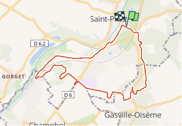
7,7 km | 8,9 km-effort
2h 13min
![](https://static1.geolcdn.com/siteimages/upload/files/16400158638029165_repeat_loop_refresh_sync_direction_icon.png)
Non
![Randonnée Marche Chartres - balade autour cathédrale de Chartres - Photo](https://media.geolcdn.com/t/375/260/589e1a6c-9aee-41e4-b0c1-21e1dc04e42e.jpg&format=jpg&maxdim=2)
![Marche Marche](https://static1.geolcdn.com/sitytour/trail-icons/101.png)
balade autour cathédrale de Chartres
Marche
Facile
Chartres,
Centre-Val de Loire,
Eure-et-Loir,
France
![](/images/other/stat-length.png)
5,3 km | 6,1 km-effort
2h 31min
![](https://static1.geolcdn.com/siteimages/upload/files/16400158638029165_repeat_loop_refresh_sync_direction_icon.png)
Oui
![Randonnée Marche Saint-Prest - St prèst>> Soulaires>>jouy >> St prest - Photo](https://media.geolcdn.com/t/375/260/ea64a9c0-2691-49ad-9b96-29e6fbe97de4.jpg&format=jpg&maxdim=2)
![Marche Marche](https://static1.geolcdn.com/sitytour/trail-icons/101.png)
St prèst>> Soulaires>>jouy >> St prest
Marche
Très difficile
Saint-Prest,
Centre-Val de Loire,
Eure-et-Loir,
France
![](/images/other/stat-length.png)
21 km | 24 km-effort
4h 46min
![](https://static1.geolcdn.com/siteimages/upload/files/16400158638029165_repeat_loop_refresh_sync_direction_icon.png)
Oui
![Randonnée Marche Gasville-Oisème - proj 2020_20190716Oiseme - Photo](https://media.geolcdn.com/t/375/260/ext.jpg?maxdim=2&url=https%3A%2F%2Fstatic1.geolcdn.com%2Fsiteimages%2Fupload%2Ffiles%2F1553511878bg_sport_marche.png)
![Marche Marche](https://static1.geolcdn.com/sitytour/trail-icons/101.png)
proj 2020_20190716Oiseme
Marche
Très facile
(1)
Gasville-Oisème,
Centre-Val de Loire,
Eure-et-Loir,
France
![](/images/other/stat-length.png)
10,8 km | 12,7 km-effort
2h 35min
![](https://static1.geolcdn.com/siteimages/upload/files/16400158638029165_repeat_loop_refresh_sync_direction_icon.png)
Oui
![Randonnée Marche Soulaires - Soulaires, Saint Piat - Photo](https://media.geolcdn.com/t/375/260/f9607bd4-1b77-41c8-a6fe-0b390a071e6b.jpg&format=jpg&maxdim=2)
![Marche Marche](https://static1.geolcdn.com/sitytour/trail-icons/101.png)
Soulaires, Saint Piat
Marche
Très facile
Soulaires,
Centre-Val de Loire,
Eure-et-Loir,
France
![](/images/other/stat-length.png)
13,8 km | 16,5 km-effort
3h 17min
![](https://static1.geolcdn.com/siteimages/upload/files/16400158638029165_repeat_loop_refresh_sync_direction_icon.png)
Non
![Randonnée V.T.T. Mainvilliers - Les planeurs de la base des planeurs d''Armenonville - Chartres - Photo](https://media.geolcdn.com/t/375/260/ext.jpg?maxdim=2&url=https%3A%2F%2Fservices.sitytrail.com%2FGeolivesWS%2FDownloadMedia.ashx%3FTrailID%3D172818%26Media%3D14251_6.jpg)
![V.T.T. V.T.T.](https://static1.geolcdn.com/sitytour/trail-icons/202.png)
Les planeurs de la base des planeurs d''Armenonville - Chartres
V.T.T.
Moyen
(1)
Mainvilliers,
Centre-Val de Loire,
Eure-et-Loir,
France
![](/images/other/stat-length.png)
53 km | 60 km-effort
4h 0min
![](https://static1.geolcdn.com/siteimages/upload/files/16400158638029165_repeat_loop_refresh_sync_direction_icon.png)
Oui
![Randonnée Marche nordique Chartres - 2024 MB Jardin d'horticulture, Lèves - Photo](https://media.geolcdn.com/t/375/260/0e4f5937-b923-45b6-86aa-21a4f2d5122d.jpg&format=jpg&maxdim=2)
![Marche nordique Marche nordique](https://static1.geolcdn.com/sitytour/trail-icons/102.png)
2024 MB Jardin d'horticulture, Lèves
Marche nordique
Facile
Chartres,
Centre-Val de Loire,
Eure-et-Loir,
France
![](/images/other/stat-length.png)
9,4 km | 10,5 km-effort
1h 55min
![](https://static1.geolcdn.com/siteimages/upload/files/16400158638029165_repeat_loop_refresh_sync_direction_icon.png)
Oui
![Randonnée Marche Chartres - 2023 Chartres tour de ville - Photo](https://media.geolcdn.com/t/375/260/dc0d9c93-9da7-45cc-94c6-fd51d08d97c6.jpg&format=jpg&maxdim=2)
![Marche Marche](https://static1.geolcdn.com/sitytour/trail-icons/101.png)
2023 Chartres tour de ville
Marche
Facile
Chartres,
Centre-Val de Loire,
Eure-et-Loir,
France
![](/images/other/stat-length.png)
11,3 km | 12,4 km-effort
1h 58min
![](https://static1.geolcdn.com/siteimages/upload/files/16400158638029165_repeat_loop_refresh_sync_direction_icon.png)
Oui
![Randonnée Marche Jouy - GB Jouy - Photo](https://media.geolcdn.com/t/375/260/c3e7ecf0-3945-40f4-9fca-1dd3d26f6233.jpg&format=jpg&maxdim=2)
![Marche Marche](https://static1.geolcdn.com/sitytour/trail-icons/101.png)
GB Jouy
Marche
Facile
Jouy,
Centre-Val de Loire,
Eure-et-Loir,
France
![](/images/other/stat-length.png)
10,2 km | 12,4 km-effort
2h 36min
![](https://static1.geolcdn.com/siteimages/upload/files/16400158638029165_repeat_loop_refresh_sync_direction_icon.png)
Oui