![](/images/other/stat-length.png)
![Randonnée Marche Treffléan - Treffléan (Bizole - Randrécart - Grand et Petit Tréhornec - Barrage de Trégat) - Photo](https://media.geolcdn.com/t/1900/400/ext.pjpeg?maxdim=2&url=https%3A%2F%2Fstatic1.geolcdn.com%2Fsiteimages%2Fupload%2Ffiles%2F1553511878bg_sport_marche.png)
Treffléan (Bizole - Randrécart - Grand et Petit Tréhornec - Barrage de Trégat)
PAM2235
Utilisateur
![Longueur](/images/other/stat-length.png)
Longueur
10,7 km
![Altitude max](https://static1.geolcdn.com/siteimages/upload/files/1508320355ic_sort_altitude_max_24dp.png)
Altitude max
113 m
![Dénivelé positif](https://static1.geolcdn.com/siteimages/upload/files/1508320355ic_sort_den_pos_24dp.png)
Dénivelé positif
208 m
![Km-Effort](/images/other/stat-length.png)
Km-Effort
13,5 km
![Altitude min](https://static1.geolcdn.com/siteimages/upload/files/1508320355ic_sort_altitude_min_24dp.png)
Altitude min
47 m
![Dénivelé négatif](https://static1.geolcdn.com/siteimages/upload/files/1508320355ic_sort_den_neg_24dp.png)
Dénivelé négatif
207 m
![Boucle](https://static1.geolcdn.com/siteimages/upload/files/16400158638029165_repeat_loop_refresh_sync_direction_icon.png)
Boucle
Oui
Date de création :
2021-04-22 17:30:16.414
Dernière modification :
2021-04-25 17:51:41.316
![Marche](https://static1.geolcdn.com/sitytour/trail-icons/101.png)
2h40
Difficulté : Difficile
![Scannez ce code QR pour ouvrir la randonnée dans l'application SityTrail](https://capi.geolives.com/qq0zvz2zws4bq2lad0pu/sitytour/trails/2757921/qr.png?size=200)
Application GPS de randonnée GRATUITE
À propos
Randonnée Marche de 10,7 km à découvrir à Bretagne, Morbihan, Treffléan. Cette randonnée est proposée par PAM2235.
Description
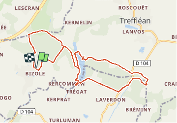
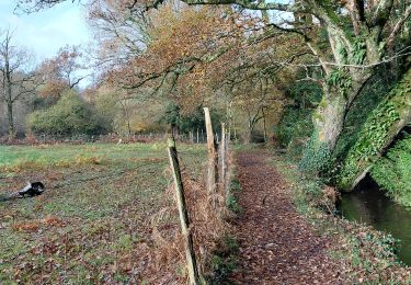
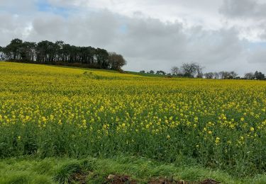
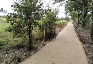
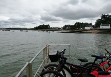
Circuit de 11 km au départ du parking situé au chevet de la chapelle de Bizole. Cette variante du circuit de Bizole permet de le prolonger jusqu'au Petit Tréhornec et de découvrir le barrage de Trégat.
Localisation
Pays :
France
Région :
Bretagne
Département/Province :
Morbihan
Commune :
Treffléan
Localité :
Unknown
Départ:(Dec)
Départ:(UTM)
526382 ; 5279722 (30T) N.
Commentaires
Randonnées à proximité
![Randonnée Marche Treffléan - Bizole - Photo](https://media.geolcdn.com/t/375/260/ext.jpg?maxdim=2&url=https%3A%2F%2Fservices.sitytrail.com%2FGeolivesWS%2FDownloadMedia.ashx%3FTrailID%3D191920%26Media%3Dfb5fe928-9f5d-4af5-aad3-ccb04a0144c1.JPG)
![Marche Marche](https://static1.geolcdn.com/sitytour/trail-icons/101.png)
![Randonnée Marche Treffléan - PR_56_Trefflean_BA_02_Circuit1b_Chemin-De-Cran_20240507 - Photo](https://media.geolcdn.com/t/375/260/b832eb83-9ae2-4127-a1d1-f2e6e6666b1a.jpg&format=jpg&maxdim=2)
![Marche Marche](https://static1.geolcdn.com/sitytour/trail-icons/101.png)
PR_56_Trefflean_BA_02_Circuit1b_Chemin-De-Cran_20240507
Marche
Facile
Treffléan,
Bretagne,
Morbihan,
France
![](/images/other/stat-length.png)
5,4 km | 6,5 km-effort
1h 12min
![](https://static1.geolcdn.com/siteimages/upload/files/16400158638029165_repeat_loop_refresh_sync_direction_icon.png)
Oui
![Randonnée Marche Saint-Nolff - PR_56_St-Nolf_AB_02_Circuit1b_De-La-Vallee-Du-Condat_20240119 - Photo](https://media.geolcdn.com/t/375/260/0e42b6aa-72a8-47c5-a4ef-d03dd001716a.jpg&format=jpg&maxdim=2)
![Marche Marche](https://static1.geolcdn.com/sitytour/trail-icons/101.png)
PR_56_St-Nolf_AB_02_Circuit1b_De-La-Vallee-Du-Condat_20240119
Marche
Facile
Saint-Nolff,
Bretagne,
Morbihan,
France
![](/images/other/stat-length.png)
12,4 km | 15,1 km-effort
2h 31min
![](https://static1.geolcdn.com/siteimages/upload/files/16400158638029165_repeat_loop_refresh_sync_direction_icon.png)
Oui
![Randonnée Marche Treffléan - PR_56_Trefflean_AA_01_Circuit1b_De-La-Chapelle-De-Bizole_20240111 - Photo](https://media.geolcdn.com/t/375/260/33cdd34a-a9e1-478f-975c-2bd4facddb06.jpg&format=jpg&maxdim=2)
![Marche Marche](https://static1.geolcdn.com/sitytour/trail-icons/101.png)
PR_56_Trefflean_AA_01_Circuit1b_De-La-Chapelle-De-Bizole_20240111
Marche
Moyen
Treffléan,
Bretagne,
Morbihan,
France
![](/images/other/stat-length.png)
6,4 km | 8,2 km-effort
1h 20min
![](https://static1.geolcdn.com/siteimages/upload/files/16400158638029165_repeat_loop_refresh_sync_direction_icon.png)
Oui
![Randonnée Marche Saint-Nolff - PR_56_St-Nolf_AA_01_Circuit1b-Court_De-La-Vallee-Du-Condat_20231119 - Photo](https://media.geolcdn.com/t/375/260/2b53e2b9-cdcb-4572-9474-136823668337.jpg&format=jpg&maxdim=2)
![Marche Marche](https://static1.geolcdn.com/sitytour/trail-icons/101.png)
PR_56_St-Nolf_AA_01_Circuit1b-Court_De-La-Vallee-Du-Condat_20231119
Marche
Moyen
Saint-Nolff,
Bretagne,
Morbihan,
France
![](/images/other/stat-length.png)
7,6 km | 9 km-effort
1h 31min
![](https://static1.geolcdn.com/siteimages/upload/files/16400158638029165_repeat_loop_refresh_sync_direction_icon.png)
Oui
![Randonnée Marche Theix-Noyalo - PR_56_Theix-Noyalo_AA_01_Circuit3b_Vers-Corn-Er-Hoet_20230401 - Photo](https://media.geolcdn.com/t/375/260/53a27219-59ef-468a-9654-2c8ca963d998.jpg&format=jpg&maxdim=2)
![Marche Marche](https://static1.geolcdn.com/sitytour/trail-icons/101.png)
PR_56_Theix-Noyalo_AA_01_Circuit3b_Vers-Corn-Er-Hoet_20230401
Marche
Moyen
Theix-Noyalo,
Bretagne,
Morbihan,
France
![](/images/other/stat-length.png)
8,3 km | 9,9 km-effort
1h 40min
![](https://static1.geolcdn.com/siteimages/upload/files/16400158638029165_repeat_loop_refresh_sync_direction_icon.png)
Oui
![Randonnée V.T.T. Theix-Noyalo - 56-vtt-theix-ambon-26km - Photo](https://media.geolcdn.com/t/375/260/eaaae4e6-3ad5-4e2c-842f-c8c95c871393.jpg&format=jpg&maxdim=2)
![V.T.T. V.T.T.](https://static1.geolcdn.com/sitytour/trail-icons/202.png)
56-vtt-theix-ambon-26km
V.T.T.
Facile
(1)
Theix-Noyalo,
Bretagne,
Morbihan,
France
![](/images/other/stat-length.png)
27 km | 29 km-effort
1h 51min
![](https://static1.geolcdn.com/siteimages/upload/files/16400158638029165_repeat_loop_refresh_sync_direction_icon.png)
Oui
![Randonnée V.T.T. Theix-Noyalo - 56-vtt-theix-le-hezo-le-passage-28km - Photo](https://media.geolcdn.com/t/375/260/8557ccb4-2e17-4c47-addf-23d7458c9c8a.jpg&format=jpg&maxdim=2)
![V.T.T. V.T.T.](https://static1.geolcdn.com/sitytour/trail-icons/202.png)
56-vtt-theix-le-hezo-le-passage-28km
V.T.T.
Facile
(1)
Theix-Noyalo,
Bretagne,
Morbihan,
France
![](/images/other/stat-length.png)
28 km | 31 km-effort
2h 41min
![](https://static1.geolcdn.com/siteimages/upload/files/16400158638029165_repeat_loop_refresh_sync_direction_icon.png)
Oui
![Randonnée V.T.T. Theix-Noyalo - 56-vtt-Theix-Séné-St-Armel-34km - Photo](https://media.geolcdn.com/t/375/260/381b67cb-3370-4df9-ba80-427f77016130.jpg&format=jpg&maxdim=2)
![V.T.T. V.T.T.](https://static1.geolcdn.com/sitytour/trail-icons/202.png)
56-vtt-Theix-Séné-St-Armel-34km
V.T.T.
Facile
Theix-Noyalo,
Bretagne,
Morbihan,
France
![](/images/other/stat-length.png)
32 km | 35 km-effort
3h 1min
![](https://static1.geolcdn.com/siteimages/upload/files/16400158638029165_repeat_loop_refresh_sync_direction_icon.png)
Oui