![](/images/other/stat-length.png)
![Randonnée Marche Le Bar-sur-Loup - Barres de Cavillore - Photo](https://media.geolcdn.com/t/1900/400/8b6306e3-ba9c-45fc-8494-7bf51040ba2c.jpg&format=pjpeg&maxdim=2)
Barres de Cavillore
domi06
Utilisateur
![Longueur](/images/other/stat-length.png)
![Altitude max](https://static1.geolcdn.com/siteimages/upload/files/1508320355ic_sort_altitude_max_24dp.png)
![Dénivelé positif](https://static1.geolcdn.com/siteimages/upload/files/1508320355ic_sort_den_pos_24dp.png)
![Km-Effort](/images/other/stat-length.png)
![Altitude min](https://static1.geolcdn.com/siteimages/upload/files/1508320355ic_sort_altitude_min_24dp.png)
![Dénivelé négatif](https://static1.geolcdn.com/siteimages/upload/files/1508320355ic_sort_den_neg_24dp.png)
![Boucle](https://static1.geolcdn.com/siteimages/upload/files/16400158638029165_repeat_loop_refresh_sync_direction_icon.png)
![Marche](https://static1.geolcdn.com/sitytour/trail-icons/101.png)
6h39
Difficulté : Moyen
![Scannez ce code QR pour ouvrir la randonnée dans l'application SityTrail](https://capi.geolives.com/qq0zvz2zws4bq2lad0pu/sitytour/trails/2757436/qr.png?size=200)
Application GPS de randonnée GRATUITE
À propos
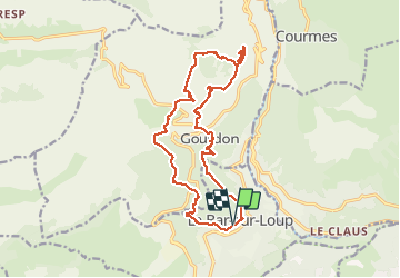
Randonnée Marche de 18,6 km à découvrir à Provence-Alpes-Côte d'Azur, Alpes-Maritimes, Le Bar-sur-Loup. Cette randonnée est proposée par domi06.
Description
Départ de Bar Sur Loup Parking Guintran. Rejoindre la B 19 puis 20 par la D303 puis chemin de Bessurane. GR51. On rejoint le chemin du Paradis , sentier ancestral , succession de marches et d'épingles jusqu'à Gourdon. Traversez la D3 puis B9 et B7 jusqu'a l'aven du col de Cavillore. Prendre un petit sentier surplombant les barres de Cavillore jusqu'à l'ancienne habitation troglodytique. Attention passage aérien avec main courante. Revenir sur ses pas et prendre une sente au 9ème km qui vous mènera à une cabane de berger dans laquelle vous découvrirez une stalactite! Reprendre le chemin plus ou moins hors sentier pour rejoindre le GR51 , que l'on quitte à environ 11km, pour rejoindre la D12 que l'on traverse. Prendre le PR qui descend jusqu'à la source de Naouq, continuer jusqu'à la D3, traverser. Aven de Garagaï, B23,22,21.
Localisation
Commentaires
Randonnées à proximité
![Randonnée Marche Gourdon - Plateau de Cavillore, la Forteresse - Gourdon - Photo](https://media.geolcdn.com/t/375/260/ext.jpg?maxdim=2&url=https%3A%2F%2Fservices.sitytrail.com%2FGeolivesWS%2FDownloadMedia.ashx%3FTrailID%3D214895%26Media%3D15446_1.jpg)
![Marche Marche](https://static1.geolcdn.com/sitytour/trail-icons/101.png)
Marche
![](/images/other/stat-length.png)
![](https://static1.geolcdn.com/siteimages/upload/files/16400158638029165_repeat_loop_refresh_sync_direction_icon.png)
![Randonnée Marche Le Bar-sur-Loup - Le Bar sur Loup Gourdon Barre et plateau de Cavillore réel - Photo](https://media.geolcdn.com/t/375/260/c167fd77-8053-444f-a9c7-0c602a316e76.jpg&format=jpg&maxdim=2)
![Marche Marche](https://static1.geolcdn.com/sitytour/trail-icons/101.png)
Marche
![](/images/other/stat-length.png)
![](https://static1.geolcdn.com/siteimages/upload/files/16400158638029165_repeat_loop_refresh_sync_direction_icon.png)
![Randonnée Marche Le Bar-sur-Loup - rando - Photo](https://media.geolcdn.com/t/375/260/fa0ef731-2bd1-40ee-a714-99f05472c6fe.jpg&format=jpg&maxdim=2)
![Marche Marche](https://static1.geolcdn.com/sitytour/trail-icons/101.png)
Marche
![](/images/other/stat-length.png)
![](https://static1.geolcdn.com/siteimages/upload/files/16400158638029165_repeat_loop_refresh_sync_direction_icon.png)
![Randonnée A pied Le Rouret - Le Camp romain - Photo](https://media.geolcdn.com/t/375/260/d6aefa76-dc44-4fc7-8d77-d19148310732.jpeg&format=jpg&maxdim=2)
![A pied A pied](https://static1.geolcdn.com/sitytour/trail-icons/100.png)
A pied
![](/images/other/stat-length.png)
![](https://static1.geolcdn.com/siteimages/upload/files/16400158638029165_repeat_loop_refresh_sync_direction_icon.png)
![Randonnée A pied Le Bar-sur-Loup - Circuit de la Malle - Photo](https://media.geolcdn.com/t/375/260/9cf230aa-9298-45ef-9b30-612a3965bbab.jpeg&format=jpg&maxdim=2)
![A pied A pied](https://static1.geolcdn.com/sitytour/trail-icons/100.png)
A pied
![](/images/other/stat-length.png)
![](https://static1.geolcdn.com/siteimages/upload/files/16400158638029165_repeat_loop_refresh_sync_direction_icon.png)
![Randonnée A pied Le Bar-sur-Loup - Circuit du Paradis - Photo](https://media.geolcdn.com/t/375/260/c599f589-6942-4b9f-bfea-287eb9516c31.jpeg&format=jpg&maxdim=2)
![A pied A pied](https://static1.geolcdn.com/sitytour/trail-icons/100.png)
A pied
![](/images/other/stat-length.png)
![](https://static1.geolcdn.com/siteimages/upload/files/16400158638029165_repeat_loop_refresh_sync_direction_icon.png)
![Randonnée A pied Gourdon - Plateau de Cavillore - Photo](https://media.geolcdn.com/t/375/260/094c0018-0a4d-4f34-8879-15bc82519f15.jpeg&format=jpg&maxdim=2)
![A pied A pied](https://static1.geolcdn.com/sitytour/trail-icons/100.png)
A pied
![](/images/other/stat-length.png)
![](https://static1.geolcdn.com/siteimages/upload/files/16400158638029165_repeat_loop_refresh_sync_direction_icon.png)
![Randonnée A pied Courmes - Plateau de Saint-Barnabé - Photo](https://media.geolcdn.com/t/375/260/e5884674-6345-4525-aa20-82da8aac2558.jpeg&format=jpg&maxdim=2)
![A pied A pied](https://static1.geolcdn.com/sitytour/trail-icons/100.png)
A pied
![](/images/other/stat-length.png)
![](https://static1.geolcdn.com/siteimages/upload/files/16400158638029165_repeat_loop_refresh_sync_direction_icon.png)
![Randonnée A pied Roquefort-les-Pins - Le Rucher - Photo](https://media.geolcdn.com/t/375/260/8984dec4-46ee-4507-9355-103df05628e2.jpeg&format=jpg&maxdim=2)
![A pied A pied](https://static1.geolcdn.com/sitytour/trail-icons/100.png)
A pied
![](/images/other/stat-length.png)
![](https://static1.geolcdn.com/siteimages/upload/files/16400158638029165_repeat_loop_refresh_sync_direction_icon.png)