Randonnée V.T.T. Yvoir - GODINNE ... Tienne des Morts. - Photo

GODINNE ... Tienne des Morts.

 GerardBouche
GerardBouche

Utilisateur

© OpenStreetMap contributors
Longueur
Longueur
27 km
Altitude max
Altitude max
249 m
Dénivelé positif
Dénivelé positif
461 m
Km-Effort
Km-Effort  
33 km
Altitude min
Altitude min
72 m
Dénivelé négatif
Dénivelé négatif
461 m
Boucle
Boucle
Oui
Date de création :
2021-04-21 12:52:55.354
Dernière modification :
2021-04-22 07:30:37.905

(0 Avis)

V.T.T.
V.T.T.
1h51
Difficulté : Moyen

Scannez ce code QR pour ouvrir la randonnée dans l'application SityTrail

Application GPS de randonnée GRATUITE

Logo SityTrail SityTrail

IGN / Instituts géographiques

Télécharger SityTrail sur l'App Store Télécharger SityTrail sur Google Play

Logo SityTrail SityTrail World

Le monde est à vous

Télécharger SityTrail sur l'App Store Télécharger SityTrail sur Google Play Télécharger SityTrail sur Huawei AppGallery

À propos

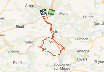
Randonnée V.T.T. de 27 km à découvrir à Wallonie, Namur, Yvoir. Cette randonnée est proposée par GerardBouche.

Description

Par le Chât.-Fme de Moulins jusqu'au village de Haut-le-Wastia. Descente par le Tienne des Morts, le Bois du Curé et la Ferme des Granges avant de retrouver les rives de Meuse et le hameau de Houx.

Profil altimétrique

Photos

Localisation

Pays :
Belgique
Région :
Wallonie
Département/Province :
Namur
Commune :
Yvoir
Localité :
Godinne
Départ:(UTM)
632609 ; 5578703 (31U) N.

Randonnées à proximité

Randonnée Marche Profondeville - RL-GG-19_Lustin_Namur - Photo
Marche
PRO

Marche

Très difficile
(13)
Profondeville, Wallonie, Namur, Belgique
22 km | 28 km-effort
6h 7min
Non
Randonnée Marche Anhée - RB-Na-22_Bioul_via-racc - Photo
Marche
PRO

Marche

Très difficile
(6)
Anhée, Wallonie, Namur, Belgique
16,7 km | 21 km-effort
4h 52min
Oui
Randonnée Marche Anhée - RB-Na-22_Bioul - Photo
Marche
PRO

Marche

Très difficile
(11)
Anhée, Wallonie, Namur, Belgique
19,5 km | 25 km-effort
5h 46min
Oui
Randonnée Marche Yvoir - RB-Na-21_Mont - Photo
Marche
PRO

Marche

Très difficile
(6)
Yvoir, Wallonie, Namur, Belgique
22 km | 30 km-effort
6h 51min
Oui
Randonnée Marche Profondeville - RB-Na-20_Profondeville_via-racc-2 - Photo
Marche
PRO

Marche

Très difficile
(11)
Profondeville, Wallonie, Namur, Belgique
14,6 km | 22 km-effort
4h 53min
Oui
Randonnée Marche Profondeville - RB-Na-20_Profondeville - Photo
Marche
PRO

Marche

Très difficile
(16)
Profondeville, Wallonie, Namur, Belgique
18,5 km | 26 km-effort
5h 55min
Oui
Randonnée Marche Yvoir - RB-Na-03_Houx - Photo
Marche
PRO

Marche

Difficile
(11)
Yvoir, Wallonie, Namur, Belgique
22 km | 30 km-effort
7h 1min
Oui
Randonnée Marche Yvoir - RL-GG-38_Godinne_Dinant - Photo
Marche
PRO

Marche

Très difficile
(6)
Yvoir, Wallonie, Namur, Belgique
19,5 km | 27 km-effort
6h 13min
Non
Randonnée Marche Anhée - RF-Na-05 Annevoie, côté Jardins_Grande-boucle - Photo
Marche
PRO

Marche

Moyen
(11)
Anhée, Wallonie, Namur, Belgique
11,3 km | 14,5 km-effort
3h 6min
Oui


Fermer
Mes abonnements