![](/images/other/stat-length.png)
![Randonnée Marche Porte-du-Ried - Sur les sentiers d'Holtzwihr et de Riedwihr - Photo](https://media.geolcdn.com/t/1900/400/6928e266-2e52-49c8-9ebd-9a70ab6a481f.jpg&format=pjpeg&maxdim=2)
Sur les sentiers d'Holtzwihr et de Riedwihr
zazie
Utilisateur
![Longueur](/images/other/stat-length.png)
![Altitude max](https://static1.geolcdn.com/siteimages/upload/files/1508320355ic_sort_altitude_max_24dp.png)
![Dénivelé positif](https://static1.geolcdn.com/siteimages/upload/files/1508320355ic_sort_den_pos_24dp.png)
![Km-Effort](/images/other/stat-length.png)
![Altitude min](https://static1.geolcdn.com/siteimages/upload/files/1508320355ic_sort_altitude_min_24dp.png)
![Dénivelé négatif](https://static1.geolcdn.com/siteimages/upload/files/1508320355ic_sort_den_neg_24dp.png)
![Boucle](https://static1.geolcdn.com/siteimages/upload/files/16400158638029165_repeat_loop_refresh_sync_direction_icon.png)
![Marche](https://static1.geolcdn.com/sitytour/trail-icons/101.png)
3h12
Difficulté : Très facile
![Scannez ce code QR pour ouvrir la randonnée dans l'application SityTrail](https://capi.geolives.com/qq0zvz2zws4bq2lad0pu/sitytour/trails/2756031/qr.png?size=200)
Application GPS de randonnée GRATUITE
À propos
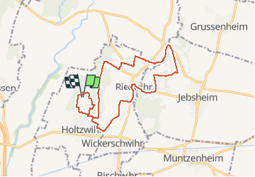
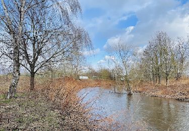
Randonnée Marche de 16,6 km à découvrir à Grand Est, Haut-Rhin, Porte-du-Ried. Cette randonnée est proposée par zazie.
Description
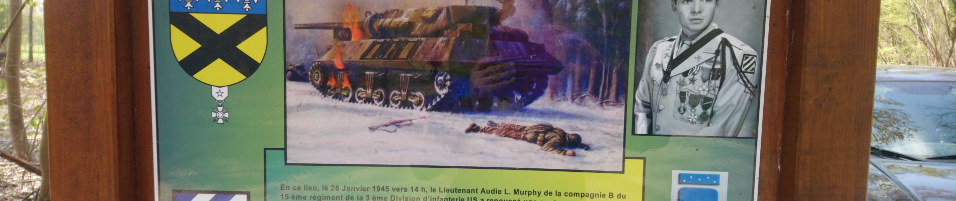
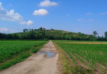
Enchaînement des nombreux sentiers botaniques, de la martre, de la paix et de l'alouette pour joindre en boucle les deux villages.
Attention, quelques passages le long des routes départementales, selon les sentiers délimités.
Peu de partie ombragée.
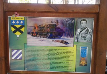
Fontaine à eau à l'abri, commune d'Holzwihr. L'abri est actuellement démonté.
Localisation
Commentaires
Randonnées à proximité
![Randonnée Course à pied Colmar - Covid-19 - A la recherche du cercle parfait - Photo](https://media.geolcdn.com/t/375/260/ext.jpg?maxdim=2&url=https%3A%2F%2Fstatic1.geolcdn.com%2Fsiteimages%2Fupload%2Ffiles%2F1524743154running.jpg)
![Course à pied Course à pied](https://static1.geolcdn.com/sitytour/trail-icons/103.png)
Course à pied
![](/images/other/stat-length.png)
![](https://static1.geolcdn.com/siteimages/upload/files/16400158638029165_repeat_loop_refresh_sync_direction_icon.png)
![Randonnée Marche Colmar - grand tour de Colmar - Photo](https://media.geolcdn.com/t/375/260/ext.jpg?maxdim=2&url=https%3A%2F%2Fstatic1.geolcdn.com%2Fsiteimages%2Fupload%2Ffiles%2F1553511878bg_sport_marche.png)
![Marche Marche](https://static1.geolcdn.com/sitytour/trail-icons/101.png)
Marche
![](/images/other/stat-length.png)
![](https://static1.geolcdn.com/siteimages/upload/files/16400158638029165_repeat_loop_refresh_sync_direction_icon.png)
![Randonnée Marche Colmar - Colmar petite Venise - Photo](https://media.geolcdn.com/t/375/260/cb1a55ed-d7ca-476a-8a88-d48c10da04cb.jpg&format=jpg&maxdim=2)
![Marche Marche](https://static1.geolcdn.com/sitytour/trail-icons/101.png)
Marche
![](/images/other/stat-length.png)
![](https://static1.geolcdn.com/siteimages/upload/files/16400158638029165_repeat_loop_refresh_sync_direction_icon.png)
![Randonnée Marche Porte-du-Ried - Sentiers botaniques d'Holtzwihr et de Riedwihr - Photo](https://media.geolcdn.com/t/375/260/76e2a4c0-424d-4b89-956a-3b59b74bc678.jpg&format=jpg&maxdim=2)
![Marche Marche](https://static1.geolcdn.com/sitytour/trail-icons/101.png)
Marche
![](/images/other/stat-length.png)
![](https://static1.geolcdn.com/siteimages/upload/files/16400158638029165_repeat_loop_refresh_sync_direction_icon.png)
![Randonnée V.T.C. Colmar - Vélo randonnée Colmar Guebwiller - Photo](https://media.geolcdn.com/t/375/260/6cf00bf4-257c-4f82-9b53-86096a3e95e9.jpg&format=jpg&maxdim=2)
![V.T.C. V.T.C.](https://static1.geolcdn.com/sitytour/trail-icons/203.png)
V.T.C.
![](/images/other/stat-length.png)
![](https://static1.geolcdn.com/siteimages/upload/files/16400158638029165_repeat_loop_refresh_sync_direction_icon.png)
![A pied A pied](https://static1.geolcdn.com/sitytour/trail-icons/100.png)
A pied
![](/images/other/stat-length.png)
![](https://static1.geolcdn.com/siteimages/upload/files/16400158638029165_repeat_loop_refresh_sync_direction_icon.png)
![Randonnée Marche Colmar - Colmar - Circuit découverte - Photo](https://media.geolcdn.com/t/375/260/ext.jpg?maxdim=2&url=https%3A%2F%2Fservices.sitytrail.com%2FGeolivesWS%2FDownloadMedia.ashx%3FTrailID%3D317123%26Media%3D16273_5.jpg)
![Marche Marche](https://static1.geolcdn.com/sitytour/trail-icons/101.png)
Marche
![](/images/other/stat-length.png)
![](https://static1.geolcdn.com/siteimages/upload/files/16400158638029165_repeat_loop_refresh_sync_direction_icon.png)
![Randonnée Marche Ostheim - Le long de la rivière Fecht à Ostheim en France - Photo](https://media.geolcdn.com/t/375/260/e49f18ff-da2a-44e2-88bc-a804e5f08011.jpeg&format=jpg&maxdim=2)
![Marche Marche](https://static1.geolcdn.com/sitytour/trail-icons/101.png)
Marche
![](/images/other/stat-length.png)
![](https://static1.geolcdn.com/siteimages/upload/files/16400158638029165_repeat_loop_refresh_sync_direction_icon.png)
![Randonnée Marche Colmar - champignons - Photo](https://media.geolcdn.com/t/375/260/d0e9264b-566e-43f0-aa52-eb3e222f3598.jpg&format=jpg&maxdim=2)
![Marche Marche](https://static1.geolcdn.com/sitytour/trail-icons/101.png)