![](/images/other/stat-length.png)
![Randonnée Marche Boulbon - Boulbon Vallon des Cavaillonès - Photo](https://media.geolcdn.com/t/1900/400/26ae9ef7-5be3-48ee-bebe-b9320bcbd58f.jpg&format=pjpeg&maxdim=2)
Boulbon Vallon des Cavaillonès
Manoune
Utilisateur
![Longueur](/images/other/stat-length.png)
![Altitude max](https://static1.geolcdn.com/siteimages/upload/files/1508320355ic_sort_altitude_max_24dp.png)
![Dénivelé positif](https://static1.geolcdn.com/siteimages/upload/files/1508320355ic_sort_den_pos_24dp.png)
![Km-Effort](/images/other/stat-length.png)
![Altitude min](https://static1.geolcdn.com/siteimages/upload/files/1508320355ic_sort_altitude_min_24dp.png)
![Dénivelé négatif](https://static1.geolcdn.com/siteimages/upload/files/1508320355ic_sort_den_neg_24dp.png)
![Boucle](https://static1.geolcdn.com/siteimages/upload/files/16400158638029165_repeat_loop_refresh_sync_direction_icon.png)
![Marche](https://static1.geolcdn.com/sitytour/trail-icons/101.png)
5h40
Difficulté : Moyen
![Scannez ce code QR pour ouvrir la randonnée dans l'application SityTrail](https://capi.geolives.com/qq0zvz2zws4bq2lad0pu/sitytour/trails/2755203/qr.png?size=200)
Application GPS de randonnée GRATUITE
À propos
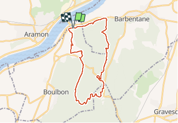
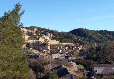
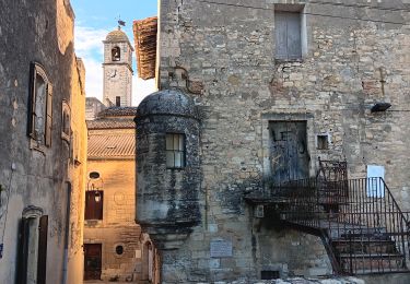
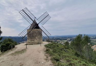
Randonnée Marche de 16,6 km à découvrir à Provence-Alpes-Côte d'Azur, Bouches-du-Rhône, Boulbon. Cette randonnée est proposée par Manoune.
Description
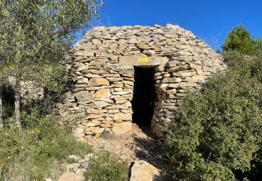
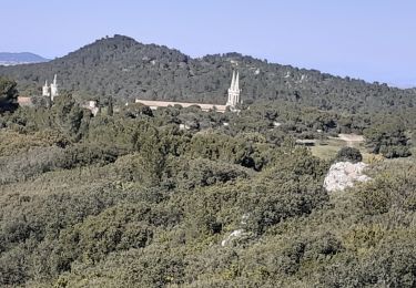
Départ de la zone du Colombier de Boulbon. Mas Livent, ligne haute tension, Cadeneau, Suivre des crêtes, parking de Frigolet, Rochers de Raous, Vallon des Cavaillonès, problème au petit mas de Grès, La Cantarelle, Carrières de Brun, Parking. Belle randonnée, à part la petite partie au niveau du Mas de Grès.
Attention ,beaucoup de chemin , suivre le GPS, sur les crêtes suivre des points rouge ou vert.
Localisation
Commentaires
Randonnées à proximité
![Randonnée Marche Boulbon - Boulbon PR40 - Photo](https://media.geolcdn.com/t/375/260/ext.jpg?maxdim=2&url=https%3A%2F%2Fservices.sitytrail.com%2FGeolivesWS%2FDownloadMedia.ashx%3FTrailID%3D233193%26Media%3D20131101145846.jpg)
![Marche Marche](https://static1.geolcdn.com/sitytour/trail-icons/101.png)
Marche
![](/images/other/stat-length.png)
![](https://static1.geolcdn.com/siteimages/upload/files/16400158638029165_repeat_loop_refresh_sync_direction_icon.png)
![Randonnée Marche Aramon - Les Castillones - Photo](https://media.geolcdn.com/t/375/260/ed06a468-8718-46c2-85f4-099025efba3e.jpg&format=jpg&maxdim=2)
![Marche Marche](https://static1.geolcdn.com/sitytour/trail-icons/101.png)
![Randonnée Marche Boulbon - Boulbon Barbentane Frigolet - Photo](https://media.geolcdn.com/t/375/260/db98e8af-4738-41d8-a5cc-4102fa5d0520.jpg&format=jpg&maxdim=2)
![Marche Marche](https://static1.geolcdn.com/sitytour/trail-icons/101.png)
Marche
![](/images/other/stat-length.png)
![](https://static1.geolcdn.com/siteimages/upload/files/16400158638029165_repeat_loop_refresh_sync_direction_icon.png)
![Randonnée A pied Boulbon - Boulbon et le Moulin Bonnet - Photo](https://media.geolcdn.com/t/375/260/ext.jpg?maxdim=2&url=https%3A%2F%2Fstatic1.geolcdn.com%2Fsiteimages%2Fupload%2Ffiles%2F1545311037marcheuse_200dpi.jpg)
![A pied A pied](https://static1.geolcdn.com/sitytour/trail-icons/100.png)
A pied
![](/images/other/stat-length.png)
![](https://static1.geolcdn.com/siteimages/upload/files/16400158638029165_repeat_loop_refresh_sync_direction_icon.png)
![Randonnée Marche Aramon - aramon - les castillonnes - Photo](https://media.geolcdn.com/t/375/260/631556ce-9f18-4093-a88d-7e024a6992af.jpg&format=jpg&maxdim=2)
![Marche Marche](https://static1.geolcdn.com/sitytour/trail-icons/101.png)
Marche
![](/images/other/stat-length.png)
![](https://static1.geolcdn.com/siteimages/upload/files/16400158638029165_repeat_loop_refresh_sync_direction_icon.png)
![Randonnée Marche Tarascon - PF-Tarascon - Saint-Michel-de-Frigolet - Moulin Bonnet - Boulbon - XA - 21.03.2022; 21 03 2022 - Photo](https://media.geolcdn.com/t/375/260/b8e241eb-ef04-456e-aea8-aa8c64b4ade3.jpg&format=jpg&maxdim=2)
![Marche Marche](https://static1.geolcdn.com/sitytour/trail-icons/101.png)
Marche
![](/images/other/stat-length.png)
![](https://static1.geolcdn.com/siteimages/upload/files/16400158638029165_repeat_loop_refresh_sync_direction_icon.png)
![Randonnée Marche Barbentane - Barbentane La Tour de Guet - Photo](https://media.geolcdn.com/t/375/260/ae2351a1-8ce3-4374-be17-9ab77a5cc2c6.jpg&format=jpg&maxdim=2)
![Marche Marche](https://static1.geolcdn.com/sitytour/trail-icons/101.png)
Marche
![](/images/other/stat-length.png)
![](https://static1.geolcdn.com/siteimages/upload/files/16400158638029165_repeat_loop_refresh_sync_direction_icon.png)
![Marche Marche](https://static1.geolcdn.com/sitytour/trail-icons/101.png)
Marche
![](/images/other/stat-length.png)
![](https://static1.geolcdn.com/siteimages/upload/files/16400158638029165_repeat_loop_refresh_sync_direction_icon.png)
![Randonnée Marche Tarascon - FRIGOLET Gratte Semelle - Photo](https://media.geolcdn.com/t/375/260/4245b54d-ccac-48c1-b4a1-cf4227c37eb7.jpg&format=jpg&maxdim=2)
![Marche Marche](https://static1.geolcdn.com/sitytour/trail-icons/101.png)
Marche
![](/images/other/stat-length.png)
![](https://static1.geolcdn.com/siteimages/upload/files/16400158638029165_repeat_loop_refresh_sync_direction_icon.png)